

Kentucky map
Bowling Green map
About 79,076 people live here (Census Bureau, 2024 estimate). The sheet's index lists 300 streets; Louisville Road, Russellville Road and Nashville Road cross the most grid squares. Things to do inside the boundary: Lost River Cave, National Corvette Museum and The Historic Railpark and Train Museum.
Open the map (PDF, US Letter)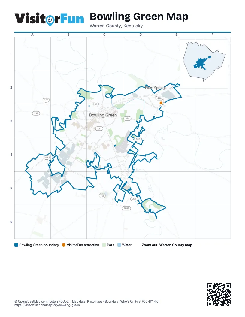
Street index of Bowling Green
Each street on the sheet and the grid squares it crosses.
- Interstate Highway 65D4, C5, D5
- Louisville RoadE1, F1, C2, D2, E2, C3
- Russellville RoadB3, C3, A4, B4, A5
- Nashville RoadC3, B4, C4, A5, B5
- Scottsville RoadC3, C4, C5, D5
- Campbell LaneB4, C4
- Lovers LaneD3, C4, D4
- 31-W By-PassC3
- Veterans Memorial LaneB2, C2, B3, C3, B4
- Glasgow RoadF1, F2
- Louisville Road/31WE1, F1, D2, E2
- Fairview AvenueC3, D3
- Kentucky StreetC3
- Porter PikeD2, D3
- Old Louisville RoadC2, D2
- Morgantown RoadB3
- Adams StreetC3
- University BoulevardC3
- East 6th AvenueC3
- Riverview DriveC2, C3
- Broadway AvenueC3
- East 7th AvenueC3
- West 6th AvenueC3
- Tobacco RoadC2
- Lowe AvenueC2
- Cemetery RoadD3
- Cave Mill RoadB4, C4
- Dishman LaneB4, C4
- Ken Bale BoulevardD4, C5, D5
- Cumberland Trace RoadD4, D5
- Plum Springs LoopD2, E2
- Three Springs RoadC5
- Gordon AvenueC2, C3
- Shive LaneC4, D4
- Mt Olivet RoadE1
- Plum Springs RoadD2
- Smallhouse RoadC3, C4, C5
- Chestnut StreetC3
- Commonwealth BoulevardF1
- Westen StreetC4
- Highland WayB4, C4
- West Main AvenueC2, C3
- State StreetC3
- Corvette DriveE2, D3, E3
- Glen Lily RoadB3, C3
- Clay StreetC3
- Fitzgerald Industrial DriveB4
- College StreetC3
- Elrod RoadB5, C5
- East 11th AvenueC3
- Old Porter PikeD2, D3
- Center StreetC3
- Old Morgantown RoadB3, C3
- College Heights BoulevardC3
- East 12th AvenueC3
- North Sunrise DriveB3
- East Main AvenueC3
- Middle Bridge Road WestD4
- Emmett AvenueB4
- Stubbins StreetC3
- Jody Richards DriveF1, F2
- Ashley CircleC4
- Bryant WayC4, D4
- Normal StC3
- Blue Level RoadA4
- Collegeview DriveB3
- West 12th AvenueC3
- Parkside DriveB3
- Old Scottsville RoadD5, E6
- Prosperity LaneF1
- Cove DriveB3
- Traffic CircleC4
- Park StreetC3
- Magnolia StreetC3
- Kelly RoadE2, F2
- Nutwood StreetC3
- Wilkinson TraceC3, D3, C4
- Grider Pond RoadB4, B5, C5
- High StreetC3
- Double Springs RoadC2
- Cumberland Ridge WayD4
- East 13th AvenueC3
- East 10th AvenueC3
- Cabell DriveC3, C4
- Church AvenueB2, C2
- Covington StreetC3, D3
- Pascoe BoulevardC4, C5
- Scottys WayE1, F1, E2, F2
- Vanderbilt DriveD5
- Kenton StreetC3
- Sherwood DriveD3
- Lois LaneB5, C5
- Century StreetA5, B5
- Mount Ayr CircleD3
- Fairway StreetC3, C4
- Creason StreetB3, C3, B4
- Hayes LaneD3
- Covington Grove BoulevardB4, C4
- Pioneer DriveB4
- Drakes Ridge LaneD5, D6
- Ironwood DriveD3
- Bristow RoadE2
- Shawnee WayB4, C4
- Cal Batsel RoadB5
- Village WayD6, E6
- Mitch McConnell WayA5, B5
- Euclid AvenueC3, D3
- Technology WayF1
- Whispering Hills BoulevardB3, B4
- Scott LaneD3
- Woodhurst StreetC4
- Shive BoulevardD4
- McFaddin Station StreetD3
- Talbott DriveD2, D3
- Shannon DriveB2, C2, B3, C3
- East 14th AvenueC3
- Bennett LaneB5
- Kobe WayA4, A5
- Bluegrass Farms BoulevardC5
- Raven AvenueC2, C3
- Greenwood LaneC5, D5
- Central AvenueA5, B5
- Memphis Junction RoadA4, B4, B5
- Lynwood WayB4
- Red Maple StreetA5
- Wakefield StreetC3, D3
- Creekwood AvenueB4
- Greenwood AlleyC3
- Hampton DriveD3
- Lehman AvenueC3
- Mount Victor LaneD3
- Hennessy WayD2, E2
- Jackson StreetC2
- Patrick WayC4
- Woodford AvenueC2, C3
- Crewdson DriveB2, B3
- Kenilwood WayC4, C5
- Traditions BoulevardD4
- Indian Hills DriveD3
- Hillview Mills BoulevardA4
- Church StreetC2, C3
- Old Barren River RoadB2, C2
- East 2nd AvenueC3
- Gator WayD5
- Cheyenne DriveC4
- Old Nashville RoadB4, B5
- Normalview DriveC3
- Fern Hill StreetB3
- No 1 Fruit of the Loom DriveD4
- Fair StreetC3
- John D Jones RoadA4
- Avenue of ChampionsC3
- Pearl StreetC2
- Ridgecrest WayC3, C4
- Walden RoadB3
- Brownslock RoadC2, C3
- Springhill AvenueB3
- Mohawk DriveC4
- East 15th AvenueC3
- Webb DriveC2, C3
- Newberry StreetC3, D3
- Mooreland DriveD3
- Gary Farms BoulevardC4
- Rodeo LaneA4
- Hunting Creek DriveC4, C5
- Eastland StreetC4
- West Park DriveC4
- North Lee DriveB2, B3
- College Suite ApartmentsC4
- High Rail WayC2, D2
- Overlook LaneD5, D6
- Boatlanding RoadC2
- Loop DriveB3
- Brentmoor AvenueB3, B4
- Mc Elroy WayC3
- East 4th AvenueC3
- Moonlite AvenueB3
- Robin AvenueB3
- East 8th AvenueC3
- Cedar Ridge RoadB3, C3
- Chandler DriveC4
- Duchess DriveB3
- Tomblinson WayB3
- Richland DriveD3
- Oliver StreetC3, C4
- Traditions AlleyD4
- Ridgeside AvenueC4
- Audubon DriveB3
- Commerce StreetD2
- Roselawn WayC3
- Karen AvenueC4
- Kendale StreetD4
- Vine StreetC3
- Bent Tree AvenueC3, D3
- Hickory StreetB3
- Cynthia Lynn AvenueD4
- Ewing Ford RoadD3
- Searcy WayC4, D4
- Bryant Way ApartmentsD4
- Graham DriveC2, C3
- Scott WayC2
- Victoria StreetC2
- Newman WayB4, C4
- Beauty AvenueC2
- Southwood CourtB5
- White Dogwood DriveA5
- East 5th AvenueC3
- Huntington StreetC3, D3
- Power StreetC2
- Rodes DriveC3
- Ashmoor AvenueB3, B4
- East McLellan RoadA5
- Progress AvenueA5
- North Graham StreetD2
- Stonehenge AvenueB3
- Crossridge BoulevardC4
- Valleybrook AvenueB3
- Turkey Run DriveA5
- Pedigo WayC4, D4
- Eastwood AvenueC3
- Belleview AvenueB4
- Clearview AvenueB3
- Storey AvenueB4
- Parker AvenueD2
- Red Clover AvenueA5
- Dorchester DriveD3
- Rock Creek DriveB3
- Whitney DriveA4, A5
- Collett LaneD3
- Beech StreetC2
- Old Nashville Rd Loop No 2B5
- Jennings CourtB3
- Patton WayB4
- McCubbin DriveC3, C4
- Rockingham AvenueC4
- Crossings BoulevardC4, C5
- East 3rd AvenueC3
- Lyda AvenueC4
- Stonebridge LaneB4
- Holly DriveB3
- Cedar Hollow DriveA5
- Old Stone WayD6
- South Park DriveC3
- Atlanta WayD5
- Harrison RoadE2
- Brenner StreetE1, E2
- Utah DriveC4
- Spring AlleyC3
- South Sunrise DriveB3
- Combs DriveC2
- Natcher LaneC3
- Peach Blossom LaneD5
- Virginia DriveB3
- Karen CircleC4
- Mimosa AlleyC3
- Windover AvenueA4
- Grandview StreetB3, B4
- Maple LaneA4, B4
- Mel Browning StreetD5
- Peachtree LaneD5
- Clifford WayD3
- Hays-Martin RoadF2
- Kensington WayD3
- Bakersfields WayB4
- Cardinal WayD3
- Catherine DriveB3
- Garvin LaneC2
- Natchez Trace AvenueD4
- Ridgewood DriveD3
- Rosie CourtD4
- Greyrock DriveA5
- Interstate DriveE2
- Yuma DriveB4
- Bramblebush DriveD3
- Loop StreetB3
- Claremoor AvenueB3, B4
- West 11th AvenueC3
- West 10th AvenueC3
- Greenlawn AvenueC3
- Lost CircleB4
- Riverwood AvenueC3
- Thoroughbred DriveC4
- Willow WayD3
- Cottonwood DriveD3
- Payne StreetC3
- Edgefield WayB4, C4
- Cave Springs AvenueC5
- Threewood CircleC3
- Collett AvenueC3
- Kami DriveC5
- Media DriveB3
- Barnard WayD3
- Sandra StreetB3
- Brookshore AvenueB3
- Parkhurst DriveB3
- Lake Shore DriveB5, C5
- Melrose StreetC4
- Pirates Cove LaneD2
- Ragland WayC2
- Flex Park LaneB5
Things to do on the Bowling Green map
Places on the map
- Bowling Green Ballpark
- Bowling Green High School
- Chapel Hill Cemetery
- Chuck Crume Nature Park
- CrossWinds Municipal Golf Course
- Drakes Creek Middle School
- Fairview Cemetery
- Greenwood High School
- Greenwood Mall
- H. P. Thomas Bark Park
- Hobson Grove Park
- Indian Hills Country Club
- James Hines Park
- Lampkin Park
- Limestone Lake
- Lost River Cave& Valley
- Lovers Lane Soccer Complex
- Lowe's
- Meijer
- Menards
- Mount Moriah Cemetery
- Olde Stone Golf Course
- Paul Walker Municipal Golf Course
- Pedigo Park
- Potter-Gray Elementary School
- Reservoir Hill
- Reservoir Hill Park
- Rivendell Behavioral Health
- Riverview Municipal Golf Course
- RiverWalk
- Spero Kereiakes Park
- Warren High School
- Weldon Peete Park
- Western Kentucky University
- WKU turfgrass management field
Next to Bowling Green
- Plum Springs
© OpenStreetMap contributors, Open Database License, openstreetmap.org/copyright · Map data: Protomaps · Boundary: Who's On First (CC-BY 4.0); Quattroshapes (CC BY 2.0)