

Kentucky road map
Country Music Highway map
The Country Music Highway has been a National Scenic Byway since 2002, named for its cultural qualities: about 152 miles in Kentucky. It meets 46 highways, among them I-64, US 10 and US 23. Towns along it: Ashland, Pikeville and Flatwoods.
Open the map (PDF, US Letter)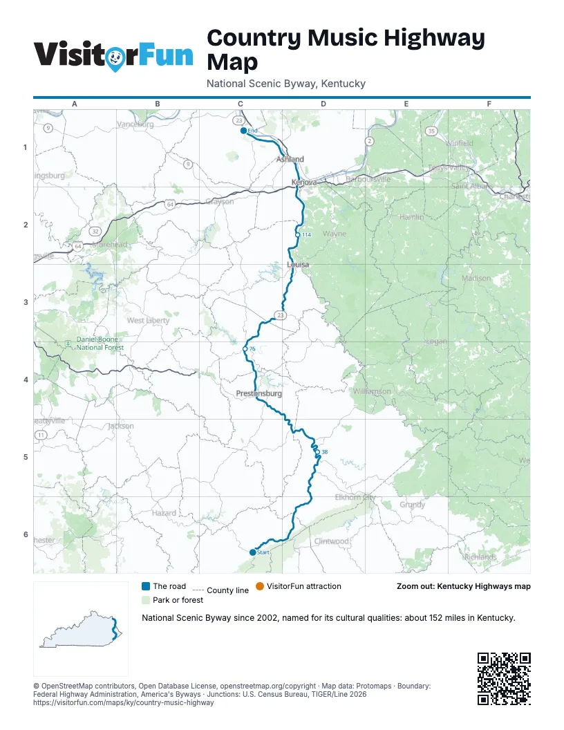
Highways it meets
Each highway it meets and the grid squares where they meet.
- KY 15C6
- KY 2034C6
- US 119C6
- KY 1862C6
- KY 3410C6
- KY 805C6
- KY 3406C6
- KY 3400C6
- US 23D6
- KY 3086D6
- KY 3174D5
- US 460D5
- KY 80D5
- US 33D5
- KY 1428C4
- KY 4C4
- KY 302C4
- US 10C4
- KY 114C4
- KY 1750C4
- KY 825C4
- KY 2039C4
- KY 40C4
- KY 321C4
- KY 1559C3
- KY 2565C3
- KY 645C3
- KY 32D3
- KY 3D2
- KY 752D2
- KY 757D2
- I-64D2
- KY 538D2
- KY 168D1
- US 60D1
- KY 5D1
- KY 693C1
- KY 1725C1
- KY 244C1
- KY 750C1
- KY 2543C1
- KY 207C1
- KY 3105C1
- KY 2541C1
- KY 1C1
- KY 2C1
Towns along the Country Music Highway
In mile order, with the grid square of each.
- Whitesburgmile 0, C6
- Maykingmile 2, C6
- Millstonemile 5, C6
- Payne Gapmile 9, C6
- Jenkinsmile 11, D6
- Virgiemile 27, D5
- Pikevillemile 34, D5
- Coal Run Villagemile 41, D5
- Betsy Laynemile 48, D5
- Dwalemile 57, C4
- Prestonsburgmile 57, C4
- Auxiermile 68, C4
- Van Learmile 71, C4
- West Van Learmile 71, C4
- Paintsvillemile 72, C4
- Louisamile 103, D3
- Catlettsburgmile 129, D1
- Ashlandmile 133, D1
- Westwoodmile 138, D1
- Russellmile 139, D1
- Bellefontemile 139, D1
- Flatwoodsmile 142, C1
- Racelandmile 143, C1
- Worthingtonmile 144, C1
- Wurtlandmile 147, C1
- Greenupmile 148, C1
Things to do on the Country Music Highway map
© OpenStreetMap contributors, Open Database License, openstreetmap.org/copyright · Map data: Protomaps · Boundary: Federal Highway Administration, America's Byways · Junctions: U.S. Census Bureau, TIGER/Line 2026