

Kentucky road map
I-69 in Kentucky map
I-69 is about 126 miles in Kentucky. It has 34 exits, from Exit 21 at mile 1 to Exit 151 at mile 126. It meets 48 highways; US 41, US 62 and KY 80 meet it in the most grid squares.
Open the map (PDF, US Letter)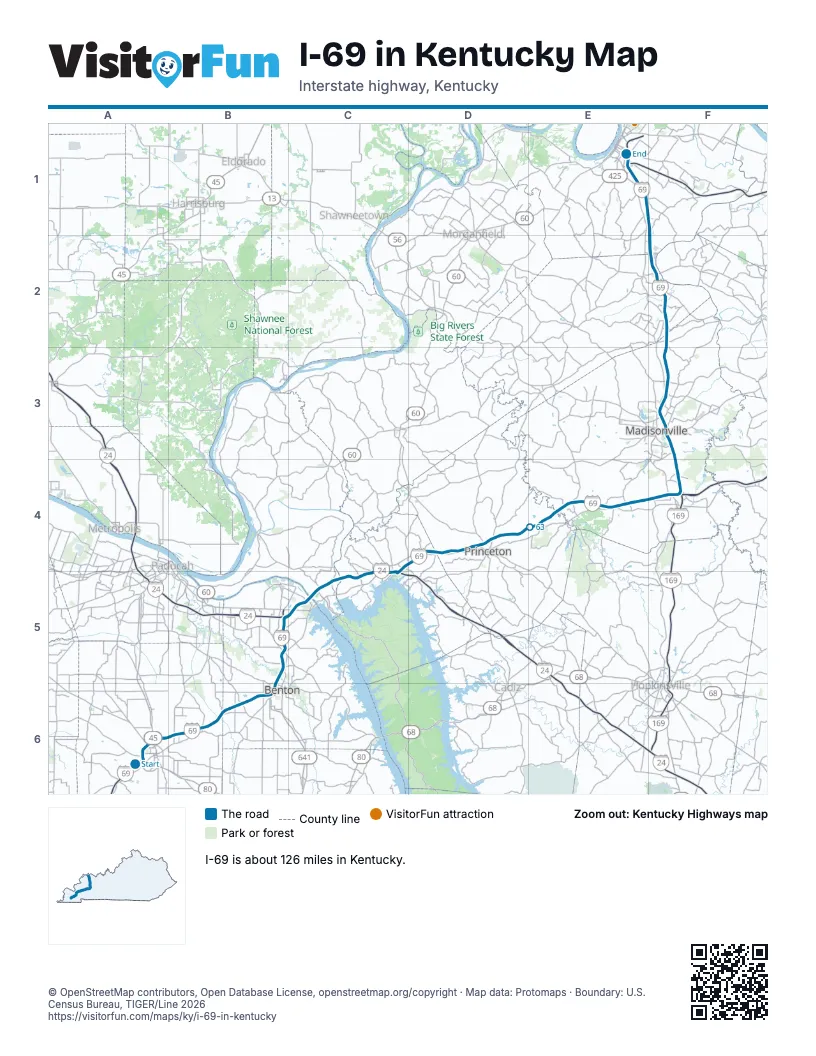
Exits on I-69 in Kentucky
Each exit in mile order, with its grid square.
- Exit 21mile 1, A6
- Exit 22mile 1, A6
- Exit 24mile 2, A6
- Exit 25mile 3, A6
- Exit 27mile 6, B6
- Exit 41mile 19, B6
- Exit 43mile 21, B6
- Exit 47mile 25, B5
- Exit 51A-Bmile 29, B5
- Exit 25Bmile 30, C5
- Exit 25Amile 30, C5
- Exit 31mile 35, C5
- Exit 40mile 44, C5
- Exit 42mile 45, C5
- Exit 68A/68Bmile 46, C4
- Exit 71mile 49, D4
- Exit 79mile 57, D4
- Exit 81mile 59, D4
- Exit 92mile 69, E4
- Exit 106A-Bmile 83, F4
- Exit 106B-Amile 83, F4
- Exit 108mile 85, F4
- Exit 111mile 89, F3
- Exit 114mile 91, F3
- Exit 116mile 92, F3
- Exit 117mile 93, F3
- Exit 120mile 97, F3
- Exit 125mile 102, F2
- Exit 134mile 110, F2
- Exit 140mile 117, F1
- Exit 148mile 125, E1
- Exit 1B/1Amile 125, E1
- Exit 149mile 126, E1
- Exit 151mile 126, E1
Highways I-69 meets
Each highway it meets and the grid squares where they meet.
- KY 80A6
- KY 121A6
- US 45A6
- KY 131B6
- KY 301B6
- KY 1949B6
- KY 348B6
- KY 408B6
- KY 795B5
- I-24C5
- US 62C5, D4
- KY 282C5
- KY 453C5
- KY 917C5
- KY 93C5
- US 641C5
- KY 91D4
- KY 139D4
- KY 293D4
- KY 2615D4
- KY 2652E4
- KY 2086E4
- KY 109E4
- KY 112E4
- KY 454E4
- KY 3059F4
- US 41E1, F3, F4
- KY 2650F4
- KY 1215F4
- KY 1622F4
- KY 813F4
- KY 1633F4
- KY 70F3
- KY 85F3
- KY 254F3
- KY 2657F3
- KY 862F3
- KY 260F3
- KY 2664F3
- KY 2663F3
- KY 2655F3
- KY 138F2
- KY 147F2
- KY 370F2
- KY 56F2
- KY 416F1
- KY 136E1
- KY 812E1
Towns along I-69 in Kentucky
In mile order, with the grid square of each.
- Mayfieldmile 0, A6
- Bentonmile 19, B6
- Calvert Citymile 30, C5
- Gilbertsvillemile 32, C5
- Kuttawamile 42, C5
- Eddyvillemile 44, C5
- Princetonmile 56, D4
- Dawson Springsmile 68, E4
- St. Charlesmile 77, E4
- Mortons Gapmile 84, F4
- Madisonvillemile 89, F3
- Hansonmile 96, F3
- Sebreemile 110, F2
- Robardsmile 114, F2
- Anthostonmile 121, E1
- Hendersonmile 125, E1
© OpenStreetMap contributors, Open Database License, openstreetmap.org/copyright · Map data: Protomaps · Boundary: U.S. Census Bureau, TIGER/Line 2026