

Kentucky map
Kenton County map
About 174,862 people live here (Census Bureau, 2024 estimate). The sheet's index lists 300 streets; Madison Pike, Dixie Highway and Decoursey Pike cross the most grid squares. Also on it: Aosta Valley, BP Pipeline Bromley Terminal and Bromley.
Open the map (PDF, US Letter)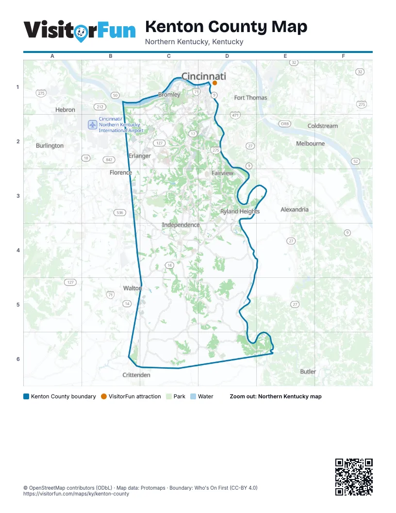
Street index of Kenton County
Each street on the sheet and the grid squares it crosses.
- Madison PikeC2, D2, C3, C4, C5, C6, D6
- Dixie HighwayC1, B2, C2, B5, C5, C6
- Walton Nicholson PikeC4
- Madison AvenueD1, D2
- Main StreetC1, D1, B2, C2, C3
- Garrard StreetD1
- Scott BoulevardD1
- West Pike StreetC1, D1
- West Martin Luther King Junior BoulevardD1
- Donaldson HighwayB2
- West 4th StreetC1, D1
- West 5th StreetC1, D1
- Houston RoadB2
- Commonwealth AvenueB2
- East Martin Luther King Junior BoulevardD1
- Clay Wade Bailey BridgeD1
- East 11th StreetD1
- West 7th StreetC1, D1
- Prospect AvenueD1
- East 4th StreetD1
- East 5th StreetD1
- West 12th StreetC1, D1
- Bullock StreetC1, D1
- Simon Kenton WayD1
- South Main StreetB5
- Decoursey PikeD2, D3, D4, D5, D6, E6
- Taylor Mill RoadD2, D3, C4, D4
- Amsterdam RoadB1, C1, B2, C2
- Turkeyfoot RoadC2, C3
- Rich RoadC5, D5, D6
- Richardson RoadB3, C3
- Highland PikeC1, D1, C2, D2
- Fowler Creek RoadC3, D3, D4
- River RoadB1, C1
- Pride ParkwayD2, D3
- Bristow RoadC3, C4
- Bracht-Piner RoadC5, C6
- Independence RoadC4
- Visalia RoadD4
- Dolwick DriveB2, C2
- Staffordsburg RoadD4
- Fiskburg RoadD6
- Buttermilk PikeC2
- Hands PikeC3, D3
- Greenup StreetD1, D2
- Mount Zion RoadB3, C3
- Kyles LaneC1, C2
- Wayman Branch RoadC3, D3
- Orphanage RoadC2
- Decoursey AvenueD2
- Anderson RoadC2, C6, D6
- Sleepy Hollow RoadC1
- Harris PikeC4, D4
- Crescent AvenueC1, C2
- Elm StreetC1, B2
- Stevenson RoadB2, C2
- Hulbert AvenueB2, C2
- Highway AvenueC1
- Stephens RoadC4, D4
- Industrial RoadB3, C3
- Pelly RoadC3
- Shaw RoadC4
- Winston AvenueD2
- Howard Litzler DriveC2, D2
- Kenton Lands RoadC2
- James AvenueB2, D2
- Collins RoadC1, C2
- Turfway RoadB2
- Crescent Springs RoadC2
- Crescent Springs PikeC2
- East 20th StreetD1
- Deverill StreetC1
- Pike StreetC1
- John A. Roebling Suspension BridgeD1
- Johnson StreetD1
- Roebling WayD1
- East 30th StreetD2
- Al Schneider BridgeD4
- East Pike StreetD1
- Maverick RoadD4
- Locust PikeD2, D3, E3
- Green RoadC4, C5
- Marshall RoadD3, D4
- Hempfling RoadC5, D5
- Moffett RoadC5, D5
- Dudley PikeC2
- Banklick RoadC4
- Kenton Station RoadD4, D5
- Bagby RoadC6
- Parkers Grove RoadC6
- Bromley Crescent Springs RoadC1, C2
- Paxton RoadC6, D6
- Old Madison PikeC2, C3
- Highwater RoadC1
- Oliver RoadC3, D3, C4
- Eastern AvenueD1, B2, D2, B3
- Eads RoadB6, C6
- Klette RoadD3
- Thomas More ParkwayC2
- Montague RoadC1
- Russell StreetD1
- Old Taylor Mill RoadD2, D3
- Mills RoadD3
- Senour RoadC3, D3
- Horsebranch RoadC2
- Whites RoadD3
- Petty RoadD4
- Magellan WayC2, D2
- Grand AvenueD2
- Devou DriveC1
- Park RoadC1, C2
- Western AvenueC1
- Courtney RoadB6
- West 6th StreetD1
- McCullum RoadC4
- Oak Island RoadD5
- West 19th StreetD1
- Cox RoadD3, D4
- Philadelphia StreetD1
- Adela AvenueC1
- Pruett RoadD3, D4
- Park LaneC1
- Parkway AvenueC1
- West 9th StreetC1, D1
- Latonia AvenueD2
- Prisoners Lake DriveC1
- Western Reserve RoadC2
- Magellan DriveC2, D2
- Wallace AvenueD1
- East 15th StreetD1
- West 3rd StreetC1, D1
- West 43rd StreetD2
- Scott StreetD1, C2
- East 2nd StreetD1
- Sidney DriveC4
- East 6th StreetD1
- West Rivercenter BoulevardD1
- Bandshell BoulevardC1
- George Huser DriveC1
- East RiverCenter BoulevardD1
- Alexander RoadD6, E6
- Independence Station RoadC3
- Percival RoadC4, B5, C5
- Steep Creek RoadD4
- Cruise Creek RoadD5, D6
- Garvey AvenueB2, C2, B3, C3
- Cody RoadC3
- Stephenson RoadC5, C6
- Riggs RoadB2, C2, C4, D4
- Wilson RoadD2, C4
- Maher RoadB4, C4
- Rector RoadD5
- Carlisle RoadC6
- Lambs Ferry RoadD3
- Porter RoadD3
- Webster RoadC3
- Narrows RoadC3
- Bowman RoadC4, D4
- Dixon RoadC5, D5
- Church StreetC1, D2
- Mann RoadD4
- Jones RoadB5, C5
- Mason RoadD2
- Sugar Camp RoadC3, D3
- Bullock Pen RoadC3
- Rosewood DriveC1, C2
- Erlanger RoadB2, C2
- Railroad DriveD3
- Hogrefe RoadC3, B4, C4
- Beechwood RoadC2
- Gardnersville RoadD6
- Klein RoadD4
- Conley RoadD4, D5
- Town Center BoulevardC2
- Vises TrailD4
- Meadow Glen DriveC3
- Phanstiehl RoadD6
- Wright RoadB4, C4
- Martin RoadD4, D5
- Mount Vernon DriveC2
- Rogers RoadC1, B2, C2
- Lipscomb RoadD3
- Edenderry DriveC1, C2
- Oak StreetC1, C2
- Bird RoadC5
- Farrell DriveC2
- Tuscanyview DriveC2, C3
- Forest AvenueC1, B2
- Hallam AvenueC2
- Park AvenueB2, D2, B3
- Graven RoadB4, C4
- Elliott RoadD6
- Shinkle RoadC2
- Villa DriveC1
- Brightleaf BoulevardC3
- Sherbourne DriveC3
- Holman AvenueD1
- Hartland BoulevardC4
- Lookout Farm DriveC2
- Grandview DriveC2
- Stablewatch DriveD3
- Spillman RoadC5
- Freedom TrailC4
- Brookwood DriveC2, C3
- Prospect Point DriveB1
- Crosby ParkwayC2, D2
- Clubhouse DriveC3, D3
- Huntington AvenueD2
- Summitrun DriveD3
- Walnut AlleyC1
- Holdsbranch RoadC2, D2, C3, D3
- Calvary RoadC3, C4
- Banklick StreetD1
- Bramlage RoadC4
- East Henry Clay AvenueC2
- Edgewood RoadC2
- Valley Trails DriveB1, B2, C2
- Open Meadow DriveC3
- Pleasant Ridge AvenueC2
- Feiser RoadD3
- Robertson RoadD2, D3
- Goshorn RoadD5, D6
- Lytle AvenueB2, B3
- Riverwatch DriveC1
- St Marys RoadD6
- Thompson AvenueC2
- Camin LaneC5
- Berlander DriveB4, C4
- East 43rd StreetD2
- Wolf RoadD3
- Lakemont DriveC3
- Trace Run RoadD5
- Center StreetD1, B2, C2, D2
- General DriveC1
- Glenhurst DriveB4
- Crystal Lake DriveC3, D4
- Pacific AvenueB2
- Stevie’s TrailD3
- Progress DriveD3
- Lunsford RoadC5, C6
- Reidlin RoadD2
- Hillside DriveD3, D4
- Charter Oak RoadC2, C3
- Meadowlark DriveC2, C3
- Ryland Lakes DriveD4
- Bethel Grove RoadD4
- Far Hills DriveC1, C3
- Locust StreetC1, D1, B2, C2
- Glenn AvenueD2
- Sierra DriveB2, C2
- Roselawn DriveD2, C4
- North Lakeshore DriveD5
- Rolling Hills DriveC2
- Foundation DriveB3, C3
- Mary StreetC1, C2
- Beechgrove DriveB3, C3
- Griststone CircleD4
- Oakland AvenueD1
- Ernstbridge RoadD4
- Williamswoods DriveC4
- Maryland AvenueD1
- Highland AvenueC2
- Magnolia CourtC2, C3
- Cleveland AvenueC1, D2
- Medical Village DriveC2
- Wesley DriveB2, C2
- Meadow Wood DriveC2
- West 33rd StreetD2
- Madonna DriveC2
- Richard Knock HighwayB5, C5
- Beech DriveC2, D2
- Village DriveC2, C3
- Autumn RoadB3, C3
- McAlpin AvenueB2
- Howe DriveD2
- Euclid AvenueD1, C2
- Hunters Green DriveC3
- Centre View BoulevardC2
- Limerick CircleD3
- Ridgewood DriveC3
- Fort Henry DriveC1
- Misty Creek DriveC2, C3
- Sugartree DriveD3, D4
- Cannonball WayC4
- Graves AvenueB2
- Gribble DriveC3
- Ishmael RoadD5
- Gripshover RoadC6
- Chardonnay ValleyC5
- New Buffington RoadB3
- Jacqueline DriveC2, C3
- Sycamore Creek DriveC3, D3
- Prestwicke DriveC2
- Stewart DriveD3
- Old State RoadC1
- Timberlake AvenueC2
- Highridge DriveD3
- Callant RoadC4
- Watkins StreetC1, D1, C2
- Burdsall AvenueC2
Places on the map
- Aosta Valley
- BP Pipeline Bromley Terminal
- Bromley
- CirclePort
- Clover Ridge
- Covington
- Crescent Springs
- Crestview Hills
- Decoursey Yard
- Devou Park
- Devou Park Golf Course
- Edgewood
- Elsmere
- Erlanger
- Fairview
- Fort Mitchell
- Fort Wright
- Fox Run Park
- Independence
- Kenton County
- Lakeside Park
- Lally Pipe & Tube
- Licking River
- Ludlow
- Mainstrasse Village
- Manor Hill
- Middleton-Mills Park
- Morning View Heritage Area
- Park Hills
- Pioneer Park
- Prospect Point & the Lofts
- River's Breeze Community
- Ryland Heights
- Saint Walburg Monastery
- Stevie's Trail
- Summit Hills Country Club
- Taylor Creek Subdivision
- Taylor Mill
- Thornhill Drag Strip
- Villa Hills
Next to Kenton County
- Alexandria
- Bellevue
- Burlington
- Butler
- Cincinnati
- Coldstream
- Crittenden
- Florence
- Fort Thomas
- Hebron
- Melbourne
- Silver Grove
- Walton
© OpenStreetMap contributors (ODbL) · Map data: Protomaps · Boundary: Who's On First (CC-BY 4.0)