

Louisiana map
Ascension Parish map
About 133,534 people live here (Census Bureau, 2024 estimate). The sheet's index lists 300 streets; River Road, Airline Highway and Main Street cross the most grid squares. Things to do inside the boundary: Houmas House Estate and Gardens.
Open the map (PDF, US Letter)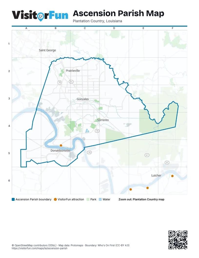
Maps inside Ascension Parish
1 map inside, from the street map of Ascension Parish down.
Street index of Ascension Parish
Each street on the sheet and the grid squares it crosses.
- Airline HighwayB2, C2, C3, C4, D4
- State Route 30A3, B3, C3
- Old Jefferson HighwayB2, B3, B4
- North Burnside AvenueC2, C3
- Highway 1 NorthA4, A5, B5
- South Burnside AvenueC3, C4
- Highway 1 SouthB5
- North Airline HighwayC3
- Main StreetC2, C4, D4, B5
- State Route 621C3
- Crawford Leblanc BoulevardC4
- Cante RoadC3
- West 10th StreetB5
- Division StreetB5
- Marchand DriveB5
- Commerce Centre DriveB2
- Albert StreetB5
- Cabela's ParkwayC3
- Highway 42C2
- East Highway 30A3
- Oak Grove-Port Vincent HighwayD2
- Bayou RoadB5
- River RoadA3, B3, B4, C4, B5, C5
- Germany RoadC2
- Roddy RoadC2, C3
- Joe Sevario RoadC2
- Weber City RoadC3, D3
- Perkins RoadB2
- State Route 44C4
- Mississippi StreetB5
- South Purpera AvenueC3
- East Bayou RoadB5
- Lafourche StreetB5
- Veterans BoulevardC3, B5
- East Ascension StreetC3
- Bluff RoadB2, B3
- Louisiana Highway 74B3
- Brittany Tower RoadC3, C4
- Cornerview RoadB3, C3
- Stringer Bridge RoadC3, D3
- Belle Helene RoadC2, B3, B4
- Black Bayou RoadC3
- Church Point RoadC3
- Bayou Narcisse RoadC3
- Beco RoadD3
- State Route 74B3, C3
- Babin RoadB3, C3
- Norwood RoadC2
- George Rouyea RoadC2, C3
- Braud RoadC2, C3
- West Orice Roth RoadC3
- Saint Patrick StreetB5
- Highway 930C2
- Parker RoadC2
- River Run Estate DriveD3
- Hornsby RoadC2
- Duplessis RoadB2, C2
- South Darla AvenueC3, C4
- State Route 929B2, C2
- West Worthy StreetC3
- Tiggy Duplessis RoadB2, B3
- Causey RoadB2, C2
- Boudreaux RoadC3
- Henry RoadB2, C2
- William Ficklin RoadC2
- L Landry RoadB3
- Merritt Evans RoadC2
- South Irma AvenueC3
- East Worthy StreetC3
- Daigle RoadC2
- Black Bayou ExtC3
- West Worthy RoadC3
- East Cornerview StreetC3
- Devall RoadC2
- Denham RoadC3
- Vatican DriveB5
- Tommy Moore RoadC2
- West Cornerview StreetC3
- Rondinaud LaneB5
- West LaneC2
- North Marchand AvenueC3
- East New River StreetC3
- South Lanoux AvenueC3
- East Bayou Narcisse StreetC3
- North Alexander AvenueC3
- North Toby StreetC3
- West Toby StreetC3
- West Ascension StreetC3
- Black Bayou ExtensionC3
- Panther RoundaboutC2
- Stinger Bridge RoadD3
- East Worthy RoadC3
- Cannon RoadC3
- Bayou Terrace RoadD2, D3, E3
- Willie Thomas RoadB4
- Gold Place RoadC3, D3
- Boyce Tower RoadD4, D5
- State Route 3140 ExtensionD4
- Old Highway 22C4, C5
- Noel RoadA4, B4
- George Lambert RoadD3
- Mulberry GroveA4, B4
- Laurel Ridge RoadD3
- Amite River RoadD2, D3
- Frank Noel RoadA5, B5
- South Saint Landry AvenueC3, C4
- West Main StreetC3
- Manchac Acres RoadB2, C2
- New River Canal RoadB3
- Fontenot RoadC3, D3
- Derrick RoadA4, B4
- Coon Trap RoadC3
- Brittany RoadC4
- Moody Dixon RoadC2
- Lake Harbor LaneC2
- River Highlands DriveE3
- Henderson Bayou RoadC2
- Little Prairie RoadC2
- Ourso RoadA5
- Louis White RoadB3
- Harry Savoy RoadD2, C3, D3
- Lemanville Cut Off RoadC5
- Ridge RoadB2, B3
- Diversion Canal RoadD3
- Brou RoadA4
- Mulberry Grove RoadA4, B4
- Ernest Floyd Road NorthC4
- Home Port DriveE3
- John Broussard RoadB2
- Timberstone DriveC2
- Rayville RoadB4
- Muddy Creek RoadC2
- Bowden RoadB4
- Lake Martin RoadD2
- 6th AvenueC5
- Pelican Point ParkwayC4
- Swamp RoadB2
- Kling RoadB3
- J D Broussard RoadC2, C3
- Camp DriveB1, B2, C2
- Darrow Pipeline RoadB4, B5
- Brown RoadB2, C4
- Summerfield Road SouthD2
- Courtyard DriveC4
- Seven Oaks AvenueB2
- Schexnayder RoadB5
- Souvigner RoadB5
- White RoadB2
- R Daigle RoadC3
- Jamie StreetC2
- Pelican Crossing DriveC4
- Jules DriveA5, B5
- Saint Vincent StreetB5
- Charleston RoadB2, C2
- Clouatre RoadC3
- Texaco RoadD4
- Belle Savanne AvenueB3
- Pertuis RoadD4
- Buddy Gore RoadC3
- K C RoadC3
- Loosemoore RoadC4
- Oneal RoadC3
- Bertville RoadC2
- Abby James RoadC2
- North Robert Wilson RoadB3, C3
- Hung-Ton-That RoadD4, E4
- Iberville StreetB5
- Lemann Derrick RoadA5
- Brittany StreetC4, D4
- Galaxy BoulevardC4
- Alligator Bayou RoadB2
- Chester Diez RoadB3
- Broussard RoadB2, B5
- Summerfield RoadD2
- Natalbany RoadB3
- Panama RoadC4
- South Hodgeson RoadC3, C4
- Melancon RoadD4
- Van Broussard RoadB2, C2
- South Riverview BoulevardC3
- Plantation BoulevardB2
- Lakehaven DriveC4
- Butch Gore RoadD2
- Evangeline DriveB5
- Quest RoadC3, B4
- Hodgeson RoadC2, D2
- Oak StreetC4, B5
- Stevenson RoadB3
- Prince RoadC3, D3
- Jay RoadC2
- Ole Homestead LaneC2
- Vindez RoadC4
- Miller RoadB2
- Brady StreetD5
- Keystone BoulevardC2
- Cal RoadB3, C3
- Oakland DriveB2
- Millien RoadA5
- Wayne Stevens RoadC3
- Plantation Court DriveB2
- Split Log RoadD3, D4
- Cy Bean RoadB5
- North Bryan AvenueC3
- Conway Village BoulevardC4
- Manchac Place DriveB2
- Denver Hurst RoadC4
- Latino StreetB5
- Magnolia Estates RoadB2
- Blythe RoadC2
- Jim Mayers RoadD2
- Lake Settlement DriveD2
- Palmetto LaneC2
- Woodland AvenueC2
- East Rome StreetC3
- C Braud RoadB3
- Penn BoulevardC2
- Raymond Tullier RoadC4, D4
- David DriveB2, C2
- Autumn View DriveC2
- West Edenborne ParkwayC4
- 2nd StreetB5
- Thibaut DriveB5
- Conway StreetD4
- Black River RoadC4
- Oak Grove ParkwayB1, B2
- Southwood Village AvenueB2
- Lessard StreetB5
- Loop 945B5
- Oak Meadow StreetB2, B3
- West New River Ext.C3
- Cotton Field AvenueC2
- Forest Oak StreetC2
- Sage Field CourtC2
- Terraceside DriveC2
- Loop RoadC2, D2
- Oak HarborC2
- South Park AvenueB2, C3
- Newman Nickens RoadC2
- Braud StreetD4
- Poirrier RoadD3, D4
- State Route 936D3, D4
- Donaldson DriveC4
- Galvez AvenueC2
- Old Dutchtown AvenueB3
- Acosta RoadB5
- Church StreetB5
- Maginnis StreetB5
- South Edward AvenueC3
- Stewart RoadC2, B5
- Savoy RoadD3
- Bill Morgan RoadC2
- La Rochelle RoadC2
- Parent RoadC3
- Rena Melancon RoadB5
- McCall RoadB5
- Rennes DriveC2
- Cypress Hollow AvenueB3
- Oakland Crossing BoulevardB2
- Deck BoulevardB3
- Railroad AvenueB5
- Fountainbleau DriveC2
- Conifer DriveC2
- Saint Elmo StreetB5, C5
- Beverly Hills DriveB2
- Pine StreetB5
- Hemingway DriveC4
- Summerfield Road NorthD2
- Greenfield CrossingC2
- Riverton ParkwayC4
- Beau Douglas AvenueC4
- State Rt 75B5
- West New River RoadC3
- Caribbean DriveB2
- Bluff Lakes DriveB2, B3
- Wynstone DriveC2
- Buxton RoadD3
- Prairie DriveB2
- Royal Oak DriveB3
- Ryan AvenueB2
- Houmas StreetB5
- Dutchtown Lakes DriveB3
- New River RoadD4
- Country DriveC2
- Old Reserve DriveB2, C2
- Airport Industrial RoadC4
- Orleans DriveC3
- Oakridge DriveC2
- Cotton DriveB5
- Ronda AvenueC2
- Opelousas StreetB5
- Lamar Moran RoadD3
- Legacy Hills DriveB3
- Old Maplewood DriveB2
- Walls Cemetery RoadD2
- Fabacher DriveB2, C2
- Legacy Oaks DriveC3
- Mindy Way AvenueB3
- Evan Hall RoadA5
- Oak Alley DriveB3
- Longwood AvenueB2
Things to do on the Ascension Parish map
Places on the map
- Airline Plaza
- Amite River Wildlife Sanctuary
- Ascension Catholic Cemetery
- Ascension Hospital
- Ascension Parish Library
- Ascension Parish Police Jury
- Big John's Landing
- Bluff Middle School
- Brittany Post Office
- Burnside Post Office
- Butch Gore Memorial Park
- Cajun Industries Soccer Complex
- Cajun Village
- Cal Mire Field
- Central Middle School
- Central Primary School
- City of Donaldsonville
- Colonial Landfill
- Darrow Post Office
- Donaldsonville
- Donaldsonville High School
- Donaldsonville Post Office
- Donaldsonville Primary School
- Double H Ranch Airport
- Duplessis Post Office
- Duplessis Primary School
- Dutchtown High School
- East Ascension High School
- G W Carver Primary School
- Galvez Primary School
- Geismar Post Office
- Gonzales
- Lamar Dixon Expo Center
- Louisiana Regional Airport
- Nutrien Landfill
- Pelican Point Golf and Country Club
- Prairieville High School
- Saint Elizabeth Hospital
- Sorrento
- Tanger Outlets
Next to Ascension Parish
- Lutcher
- Saint George
© OpenStreetMap contributors, Open Database License, openstreetmap.org/copyright · Map data: Protomaps · Boundary: Who's On First (CC-BY 4.0); Quattroshapes (CC BY 2.0)















