

Louisiana map
Plantation Country map
The sheet's index lists 21 highways; US 61, I-10 and I-55 cross the most grid squares. Things to do inside the boundary: 13th Gate Escape, Baton Rouge National Cemetery and BREC's Baton Rouge Zoo. Also on it: Baker, Baton Rouge and Bogalusa.
Open the map (PDF, US Letter)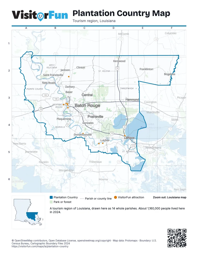
Highway index of Plantation Country
Each highway on the sheet and the grid squares it crosses.
- I-10A3, B3, C3, C4, D4, E5
- I-12C3, D3, E3
- I-55D1, D2, D3, D4
- I-110B3
- I-310D5, E5
- US 51D3, D4
- US 61B1, B2, B3, C3, C4, D4, D5, E5
- US 90D5, E5
- US 190A3, B3, C3
- LA 1B3, B4, C4
- LA 10B2
- LA 22C4
- LA 42C4
- LA 70C4
- LA 73C3, C4
- LA 76B3
- LA 415B3
- LA 964B2
- LA 965B2
- LA 3089C4
- LA 3188D4
Things to do on the Plantation Country map
- 13th Gate Escape
- Baton Rouge National Cemetery
- BREC's Baton Rouge Zoo
- Cajun Pride Swamp Tours
- Godchaux–Reserve Plantation
- Houmas House Estate and Gardens
- L'Auberge Casino & Hotel Baton Rouge
- Laura Plantation
- Louisiana State Capitol Welcome Center
- Louisiana's Old State Capitol
- LSU Hilltop Arboretum
- LSU Rural Life Museum
- Magnolia Wilds
- Mall of Louisiana
- Oak Alley Plantation
- Tiger Stadium
- USS Kidd Veterans Museum
- West Baton Rouge Museum
- West Baton Rouge Tourist Information Center
- Whitney Plantation
Places on the map
- Baker
- Baton Rouge
- Bogalusa
- Central
- Clinton
- Donaldsonville
- Franklinton
- Gonzales
- Hammond
- Jackson
- Kentwood
- LaPlace
- Lutcher
- New Roads
- Plaquemine
- Prairieville
- Saint Francisville
- Zachary
Next to Plantation Country
- Cajun Country map
- Crossroads map
- Greater New Orleans map
- Capital / River
- Mississippi Gulf Coast
- Mississippi Pines
© OpenStreetMap contributors, Open Database License, openstreetmap.org/copyright · Map data: Protomaps · Boundary: U.S. Census Bureau, Cartographic Boundary Files 2024