

Louisiana map
Broussard map
About 15,312 people live here (Census Bureau, 2024 estimate). The sheet's index lists 300 streets; Ambassador Caffery Parkway, Southwest Frontage Road and Southwest Evangeline Thruway cross the most grid squares. Also on it: Broussard Sports Complex at St. Julien Park, Cypress Meadows Commons Area and Oceans Behavioral Hospital Broussard.
Open the map (PDF, US Letter)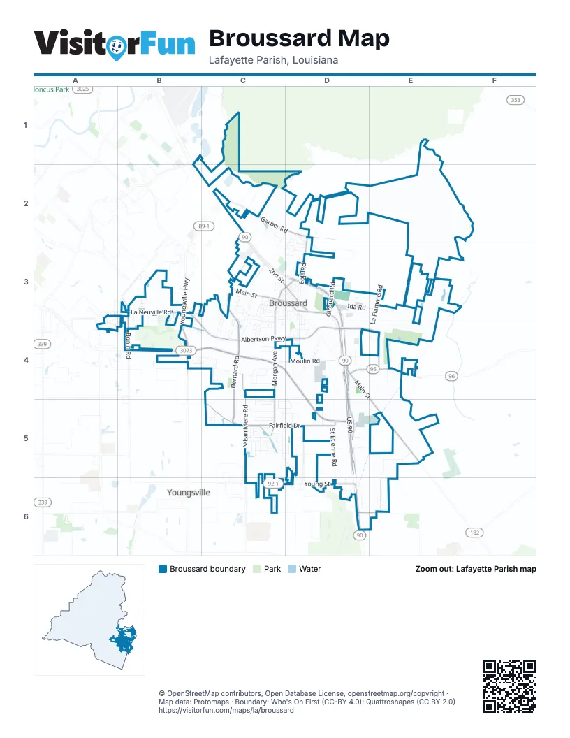
Street index of Broussard
Each street on the sheet and the grid squares it crosses.
- Ambassador Caffery ParkwayB4, C4, D4, D5
- Southwest Frontage RoadC2, C3, D4, D5
- Southwest Evangeline ThruwayC2, C3, D3, D4
- US 90D4, D5
- East Main StreetC3, D3, D4, E5
- Young StreetC6, D6
- Veterans Memorial ExpresswayD6
- Old Spanish Trail Highway NorthE5
- Smede HighwayD6, E6
- South Morgan AvenueC3, C4, C5
- Youngsville HighwayB3, B4
- State Route 96D4, E4
- West Main StreetC3
- West 2nd StreetC3, D3
- North Morgan AvenueC3, D3
- K O L DriveC3
- Terrace HighwayE4
- South Bernard RoadC3, C4, C5
- Albertson ParkwayB3, B4, C4, D4
- St Nazaire RoadD4, E4
- West Fairfield DriveC5
- North Larriviere RoadC4, C5
- Garber RoadC2, D2
- La Neuville RoadB3
- East Fairfield DriveC5, D5
- Bonin RoadC2, B3, B4
- North Eola RoadD2, D3
- Marteau RoadD5
- East 2nd StreetD3
- Saint Etienne RoadD4, D5, D6
- Moulin RoadC4, D4
- Heart D Farm RoadC4
- Lake Talon RoadD5, E5
- St Etienne RoadD4, D5, D6
- Saint de Porres StreetD3, D4
- Deer Meadow BoulevardC5, D5
- Burgess DriveD2, C3, D3
- La Flamme RoadE3, E4
- Ida RoadD3, E3
- Hardware RoadD4, D5
- Hulin RoadC5
- Pear Tree CircleD2, D3
- Easy Rock Landing DriveC5
- Freeman RoadD6
- Sandy Bay DriveC5
- Robicheaux RoadC4
- North Bernard RoadC2, C3
- Tennyson DriveB4, C4
- Vivian DriveB3
- Bayou Tortue RoadE3
- Victoria Lights LaneD4, C5, D5
- Hillbrooke DriveC3, C4
- South Eola RoadD3
- Jared DriveD3
- South Girouard RoadD3, D4
- Ambergris LaneA3, B3, A4
- Stag's Leap LaneC5, D5
- Huval DriveC3
- Loul StreetD3, D4
- Canary Palm WayC5
- 1st StreetC3, D3
- Lantana CourtE4
- North Girouard RoadD3
- West Monroe StreetC3
- Heathwood DriveC3, C4
- Ridgeview DriveC4, D4
- Nellies LaneD4
- Bentwater DriveC3, C4
- Avenue CC3, D3
- Teakwood DriveB4, C4
- Gondron LaneC3
- Still Waters DriveC5
- Lafferty DriveE3
- Millstone RoadD4
- Channel DriveC3, C4
- West Madison StreetC3
- Birchview DriveC5
- Estates LaneC4
- Barksdale DriveC5
- Sugar Trace DriveC5
- Dairy LaneC2, D2, C3
- Misty WInd DriveC5
- Longleaf DriveC4
- Jehnna David DriveC4
- Overbrook DriveC3, C4
- Flambant DriveC3, C4
- Majestic Oaks DriveC5
- South St Pierre StreetC3
- 3rd StreetD3
- Louis Records RoadE6
- Fairwood DriveC3, C4
- Cummings RoadC2
- East Broussard StreetC3, D3
- Nolan RoadC2
- Clara StreetC3
- East Madison StreetC3, D3
- Spanish Moss LaneC5
- Leon StreetD4
- Bercegeay RoadD5, E5
- Commercial ParkwayC3
- East Monroe StreetC3, D3
- Sundown DriveC4
- Masters DriveC3
- Carriage Light LoopB3, B4
- Southeast Frontage RoadD3
- South Jefferson StreetC3
- Windrow DriveC4, C5
- Cane Creek DriveC5
- Mary StreetC3
- Reservoir RoadD4
- North Cruse AvenueD5
- Cason RoadC2
- La Rue MalagaC4
- Wise StreetD4
- Bronze Palm WayC5
- Lexi Falls LaneC4, D4
- McArthur COurtC5
- Cranberry DriveC5
- Regal DriveD3
- West Broussard StreetC3
- Habitat Ridge RoadD4
- Rue de CanneC5
- Springwater DriveC3
- White Sky DriveC5
- Louisa StreetC4
- Gustave StreetD3, D4
- Avenue BD3
- East Railroad StreetC3, D3
- Kelsea DriveC4
- Sweetland AvenueD3, D4
- Dustin CircleC4
- Rue Beau Soleil RoadC5, D5
- Sabal Palms RowC5
- Gentle Island DriveC5
- Old Road DriveC5
- Bayou des Glaises RoadC5
- Seychelles StreetA4, B4
- Amy RoadC3
- Carlo Listi DriveB3
- Hidden Wood DriveB3
- Bismark DriveD2, D3
- Raven Cliff LaneC5, D5
- Flora Springs DriveB3
- Madelyn StreetC4
- Lost Bridge DriveC5
- Park Center DriveC2
- Louis StreetD4
- Old Farm RoadD4
- Carriage Lake DriveB3, B4
- Old Cypress DriveC5
- Abaco LaneA3, B3, A4
- Berrybrook AvenueD3
- Lakeview RoadE5
- South Saint Jean StreetC3
- Brownlee AvenueD3
- Rue NapoleonD6
- Precision DriveC3
- Beau Clos LaneE4
- Rue PapillonD5
- Windy Feather DriveC5
- St Martinique LaneA4
- Marietta DriveB3
- Sugarcreek DriveB3
- Sylvester DriveC5
- Recovery RoadB4
- Coachman DriveB3
- South Lee AvenueC3
- Celebrity DriveD3
- Lockridge DriveC4
- Duke StreetD3, D4
- Patrick DriveC3, C4
- Jenci DriveC4
- Turnmill DriveC5
- Naumann Pvt LaneD4
- Leda BoulevardC3
- Pappa Joe DriveC3, C4
- Angel Rock LaneC5, D5
- Wyatt LaneC5, D5
- South Washington StreetC3, D3
- Sugarfield RoadD5
- Bon Crest AvenueD3
- Phelps DriveB3
- Rue PlaisanceB3
- Ned L StreetD3, D4
- Balboa DriveD3
- Cascade Water LaneC4, C5
- Melissa DriveB4
- Roto Park DriveD3
- Oak Hollow DriveB3
- Trudeau LaneC3
- West Roosevelt StreetC3
- Waterberry DriveC5
- Doe LaneC5, D5
- Amberwood DriveB4, C4
- Oil Patch RoadC2
- Southwood DriveD5
- Knight StreetD3, D4
- Lakeview DriveD5, E5
- Fawn LaneD5
- 4th StreetD3
- Colchester DriveD3
- Meadowbrook DriveC3
- Autumnbrook DriveC5
- Edgewater DriveC3
- Beile RoadE4
- Portsmouth DriveD3
- Terrebone RoadC6
- Wilkie StreetC3
- Sugarland DriveD5
- Glenn StreetC3
- Birdie LaneC2
- Clearview DriveD4
- Merline DriveD3
- Dogleg DriveC3
- Leisure Field DriveC4
- Ivory Palm CourtC5
- Weco LaneD6
- Fleming DriveC3
- Griffin RoadC5
- Ducote DriveC3
- Herbsaint DriveB3
- East Roosevelt StreetC3
- Stanton StreetD3
- Village Sq DriveC4
- Newshire DriveC3, C4
- Truman StreetC3, D3
- Vinewood DriveC5
- Treat DriveC4, C5
- Weeping Willow BoulevardD2
- Aurelien LoopE4
- Devillier RoadC6
- North Saint Jean StreetC3
- Aaron DriveA4
- Delcy DriveD3
- Swaco WayD3
- Copeland DriveC5
- Rattan WayC5
- Tulip Tree LaneD2, D3
- Terrace Oak LaneE4
- Marguerite StreetC3, C4
- West Railroad StreetC3
- Yvonne StreetC3, C4
- Morning Cypress DriveC5
- Oakview DriveD4
- Cypress Sunset DriveC5
- Bluffwood DriveC3, D3
- Weldon DriveD5
- Geology CircleD6
- Windmill Palm LaneC5
- Spike LaneC5, D5
- Bamboo Palm WayC5
- Hanna DriveC4
- Polk StreetC3, D3
- Tiger CourtC5
- Spring Cypress DriveC5
- Grace LaneA3
- Eleanor StreetC3, C4
- Vida DriveD3
- Fallow LaneD4
- North Lee AvenueC3
- Bristow Bayou RoadC5
- Chilton DriveC4
- Foxtail TrailC5
- Shell RoadA4
- Rousseau RoadB4
- Kaiser DriveB4
- Bayberry AvenueD3
- Alley TwoD3
- Paul StreetD4
- Alvin DriveE3
- Campton DriveD3
- South Grindstone DriveC5
- Opa LaneC4
- Saint Barnabas StreetD4
- Royal Palms DriveC5
- Saint Ignatius StreetD4
- Rue CampagneC5, D5
- McNary StreetC3
- Willowview DriveD4
- Caneview DriveD4
- Papershell DriveC4
- Avenue DD3
- Groveland DriveC4
- Howard StreetC3
- Saint Cabrini StreetD4
- South Cruse AvenueD5, D6
- North Jefferson StreetC3
- Gordon Crockett DriveB3
- Heron Point DriveC5
- L H Boulet StreetD6
- West Greenhill CircleE3
- North Grindstone DriveC4, C5
- Inlet DriveC3
- North Saint Pierre StreetC3
- Fabre RoadC6
- Mallorca LaneA4
- Lafayette StreetD3
- South Polk StreetD3
- Alley 1D3
- Hemlock DriveB3
Places on the map
- Acadiana Plumbing Services
- Albertsons
- Arceneaux Park
- AutoZone
- Broussard 10
- Broussard Fire Department
- Broussard Middle School
- Broussard Police Department
- Broussard Sports Complex at St. Julien Park
- Cane Row
- CC's Coffee
- Central Pizza & Bar
- Chevron
- Concession Stand
- Cypress Meadows Commons Area
- Cypress Meadows Pond
- Domino's
- Exxon
- Hampton Inn Broussard-Lafayette Area
- Ida Benoit Crouchet Memorial Park
- Katherine Drexel Elementary School
- Main Street Historic District
- Martial F. Billeaud Elementary
- Murphy USA
- National Discount Tire
- Neighborhood Pond
- Oceans Behavioral Hospital Broussard
- Overbrooke Park/Pond
- Overbrooke Pond
- Parish Brewing Co.
- Parkside RV Park
- Sacred Heart of Jesus Catholic Church
- Safari Train Ride
- Starbucks
- Stine Home + Yard
- The Home Depot
- Walgreens
- Walmart Supercenter
- Waterford Ridge Sidewalk 1
- Zoosiana
Next to Broussard
© OpenStreetMap contributors, Open Database License, openstreetmap.org/copyright · Map data: Protomaps · Boundary: Who's On First (CC-BY 4.0); Quattroshapes (CC BY 2.0)















