

Louisiana map
Houma map
About 31,671 people live here (Census Bureau, 2024 estimate). The sheet's index lists 300 streets; Main Street, Grand Caillou Road and Park Avenue cross the most grid squares. Things to do inside the boundary: Houma Area.
Open the map (PDF, US Letter)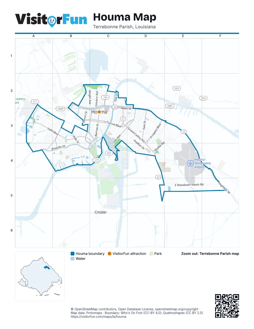
Street index of Houma
Each street on the sheet and the grid squares it crosses.
- Main StreetB2, C2, B3, C3, D3
- Grand Caillou RoadC2, C3, D3, D4, D5
- Park AvenueB2, C2, D2, B3, C3
- New Orleans BoulevardC2
- East Main StreetD3, E3, F4
- New Orleans BridgeC2
- Bayou Black DriveC3, A4, B4, C4
- Barrow StreetC2, C3, B4, C4
- East Tunnel BoulevardC3, D3
- Prospect BoulevardD3, D4
- Highway 56F4, F5
- South Van AvenueC3, D3, C4
- Lafayette StreetC2, B3, C3
- Honduras StreetB3, C3
- Bond StreetB3, C3
- Little Bayou Black DriveB3, C3
- Howard AvenueD3
- West Tunnel BoulevardB3
- North Van AvenueD3
- Beatrice StreetC3
- Valhi BoulevardA3, B3, C3
- Saint Charles StreetB2, B3, B4
- South Hollywood RoadA3
- Polk StreetB2, B3, B4
- East StreetD3
- Civic Center BoulevardB3, C4
- Southdown Mandalay RoadB3, A4
- Industrial BoulevardC4
- East Woodlawn Ranch RoadE5, F5
- Acadian DriveC3, D3, D4
- Crescent BoulevardB3, C3
- Laban AvenueC3, D3, D4
- Dunn StreetC2, C3
- Roussell StreetC2, C3
- Concord RoadB4, C4
- Williams AvenueC2
- Clendenning RoadE3
- Barataria AvenueB3, C3
- School StreetC3
- Mary Hughes DriveD4
- Point StreetC3
- Central AvenueC2, C3
- Morrison AvenueB2
- Verret StreetC3
- Wright AvenueB2, C2
- Saadi StreetC3
- Suthon AvenueC2
- Blimp RoadE3
- San Antonio BoulevardB3, B4
- Amarillo DriveA4, B4
- High StreetB3, C3
- Buena Vista BoulevardB4
- Senator CircleD3
- Church StreetC2, B3, C3
- Maple AvenueC2
- Goode StreetC3
- Port Royal WayA3
- Wilson AvenueC2
- Chantilly DriveA3, B3, B4
- Lancaster DriveA3, A4
- Academy StreetB3, C3
- Roberta Grove BoulevardD3
- Gouaux AvenueC2
- Mystic BoulevardB3
- Grinage StreetC3
- Cougar DriveB4
- Baptiste CircleE4
- Belanger StreetC3
- Magnolia StreetB3, C3
- Tulip DriveB4
- Moffet RoadD3, E3, D4
- Liberty StreetC2, C3
- Harvest DriveB3
- Winfield BoulevardB4
- Tigerlily DriveB4
- Hollygrove AvenueB4
- Levron StreetB3
- Rounds RoadE3, E4
- Engeron StreetC2, C3
- Valhi Lagoon CourtA3
- Division AvenueC3
- Sunset AvenueB3, C3
- Marmande StreetC2, C3
- Wood StreetC3
- Palm AvenueC2
- Mahler StreetC2, C3
- Summerfield DriveB3, A4, B4
- Cummins RoadD4, E4
- Wellington DriveA3, A4, B4
- Taxi RoadE3, E4
- Garnet StreetC2
- Hialeah AvenueD3, D4
- Daspit StreetC3
- Glynn AvenueC3, D3, C4
- Morris StreetC3, D3
- Roselawn AvenueD3
- Cheyenne DriveB3, B4
- Jane AvenueD3, D4
- Dixie AvenueD3
- Southdown West BoulevardA3, B3
- Jean Ellen AvenueD3, D4
- Canal StreetB3, C3
- Carolyn AvenueD3
- Authement StreetD3
- Hawthorne DriveB3
- Mary Ann AvenueD3
- Lee AvenueC3
- Stovall StreetB2
- Boundary RoadD3, D4
- Cleveland StreetC3, D3
- Agnes StreetC3, D3
- Prince Collins AvenueB2
- Keystone LoopB3, B4
- Oak StreetC2
- Peach StreetC2
- Willard AvenueB4
- Mc Kinley StreetB2
- Evelyn AvenueD3, D4
- Angelle DriveA3, B3
- Keeley Ann DriveB4
- Cenac StreetC2
- Lynwood DriveB3, B4
- Pecan StreetC2
- Woodside DriveD3
- Leona StreetC2, C3
- Wayside DriveA3
- Cottage DriveA3, B3
- Payne StreetD3
- Columbus StreetB3
- Country Club DriveC4
- Tulane StreetD3
- Louise StreetC2, C3
- Richmond AvenueD3
- Tower RoadE4
- Hobson StreetB3
- Thunderbird RoadE4
- Bushnell RoadE4
- Elysian DriveD3, D4
- Morgan StreetB2, B3
- Clayton DriveA3, A4
- James RoadD4, E4
- Forest BoulevardB4
- Daralyn DriveE5
- L Kirth DriveE5
- Firwood DriveE5
- June DriveB4
- Windward DriveA3
- Fern StreetB4
- Naquin StreetB3
- Gabasse StreetC2, C3
- Brooklyn AvenueB2
- Duval AvenueC2
- Merrill DriveC3
- Beauregard StreetB4
- 6th StreetC2
- Patterson StreetD3
- Effie StreetC3, D3
- Senator StreetD3
- Meandering WayB3
- F O P CourtD3, D4
- Grande StreetD3
- Jefferson Davis StreetB2, C2
- Raywood DriveB3, B4
- Texas AvenueB4
- Oakdale LoopB3
- Lois RoadC3
- Patriot DriveD4, E4
- Tiger Tail RoadB3, B4
- Aycock StreetC3
- Pendleton DriveA3, B3
- Ellender StreetC3
- Scott LaneB2
- Aspen DriveA3, A4
- South Moss DriveA3, B3
- Walnut StreetC2
- West StreetD3
- Barrios AvenueB4
- Buron StreetC3
- Allen StreetD3
- Paris LaneD4
- Bergeron StreetC2
- Morningside DriveB3, C3
- Memory LaneD3
- Midland DriveB3, B4
- Maxine StreetC3
- Jefferson DriveA3, B3
- Rebecca DriveA3, A4
- Bridgeport WayA3
- Legion AvenueC2
- Birch StreetC2
- Camille StreetA3, A4
- Hackberry AvenueB2, B3
- Connely StreetC2
- Pitre StreetC2
- Oaklawn DriveD4
- Melody DriveD3
- Smith LaneB2, B3
- Plant RoadC3, D3
- East Park AvenueC2
- Sandy Beach RoadB4
- North Moss DriveA3, B3
- Jackson StreetD3
- Judith StreetD3
- Autumn DriveB3
- Glendale AvenueB4
- Apache RoadB4
- Banks AvenueD3
- Rue Saint RachelB3
- Cordell RoadE5
- Glenwood DriveD3
- Sylvia StreetC3
- Antoine StreetB2, B3
- Bobbie Lou AvenueC3, D3
- North Boundary RoadE3
- Wolff ParkwayB2, B3
- Acklen AvenueD3
- South StreetB4
- Wallis StreetC3
- Pear StreetB2, C2
- Nederland DriveA3, B3
- Wise CircleD4
- Margaret StreetC3
- Woodhaven DriveD3
- King StreetD3
- Galvez LaneE4
- Shay DriveA4
- Center StreetC3
- Dupont StreetC3
- Willow StreetC3
- Franklin AvenueB2
- Plum StreetC3, D3
- Brinwood DriveA3
- Taxiary Golf RoadE4
- Hellier StreetC3
- Hancock RoadD4
- Parnell DriveA3
- Myrtle StreetC3
- Fielders CourtC3, D3
- Carthage DriveB3, B4
- Rio Vista AvenueD4
- Samuel StreetD3
- Swan AvenueD3
- Calloway RoadD3, D4
- Coachman DriveA3
- Dewey StreetC3
- Woodwind DriveA3
- Julliette DriveA4
- Aubrey DriveB3
- Saint Peter StreetC3
- Hibernia PlaceD4
- Saint Michel AvenueC2
- Ashlawn StreetD3
- Corpus Christi DriveB3
- Rosemary AvenueD3
- Mary Hughes CircleD4
- Easy StreetB3
- Boykin StreetB2, B3
- Wimberly WayA3
- Laurel DriveA4
- Tulsa AvenueB4
- Afton StreetD3
- Victoria DriveB3, B4
- Folse DriveB4
- Holden CourtB4
- Jim Bowie CourtE5
- Pontiff StreetC3
- General Grant StreetB4
- Lyles StreetD3
- Adoue StreetB2, B3
- Gum StreetC2
- Boudreaux StreetC3, D3
- Safety RoadE4
- Navajo DriveC3
- White StreetB2, C2
- Aviation RoadE3, E4
- Glenmore AvenueD3
- Eliza StreetB3
- Leslie StreetD3
- Kynes RoadE5
- Saint Malo StreetD3
- Arlington AvenueD3
- Austin DriveB4
- Bourg StreetC3
- Camellia AvenueD3
- Frank StreetD3
- Vanessa DriveA4
- Furman StreetC3, D3
- Havers StreetC3
- Myrick DriveA4
- Cherbourg StreetD3
- Coral DriveA3, B3
- Saint Pius StreetC3
- InglewoodA3
- Levee DriveB3
- Ash StreetC2
- Bordelon DriveE4
- Slatter StreetC2, D2
- Windsong WayA3
- Clay StreetC3
- Elizabeth StreetC2
Things to do on the Houma map
Places on the map
- Acadian Elementary School
- Air Base Park
- Annunziata Catholic Church
- Auto Spa
- Auto Spa Express
- Barrios Park
- Burger King
- Cathedral of Saint Francis de Sales
- Chabill's
- Chevron
- Chick-fil-A
- Coastal Urgent Care of Houma
- Courtyard Houma
- CVS Pharmacy# 10885
- Daquiris & Company
- Days Inn by Wyndham Houma LA
- Dollar General
- East Houma Library
- Ellender Memorial High School
- Finding Our Roots African American Museum
- Fishing Area
- Glenn F Pope Memorial Park
- GoBears
- Harmond Park
- Holy Rosary Catholic Church
- Honduras Elementary School
- Houma Christian School
- Houma City Hall
- Houma Historic District
- Houma Police Department
- Houma Post Office
- Houma-Terrebonne Airport
- Jim Bowie Park
- Mulberry Elementary School
- Mulberry Park
- Oaklawn Junior High School
- Summerfield Park
- Terrebonne High School
- Terrebonne Parish Library
- Walmart Supercenter
Next to Houma
- Crozier
© OpenStreetMap contributors, Open Database License, openstreetmap.org/copyright · Map data: Protomaps · Boundary: Who's On First (CC-BY 4.0); Quattroshapes (CC BY 2.0)















