

Louisiana map
Terrebonne Parish map
About 103,864 people live here (Census Bureau, 2024 estimate). The sheet's index lists 300 streets; Highway 56, Bayou Black Drive and West Main Street cross the most grid squares. Things to do inside the boundary: Houma Area.
Open the map (PDF, US Letter)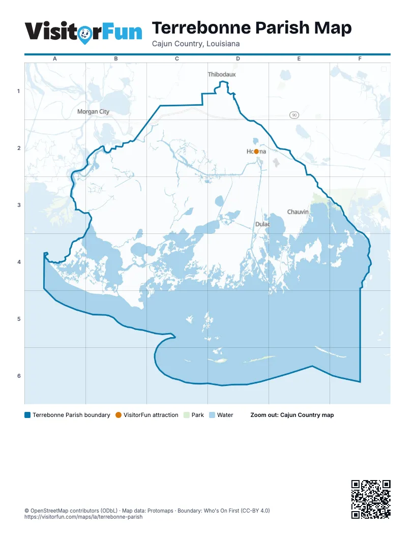
Maps inside Terrebonne Parish
1 map inside, from the street map of Terrebonne Parish down.
Street index of Terrebonne Parish
Each street on the sheet and the grid squares it crosses.
- Raceland-M C ExpressA2, B2, C2
- Raceland-M C ExpresswayA2, C2, D2
- Grand Caillou RoadD3, D4, D5
- Main StreetC1, D3
- Park AvenueC1, D3
- West Main StreetC1, C2, D2, D3
- West Park AvenueC1, C2, D2, D3
- Highway 24C1, D3, E3
- New Orleans BoulevardD2, D3
- East Main StreetD3
- Bourg-Larose HighwayE3
- New Orleans BridgeD3
- Canal BoulevardC1
- Bayou Black DriveA2, B2, B3, C3, D3
- Highway 56D3, E3, E4, D5, E5, D6
- Bayou Dularge RoadD3, C4, D4, C5
- State Highway 55E3, E4, E5
- Bayou Blue RoadC2, D2, D3, E3
- Highway 665E4, F4, F5
- Coteau RoadC2, D2, D3
- Bayou Sale RoadD5, D6
- Little Bayou Black DriveC2, C3, D3
- Prospect BoulevardD2, D3
- West Tunnel BoulevardD3
- East Park AvenueD3
- Martin Luther King BoulevardC2, D3
- South Hollywood RoadC3, D3
- Barrow StreetD3
- East Tunnel BoulevardD3
- North Hollywood RoadD2, D3
- Madison Canal RoadE5
- South Van AvenueD3
- Highway 58E4
- Company Canal RoadE3
- Lafayette StreetD3
- State Route 311C1
- State Route 662A2
- Honduras StreetD3
- Bond StreetD3
- Percy Brown RoadC1
- Julia RoadC1
- Howard AvenueD3
- West Thibodaux by-Pass RoadC1
- North Van AvenueD3
- Beatrice StreetD3
- Highway 316C2
- Saint Bridget RoadC1
- Bayou Gardens BridgeC2
- Bayou Blue BridgeC2
- Sarah RoadE4
- State Highway 3087D2
- Bayouside DriveE3, E4, E5
- North Bayou Black DriveB2, B3, C3
- Shrimpers RowD4, D5
- Southdown Mandalay RoadC3, D3
- Valhi BoulevardC3, D3
- Savanne RoadC2, C3
- Four Point RoadD5, D6
- Falgout Canal RoadC5, D5
- Doctor Beatrous RoadC4, D4, C5
- Country DriveD3, E3
- Aragon RoadE3, E4
- Bayou Gardens BoulevardC2, D2
- Saint Charles StreetD3
- Westside BoulevardC2, D2
- Saint Louis Canal RoadD2, D3
- Westside Boulevard ExtensionC2, C3
- Alma StreetD2, D3
- Lower Country DriveE3
- Back Project RoadC1
- Main Project RoadC1
- Horseshoe RoadC1
- Industrial BoulevardD3
- Enterprise DriveD2, C3, D3
- Corporate DriveC3, D3
- Polk StreetD3
- Bayou Gardens Boulevard ExtensionD2
- Azalea DriveB2
- Old Spanish TrailA2
- Klondyke RoadE3
- Texas Gulf RoadE3
- East StreetD3
- Civic Center BoulevardD3
- Vicari StreetD2
- Brule Guillot RoadB2
- Oakshire DriveC2, D2
- Talbot AvenueC1
- Audubon AvenueC1
- Carroll StreetB2
- Klondyke BridgeE3
- Donut StreetE3
- Smith Ridge BridgeE4
- Blanchard BridgeC3
- Jarvis BridgeB2
- Bullrun RoadB2, C2
- Brady RoadC5
- Island RoadF4, F5
- Crochetville RoadE4
- Deadwood RoadA2, B2
- Geraldine RoadA2
- Hope Farm RoadE3, E4
- Thompson Road ExtensionD3, E3
- Saint George RoadC1
- East Woodlawn Ranch RoadD3
- Isle of Cuba RoadC1
- Acadian DriveD3
- Denley RoadD3
- Express BoulevardD3
- Sonat RoadE4, F4
- Thompson RoadD3
- Point Barre RoadE4, E5
- Vice RoadD4
- Point Farm RoadE4
- Bayou Blue Bypass RoadC1, C2
- Shell E & P RoadB2
- Country Estates DriveD2
- Dickson RoadD3
- Redfish StreetD6
- Broadmoor AvenueD2
- North Main Project RoadC1
- Waterplant RoadC1
- Rue Des AffairesC2
- Bayou Country PkwyC3
- Presque Isle DriveD3
- Humble Canal RoadE4
- Old Bayou Dularge RoadD3
- Crescent BoulevardD3
- Idlewild DriveC2, D2
- Douglas DriveD2
- Laban AvenueD3
- Butcher RoadC1
- Sterling DriveD4
- Bayou Guillaume RoadD4
- Dunn StreetD3
- Ashland DriveD4
- Ouiski Bayou DriveC2, C3
- American BoulevardD3
- Prevost DriveD2
- Roussell StreetD3
- Mire StreetD2
- Kenney StreetD2
- Linda Ann AvenueC2
- South Bayou Black DriveA2, B2
- Equity BoulevardC3
- Venture BoulevardC3
- Concord RoadD3
- Hunley CourtD3
- Willie Lou AvenueD2, D3
- Capital BoulevardC3
- Lumen Christi CourtC2
- Bayou Gardens DriveD2
- Glynn AvenueD3
- Prentice CourtC2
- Funderburk AvenueD2
- Sugar Highland BoulevardC3
- Williams AvenueD3
- Melvin CourtD3
- Gabi CourtC5
- Estate DriveD3
- Benton DriveD3, E3
- Highland DriveD3
- Sugarwood BoulevardC3
- Fohs Canal CourtC5
- Clendenning RoadD3
- Barataria AvenueD3
- School StreetD3
- Mary Hughes DriveD3
- Patrick DriveC1
- Palm AvenueD3
- Exeter RunC3
- Sugar Plum StreetC2
- Sugar Land StreetC2
- Point StreetD3
- Central AvenueD3
- Morrison AvenueD3
- Williams StreetD3
- Verret StreetD3
- Saint Martin LaneC3
- Ashland Landfill RoadD3
- Ringo Cooke RoadC2
- Manchester DriveC3
- Wright AvenueD3
- Jean CharlesC1
- Saadi StreetD3
- Suthon AvenueD3
- Blimp RoadD3
- Cedar Grove RoadD4
- Devil Swamp RoadC1
- Holiday DriveD2, D3
- San Antonio BoulevardD3
- Monarch DriveD3
- Levron StreetD3, E4
- Amarillo DriveD3
- Marietta PlaceC2
- High StreetD3
- Mozart DriveD3
- Buena Vista BoulevardD3
- Old Schriever HighwayC1
- Senator CircleD3
- Church StreetD3
- Powhattan CourtA2
- Maple AvenueD3
- Goode StreetD3
- Port Royal WayC3
- Roland RoadD3
- Cross StreetE4
- Louis DriveD2
- Wilson AvenueD3
- Chantilly DriveD3
- Lancaster DriveC3, D3
- Academy StreetD3
- Cascade DriveD2, D3
- Tou Lou Lou StreetD6
- Wood StreetD3, E3, E4
- Harding DriveD2
- Westview DriveD2
- Roberta Grove BoulevardD3
- Blakefield DriveC1
- Gulf Island Fab CourtD3
- Oak StreetB2, D3, E4
- Gouaux AvenueD3
- Mystic BoulevardD3
- Lafayette Woods BoulevardD3
- Marina DriveB2, D6
- Friendswood DriveD3
- Clinton StreetE4
- Dean CourtD3
- Judith StreetD3, E4
- Grinage StreetD3
- Collins StreetD2
- Industrial Avenue AD3
- South Waterplant RoadC1
- Cougar DriveD3
- Baptiste CircleD3
- Waterfront DriveD6
- Belanger StreetD3
- Diana StreetB2
- Daneco CourtC3
- Mobile Estates DriveC2
- Gaynell DriveD2
- Magnolia StreetD3
- Tulip DriveD3
- Ducros RoadC1
- Little Coteau RoadD2, D3
- Moffet RoadD3
- Liberty StreetD3
- Harvest DriveD3
- Winfield BoulevardD3
- Tigerlily DriveD3
- Rue de la MansonC3
- Rue RichardC2
- Hollygrove AvenueD3
- Rounds RoadD3
- Engeron StreetD3
- Valhi Lagoon CourtC3, D3
- Carlos StreetD3
- Menard RoadD3
- Verna StreetD2, D3
- Caillou Boca CourtD4
- Antil DriveB3, C3
- Maplewood DriveD2
- Division AvenueD3
- Sunset AvenueD3
- Marmande StreetD3
- North American CourtD3
- Chabert RoadE4
- Lynn StreetC1, E4
- Mahler StreetD3
- Broadway AvenueC1
- Oak Alley DriveC2
- Pugs CourtD3
- Summerfield DriveD3
- Lirette StreetC3
- Technology LaneC2
- Darlene StreetC2
- Trinity LaneC2
- Al Joseph LaneC1
- Cummins RoadD3
- Bailey LaneB2
- Highridge DriveD4
- Southwood DriveD2
- South Ja Mon CourtE3
- Nottingham TrailC3
- Southland CircleD2
- Cortez StreetC1
- Rebeccas Pond RoadC2
- Lansdown DriveC3
- Crozier RoadD3
- Wellington DriveC3, D3
- Taxi RoadD3
- Garnet StreetD3
- Sunny Acres StreetE4
- Hialeah AvenueD3
- Gary LaneE3
- Lincoln StreetC2, D2
- Royce StreetC2
- Daspit StreetD3
- Frontage Road AC2
- Hanson DriveC3
- Alice CourtC1
Things to do on the Terrebonne Parish map
Places on the map
- Ashland Sanitary Landfill
- Bay Banan
- Bay Couteau
- Bay Junop
- Bay Long
- Bay Voisin
- Bayou Cane
- Bayou Lacache
- Bayour Country Sports Park
- Caillou Lake
- Camp
- Carencro Lake
- Chauvin
- Dulac
- Ellendale Country Club
- Falgout Canal
- Fourleague Bay
- Goose Bay
- Gray
- Houma
- Houma-Terrebonne Airport
- Humble Canal
- Isle de Jean Charles
- Isles Dernieres Barrier Islands Refuge
- Jug Lake
- King Lake
- Lake De Cade
- Lake Gascha
- Lake Hackberry
- Lake Haumas
- Lake Mechant
- Lake Pagie
- Lake Penchant
- Lake Theriot
- Lost Lake
- Marmande Airport
- Montegut
- Mulberry Cemetery
- Pointe aux Chenes State Wildlife Management Area
- Raccoon Island
Next to Terrebonne Parish
© OpenStreetMap contributors, Open Database License, openstreetmap.org/copyright · Map data: Protomaps · Boundary: Who's On First (CC-BY 4.0); Quattroshapes (CC BY 2.0)















