

Louisiana map
Minden map
About 11,195 people live here (Census Bureau, 2024 estimate). The sheet's index lists 300 streets; Country Club Circle, Industrial Drive and Germantown Road cross the most grid squares. Things to do inside the boundary: Dorcheat Historical Association and Museum.
Open the map (PDF, US Letter)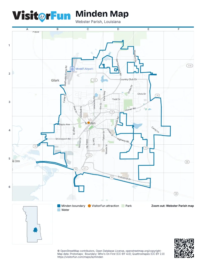
Street index of Minden
Each street on the sheet and the grid squares it crosses.
- Homer RoadC3, D3, E3
- Sibley RoadC4, C5
- Shreveport RoadB4, C4
- Lee StreetC4, C5
- Highway 80B4, D4, E5
- Broadway StreetC3, C4
- Main StreetC3, C4
- East & West StreetC3
- Sheppard StreetC4, D4
- East Union StreetC4, D4
- Lewisville RoadC3, C4
- West Union StreetC4
- State Route 531E6
- Country Club CircleC2, D2, E2, E3
- Industrial DriveC5, C6, D6, E6
- Germantown RoadD1, D2, C3, D3
- Pine StreetB3, C3, C4
- Bayou AvenueB4, C4
- South Talton StreetD4, C5, D5
- Fincher RoadD3, D4
- Weston StreetB4
- Goode AvenueC3, D3
- Tillman DriveC3
- Claiborne StreetD3
- Clerk StreetC3
- Elm StreetC3
- Carolina StreetC5
- Kennon StreetD3
- Washington StreetC3
- West Todd StreetC3
- Dorcheat RoadB2, B3
- McArthur DriveC3
- East Todd StreetC3, D3, E3
- East StreetC4, C5
- Southridge DriveD3, E3, D4, E4
- High StreetB4, C4
- Goodwill StreetC3, C4
- Chris DriveE3
- Horton StreetC4, B5, C5
- Ridgewood CircleD4, E4
- Park HighwayD3
- Constable StreetC3
- Drake DriveD2, D3
- Braeburn Glen DriveC2
- Gladney StreetD3
- Deerfield BoulevardD4, D5
- Joel StreetC4, C5
- Carey LaneE4
- Fort StreetD3, D4
- West StreetB4, C4
- Davenport DriveB5, C5
- Madison AvenueD3
- Marshall StreetC3
- Erwin Thompson DriveB4, B5
- Louisiana AvenueD3
- Martin Luther King DriveC4, D4
- Drew LaneD3
- Woodard DriveE1, E2
- Pennsylvania AvenueC3, D3, C4
- Lakeshore DriveC3
- McIntyre StreetC3, C4
- South Tanglewood DriveC2
- Methodist Camp RoadB2, B3
- Summit StreetC3, D3
- Camp StreetB3
- Chrislo DriveE3
- Woodhaven DriveC2
- Parish Road 126BD2
- North Tanglewood DriveC2
- Hinton StreetD3, E3
- Patrick StreetD3, D4
- Durwood DriveC4, C5, D5
- KCS DriveC4, C5
- Longleaf DriveE2
- Whispering Pines DriveE2, E3
- Pershing StreetC5
- Columbia StreetC5
- Peach StreetC4, D4
- Winford StreetB4
- Woods StreetD4, D5
- Cherry StreetC4, C5
- Pecan View DriveC3
- Cline StreetD3
- Jo Ann LaneE4, F4
- Chandler StreetC3
- Richard's WayE4
- Guy Miller RoadD2
- Clay StreetB5, C5
- Watterman StreetB5, C5
- Yale StreetB4, B5, C5
- Forest DriveE2, E3
- Center StreetC3
- South Ash StreetC3
- Abney StreetC4
- Gloria DriveD3
- Nella StreetD3
- South Fairview StreetB4, B5
- South Middle Landing RoadB4, B5
- Eames StreetD3, E3
- Plum StreetD4
- Crichton StreetB4, C4
- Emerald DriveC3, D3
- Victory DriveD3
- Jackson StreetC4, C5
- Davis StreetC3, D3
- Mignon StreetC4, D4
- Ida StreetD4
- Normandie LaneE4, F4
- Dianne StreetD4
- Walker LaneC2
- Dixie StreetC4
- Long StreetC4
- Dogwood DriveE2
- Rebecca StreetB4
- Pine Forest DriveE2
- Brenda CircleB3
- Brackin StreetC3
- Harris StreetD4
- Morris DriveD3, D4
- US Ford PrivateD2
- Auction Barn RoadB3
- McMullen StreetC5, D5
- Pine Hills DriveD3
- Parkway StreetC4
- McArthur StreetC3
- North Elm StreetC3
- Walnut StreetD4
- Bonnie LaneC3
- Berry DriveC3, D3
- Ellis DriveC3
- Sunset LaneD4
- Crestview DriveC3
- Spann StreetC4, D4
- Cox LaneB4
- Morrow StreetB4
- Post Oak LaneE2
- Rephant StreetC4
- West R Reeder StreetB4
- Bymo DriveD3
- South Gum StreetC4
- Loop RoadC3
- Webster AvenueB4
- Murrell StreetC4
- Pearl StreetC4
- B F Martin DriveD4
- Lillian StreetD3
- McDonald StreetC3, C4
- Walter Lyons RoadB3
- US Ford DriveD2
- North Talton StreetC4, D4
- Robertson DriveB5
- Theus StreetC4
- Buchanan StreetC3
- Boland StreetC5
- Jefferson StreetC3
- Magnolia StreetB4
- Myers StreetC5
- Juniper LaneD4, D5
- Shirley DriveC3
- Chestnut StreetC4
- Midland StreetC4
- South StreetC4
- Bailey StreetC4
- Willow Creek DriveD4
- Apple StreetB4
- Searles StreetC4
- North Middle Landing RoadB4
- North Fairview StreetB4
- Murry DriveE2
- Highland StreetD3
- Richardson StreetC3, C4
- Marion StreetC5
- Bridwell StreetC3, D3
- Babb CircleB5
- Azalea StreetB3
- South College StreetC4
- Milton StreetB4, B5
- Commerce StreetB5
- Ewell StreetD4
- North Monroe StreetC4
- Moore StreetC4
- Miller StreetC4
- Justice StreetC3
- 4th StreetC4
- Alexander StreetB3
- Chrysler StreetC4
- Gum StreetC4
- Plateau StreetC4
- Ryan's WayD6
- Burns Wood TrailE2
- District DriveC4, C5
- Lynn StreetD4
- Deer Creek LaneE2
- Sullivan StreetC3
- Webb CourtC3
- Roy StreetC3
- Angelee StreetC4
- Britt StreetD3
- Bay Creek RoadC3
- McCausland StreetB4, C4
- South Randall StreetB4, B5
- Council StreetC3
- Virginia AvenueC3
- Rathbun StreetD3
- Evergreen DriveE2, E3
- Lumpkin StreetC5
- Young StreetC5
- Gymnasium DriveD4
- South Roosevelt DriveB4
- Ballpark DriveE4
- Barbara DriveB5
- Lewis StreetC4, C5
- West Roosevelt DriveB4
- Harvey's WayD6
- Fulton StreetC5
- Wright DriveC4, D4
- Graveyard StreetD4
- Gleason StreetC4
- Millard Fuller RoadB3
- Austin StreetD4
- West J Beck RoadD5
- College StreetC3, C4
- Fort AvenueC3
- Mark DriveD3
- Woodard StreetD4
- Oak Knoll StreetC3
- Sanders DriveE2
- Shaw DriveC5
- Colten DriveC5
- Franklin StreetD3
- Howard StreetC3
- Beck StreetC3
- Beech StreetD3
- George StreetD4
- Tatum StreetD3
- Penn DriveC3, D3, D4
- Kitchens CourtC2
- South Monroe StreetC4
- 3rd StreetC4
- Holley StreetE2
- Reynolds StreetB4, C4
- Devereaux StreetB4, C4
- Hickory DriveE2
- Hackett DriveC3, D3
- South Abney StreetC4
- Quarles StreetB4, C4
- Thompson DriveB5
- Brice CircleD3
- Buck StreetC4
- Hillside LaneD6
- Meadow LaneD2
- Church StreetD4
- Brooks AlleyC4
- Howell StreetC3
- Mason AlleyC4
- Colony LaneD2
- Hall StreetC4, D4
- Chevrolet StreetC4
- Flournoy DriveE6
- Kirby PlaceC3
- Peach AlleyC4
- Bell StreetB3
- Campbell StreetB4
- Warren StreetD4
- Watts CircleB4
- Fleming LaneD3
- Oakland StreetB4
- Police StreetC3
- Hardy StreetD4
- Dawson StreetB4
- Seminary LaneE3
- Timberline DriveE1
- Bryan StreetD3
- Norton StreetC3
- Sterling StreetB3
- Front StreetC4
- Plymouth StreetC4
- Dennis DriveC4
- Hill StreetD4
- Ferguson StreetC3
- Dodge StreetC4
- Leary StreetC4, D4
- Sylvan PlaceC3, C4
- J A Phillips StreetD5
- Linden StreetC5
- 2nd StreetC4
- Watson DriveE2
- 1st StreetC4
- Gin RoadC4
- Bradford StreetB4
- Whitlock StreetB3
- Garland StreetD3
- Margaret PlaceD2
- Baker StreetD3
- Meadowview DriveD3
- Gilbert StreetC4
- Lanning StreetC3
- Pine Forest CircleD2, E2
- Murdock StreetD4
- Anderson StreetB4
Places on the map
- Academy Park Sign
- Ace Hardware
- Advance Auto Parts
- Babb Park
- Best Western Minden Inn
- Bobby's Hobby's
- Bon Temps
- Brookshire's
- Buffington Veterinary Hospital
- Central Fire Station
- Chad's Auto and Exhaust
- Circle K
- City Park
- CVS Pharmacy #5345
- Dollar General
- Dorcheat Historical Museum
- E. S. Richardson Elementary School
- East Union Shopping Center/Strip Mall
- Eastside Missionary Baptist Church
- El Jimador
- Emannuel Baptist Church
- Ewell Park
- Garden of Memory Cemetery
- Gladney Street Field
- Jones Memorial Public Library
- Love's Travel Stop
- Minden Airport
- Minden Cemetery
- Minden City Hall
- Minden Fairgrounds
- Minden High School
- Minden Medical Center
- Minden Public Library
- Minden Recreation Complex
- Pine Hills Gold Course
- Shepard Street Cemetery
- Turners Pond
- Webster Junior High School
- Webster Parish Library & Stewart Center Sign
- Webster Parish Library Sign
Next to Minden
- Dixie Inn
- Gilark
- Pace
© OpenStreetMap contributors, Open Database License, openstreetmap.org/copyright · Map data: Protomaps · Boundary: Who's On First (CC-BY 4.0); Quattroshapes (CC BY 2.0)















