

Louisiana map
Webster Parish map
About 35,184 people live here (Census Bureau, 2024 estimate). The sheet's index lists 300 streets; Highway 371, Main Street and Highway 80 cross the most grid squares. Things to do inside the boundary: Dorcheat Historical Association and Museum.
Open the map (PDF, US Letter)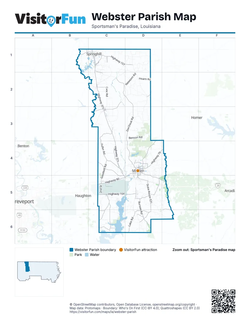
Maps inside Webster Parish
1 map inside, from the street map of Webster Parish down.
Street index of Webster Parish
Each street on the sheet and the grid squares it crosses.
- Powell, Barnes, and Deal Memorial HighwayE5
- Highway 371C1, C2, C3, C4, C5, D5
- Highway 80D4, C5, D5, E5
- State Route 160C2, C3
- Highway 79D4, E4
- South Main StreetC1, C2, D5, D6
- North Main StreetC1, C2, D5, D6
- Main StreetC1, C3, D4, C5, D5
- South Arkansas StreetC1
- General McArthur RoadC5
- Homer RoadD4
- Sibley RoadD4, D5
- Lee StreetC1, D4, D5
- Shreveport RoadD4
- Broadway StreetD4
- Rue North ArkansasC1
- East & West StreetD4
- North Arkansas StreetC1
- State Route 531D5, D6
- Highway 164C5, D5
- Highway 157B1, C1, D1
- State Route 163C5, C6
- Highway 528C4, C5
- Goodwill RoadC4, C5
- State Route 532D5
- Highway 527C6
- Church StreetC2, C3, D4
- Reynolds StreetC1, D4
- Fuller StreetD4, C5
- Porterville RoadC1, C2
- State Route 792D6
- Plain Dealing RoadB1, C1
- Sheppard StreetD4
- State Route 521D2
- East Union StreetD4
- Lewisville RoadD4
- 15th Street NorthwestB1
- Butler StreetC1
- Parish Road 10D5
- Humble AvenueC3
- Resident StreetC3
- West Union StreetD4
- Bellvue RoadC5
- Dorcheat RoadD2, D3, D4
- Fuller RoadC3, C4
- Germantown RoadD3, D4
- Doc Steed RoadC4
- Fire Tower RoadC2, D2
- Lake RoadD6
- Burson RoadD5, D6
- Nursery RoadD5
- Country Club CircleD4
- Tillman Church RoadD6
- Harold Montgomery RoadC6
- Industrial DriveD5
- Pine StreetC1, D4, C6
- Spurgin RoadC5, C6
- Black Lake Bottom RoadE5, E6
- Percy Burns RoadC1
- Gifford Hill RoadC4
- Bayou AvenueD4
- Henrietta White BoulevardC1
- Fincher RoadD4
- Claiborne StreetD4, D5, C6
- Elm StreetC1, D4
- South Talton StreetD4, D5
- Parish Line RoadC6
- Mason Felts RoadD6
- Weston StreetD4
- Goode AvenueD4
- Tillman DriveD4
- Washington StreetC1, D4
- Clerk StreetD4
- West Church StreetC1
- Carolina StreetD5
- Camp Zion RoadC6
- Kennon StreetD4
- East Church StreetC1
- Montgomery DriveB1
- West Todd StreetD4
- McArthur DriveD4
- Franklin RoadC6, D6
- Evergreen RoadD2, D3
- Sand Plant RoadD5, E5, D6, E6
- Cvoc RoadC2
- Blue Run RoadD3, D4
- Dogwood TrailD4, E4
- Marathon RoadC3
- Rodney Martin RoadC2, D2
- Pilgrim Rest RoadC5, C6
- Benson RoadC1, D3
- Walnut RoadC1, C2
- Harveys Barber Shop RoadD5, E5
- Newsom RoadD2
- King Orchard RoadC1, C2
- Haynes RoadC1, D1, D4
- Hearn RoadD2
- Old Arcadia RoadD4, E4
- Peachtree RoadD5, E5
- Sand Hill RoadD1
- Middle RoadD4, C5, D5
- Pruitt RoadD3
- Jack Martin RoadD4, D5
- Saltworks RoadD5, C6, D6
- Penal Farm RoadD5
- Almond CircleD4, E4
- Java RoadC5
- Johnson StreetC5, D5
- Couchwood RoadC3, C4
- Stuckey RoadD5, E5
- Coussons RoadD5, D6
- Baker RoadD1
- Adkins RoadC3
- Methodist Camp RoadD4
- Old Highway 7C3
- Caney Lake RoadD4
- Dement RoadC6
- Mims RoadD3
- Miller RoadD4
- Yellow Pine RoadC6, D6
- Syrup Mill RoadC5
- Allen DriveD4
- Mims Grocery RoadD6
- McIntyre RoadC4, C5
- Magnolia Camp RoadC3
- Voie MimosaC1
- 2nd StreetC2, D4, C5
- Woodmill RoadD6
- Wiley RoadC2, D2
- Greene RoadC4
- Hill Top RoadC1
- Carter RoadC1, C6
- Diamond T RoadC6, D6
- Timothy Church RoadB1
- Ted Riser RoadD6
- Kings Corner RoadC1
- 3rd StreetC1, D4, C5
- Springhill Airport RoadC1
- Fuller Cemetary RoadD4, D5
- Central School RoadD6
- Angi RoadD3
- Bud Lee RoadC1, D1
- Lyons RoadD6, E6
- Chemin Spring BranchC1
- Pisgah RoadD3
- Wise RoadC1, D1
- Ponder RoadC1, C2, D5
- Evergreen School RoadD3
- Cox RoadC2, C3
- Frontage RoadC5
- Teutsch RoadC2, D2
- Old Sarepta Church RoadC2
- Oil Tank RoadD5
- Martha Woods RoadD6
- Sand Plant Cut Off RoadD5, E5
- Cook Baker RoadC1, C2
- Crow Lake RoadC2
- Machen DriveC1
- Crichton RoadD5
- Loyd Whitaker RoadD2
- Wortham RoadD2
- Buddy Brown RoadC4, D4
- Elmer Moore RoadD2
- Bistineau Line RoadD6
- Alvin Miller RoadD4, E4
- Frazier RoadC2, D5
- Denmon RoadC2
- Cockrell RoadD1, D2
- Thomasville RoadC2
- Amos Cutoff RoadC5
- Foreman RoadC5
- Clearmeadow RoadC4
- Booth Cutoff RoadC5, C6
- Sexton RoadD3
- Forest Service Road 814D4
- Boothville RoadC6
- Sand Pit RoadD5
- Parish Road 268C2, C3
- Horseshoe LoopC5, D5
- Cliff Keen RoadD3
- Henry Williams RoadD2
- Shadows LaneD5
- Muddy Bottoms DriveB1, C1
- Elmo Burton LoopC4
- Shiloh RoadC5
- Columbia Road 221C1
- Carroll LaneD5
- Airport RoadC1, D4, D5
- Upper Oil Field RoadD5
- Bill Lockey RoadC2
- Gorton RoadC6
- Mill Pond RoadB1, C1
- Modisette RoadD1
- Neely Camp RoadC2
- College StreetC1, C3, D4, C5
- Lorex RoadC4, D4
- Bennett RoadC2
- East StreetC3, D4, D5
- Burrow LaneC3
- Moores Cemetery RoadD6
- Caney LakeD4
- Smithville RoadC1
- Bataan AvenueC5
- Kennon Pit RoadD6
- East RoadC1
- Hilburn RoadC2
- Chemin Percy BurnsC1
- Moss Point RoadC6
- Central School LoopD6
- 1st StreetC2, D4, C5
- East Todd StreetD4
- Willis Field RoadC5
- Dixie Fomby RoadD1
- Parkside LandingC6
- Bounds RoadC4
- Couchwood Cutthru RoadC3
- Westfield RoadD5, D6
- Tadpole RoadC5
- Pearl Harbor AvenueC5
- Plum Orchard RoadC6
- Spruce RoadD2
- C V Airport RoadC2, C3
- Brushwood DriveD5
- Cowboy Morgan RoadD1
- Haynes Cemetery RoadD1
- 4th StreetD4, C5
- Barry Slack RoadD1
- Lower Oil Field RoadD5
- New Saltworks RoadC5, D5
- 14th Street SouthwestB1, C1
- Mike Pope RoadD1
- Harvey LoopC1, D5
- Miller Briarwood RoadC6
- Chemin WillowC1, D1
- Bill Martin RoadC2, D3
- Aubrey Beatty RoadD6
- Frye RoadC1
- Moore StreetC1, D4
- Harold Montgomery CrossingC6
- Vander Almond RoadD4
- Rice RoadC4
- Victory RoadC5
- Art Camp RoadC6
- Baker StreetC1, D4
- Bistineau Church RoadD6
- Bellevue RoadC3
- Rainey RoadB1, B2
- 11th Street NortheastC1
- Hanson DriveC5
- John Pope RoadD1
- Blocker Chapel RoadC1
- Sportsman Paradise RoadC6
- Ashley RoadC3, C4
- Martin Luther King DriveC1, D4
- Sawmill RoadD5
- Willis RoadC5, D5, D6
- George Taylor RoadC1
- Pitts RoadB1
- Langley RoadC2
- Sikes Ferry RoadC2, C3
- Bertha Washington RoadD3
- Freight Entrance RoadC5
- Johnson RoadC6
- 7th Street SoutheastC1
- Holomon Cemetery RoadD5, E5
- Lone Oak LaneD5
- State Park RoadC6
- Louisiana AvenueD4, C5
- Parish Road 138AD5
- Southridge DriveD4
- Childs RoadD3
- Claude Cox RoadD2
- Brunson RoadD6
- Lakeview DriveC6
- Adams RoadC4
- Coty LaneC5
- Gravel PittD1
- Voie Red BudC1
- John Shaw RoadD2
- Southeast 5th AvenueD5
- Payne StreetC1
- Millwood LoopD5
- High StreetD4
- Junior Edwards RoadC6
- Point RoadC6
- Red Hill RoadD3, D4
- Whispering Pines TrailD4
- Chambless RoadC1, C2
- Elton Wise RoadD1
- Tram RoadC3
- Walker LaneC3, D4
- Boy Scout RoadD4
- Brumley RoadC2, C3
- Goodwill StreetD4
- Stonewood RoadC3, C4
- Coyle StreetC1, C2, C3
- Katie LaneD4
- Buttonwood RoadD6
- Leton Cutoff RoadD2
- Holomon LoopD5, E5
Places on the map
- Babb Park
- Big Mound
- Bull Hill
- Caney Lake
- Caney Lakes
- Caney Lakes Unit (Kisatchie National Forest)
- Central Elementary School
- Cinnamon Creek RV Park
- Cotton Valley
- Cullen
- Cullen City Hall
- Dixie Inn
- Dorcheat Pond
- Doyline
- Dubberly
- Duncan Hill
- Eagle Lake
- Ewell Park
- Garden of Memory Cemetery
- Gladney Street Field
- Hallmark Village
- Heflin
- Indian Mound
- Jones Memorial Public Library
- Lake Bistineau
- Lake Bistineau State Park
- Louisiana Army Ammunition Plant
- Minden
- Minden Airport
- Minden Recreation Complex
- Muddy Bottoms ATV & Recreation Park
- Pine Hills Gold Course
- Sarepta
- Shongaloo
- Sibley
- Springhill
- Springhill Airport
- The Links
- Upper Caney Lake
- Williams Lake
Next to Webster Parish
- Arcadia
- Benton
- Haughton
- Homer
- Shreveport map
© OpenStreetMap contributors, Open Database License, openstreetmap.org/copyright · Map data: Protomaps · Boundary: Who's On First (CC-BY 4.0); Quattroshapes (CC BY 2.0)















