

Louisiana map
Slidell map
About 28,440 people live here (Census Bureau, 2024 estimate). The sheet's index lists 300 streets; Gause Boulevard West, Front Street and Slidell Avenue cross the most grid squares. Things to do inside the boundary: Lodge Cast Iron Factory Store and NOLA Zydeco Fest.
Open the map (PDF, US Letter)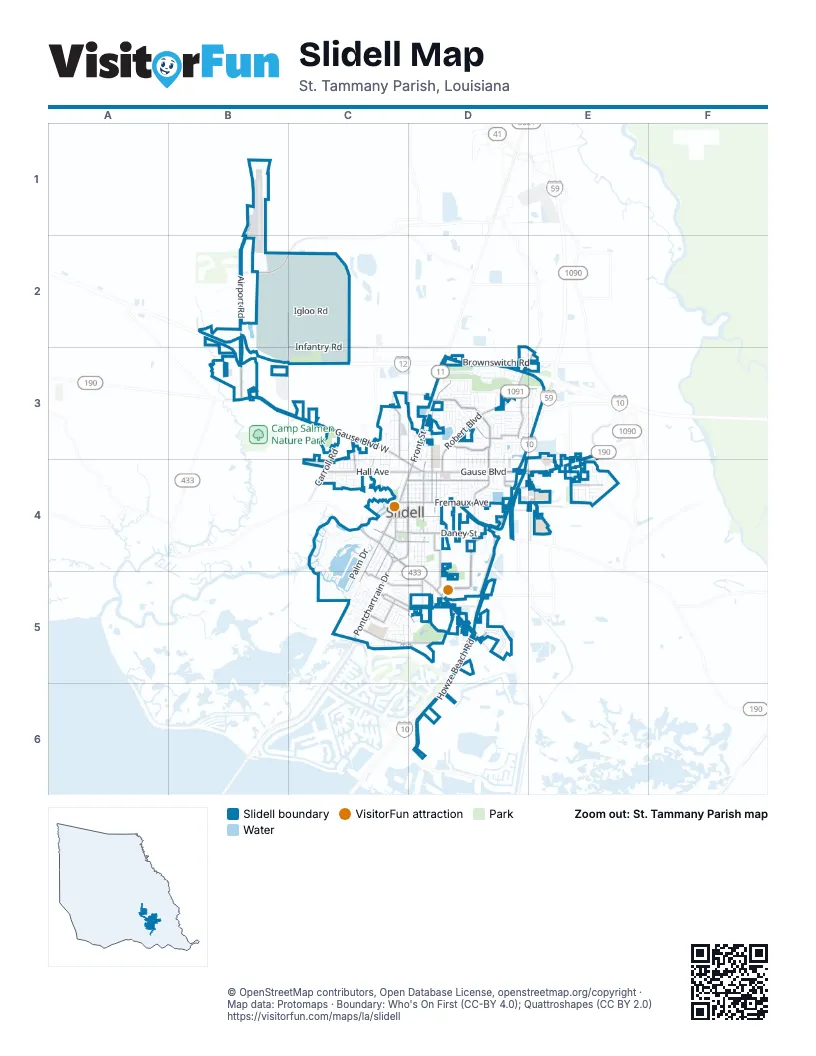
Street index of Slidell
Each street on the sheet and the grid squares it crosses.
- West Florida Republic ParkwayB3, C3, D3
- Old Spanish TrailC4, D4, D5
- Gause BoulevardD4, E4
- Gause Boulevard WestB3, C3, C4, D4
- Front StreetD3, C4, D4, C5
- Airport RoadB1, B2, B3
- Pontchartrain DriveC4, C5
- Northshore BoulevardB3
- Robert BoulevardD3, E3, D4
- Fremaux AvenueC4, D4
- Gause Boulevard EastE3, E4
- Shortcut HighwayD4
- Sergeant Alfred DriveC4
- Doctor T J Smith Senior ExpresswayB2
- 3rd StreetC4
- Bayou Liberty RoadC4
- Airport Road ConnectorB2
- Town Center ParkwayD4, D5
- Spartan DriveC5, D5
- Howze Beach RoadD5, D6
- North BoulevardD3
- 9th StreetD3, D4
- East I- 10 Service RoadE3, D4, E4
- West Hall AvenueC4, D4
- Brownswitch RoadD3, E3
- Florida AvenueC4, D4
- I-10 Service RoadD4, D5
- Independence DriveD3
- Lindberg DriveD4
- Carey StreetC4, C5
- Daney StreetD4
- 7th StreetD4
- Kostmayer AvenueC5, D5
- Grafton DriveD3, E3
- Audubon DriveD3
- Infantry RoadB2, C2
- Rue RochelleD3, D4
- North Carnation StreetC3
- 10th StreetD4
- Cleveland AvenueC4, D4
- Engineer RoadB2, B3, C3
- Cousin StreetC4, D4
- Terrace AvenueD4, D5
- Cardinal DriveD3
- East Howze Beach RoadD6
- Lakewood DriveD4
- Frontage RoadB2, B3, D4
- Lopez StreetD5
- Westchester PlaceC5
- Breckenridge DriveE4
- Maris Stella StreetC3, C4
- Pearl Acres RoadE4
- South Perimeter RoadB3
- Olive DriveC5, D5
- Tyler StreetE4
- Hickory DriveC5, D5
- Oxford StreetC5
- Ben Thomas RoadC3, D3
- Voters RoadD5
- City DriveD5
- Cross Gates BoulevardE3
- Yaupon DriveE4
- Carroll RoadC3, C4
- Caruso BoulevardD5
- Carol DriveE4
- Natchez DriveD4, E4
- Beth DriveD4
- Peachtree StreetD5
- Guzman StreetC4, D4
- Broad StreetC5
- Nellie DriveD4
- Lawes StreetD4
- East Hall AvenueD4
- Taos StreetD4
- Indiana AvenueD3
- Grantham College DriveB2
- Hoover DriveE4
- East Pinewood DriveD3
- Coast BoulevardD5
- Ash StreetD4
- North Harrison RoadC3
- North Pearl DriveE4
- Albert StreetD5
- North Holiday DriveE4
- Brownsvillage RoadC2
- Oak Harbor BoulevardC5
- Country Club BoulevardD3, E3
- Rue MiramonD4
- Driftwood CircleD3
- 4th StreetD3, D4
- 8th StreetD3, D4
- Bonfouca DriveC4, C5
- Bayou LaneC4
- Camellia DriveC4, C5
- Pennsylvania AvenueC4, D4
- 6th StreetD4
- 5th StreetD3, D4
- 11th StreetD4
- 2nd StreetC4
- Canulette RoadC4
- Michigan AvenueC4, D4
- Kensington BoulevardD3, D4
- Markham DriveC5, D5
- College StreetC4, C5
- North Magnolia StreetC3
- Oriole DriveD3
- Spartan LoopC5
- Igloo RoadB2, C2
- William Tell StreetC4, C5
- West Pinewood DriveD3
- Tanglewood DriveD3, E3
- Maine AvenueC4, D4
- Saint Christopher StreetC3, C4
- Eastwood DriveD4
- Teddy AvenueC4, D4
- Englewood DriveD4
- Park DriveD4, E4
- Sunset DriveB2, C3, C4
- Saint Tammany AvenueC3, C4
- Riviera DriveB2, C5
- Eastridge DriveD4
- Crescentwood LoopD3
- Fountain DriveD3
- Constitution DriveD3
- Dale DriveD3, D4
- North Pine StreetC3
- South Palm DriveC4, C5
- Cawthorn DriveD3
- Westlawn DriveC4
- Rama StreetD5
- Corporate Square DriveD4
- Berkley StreetC5
- Broadmoor StreetD4
- Slidell AvenueC4, D4, C5, D5
- Transportation RoadB2
- Medical Center DriveE4
- Addis StreetD3
- North Artillery RoadC2
- Washington AvenueD4, D5
- West Artillery RoadC2
- East Artillery RoadC2
- North Palm DriveC4, C5
- Lincoln AvenueD4
- Hailey AvenueC5, D5
- Tidewater DriveD3, E3
- Levis LaneD4
- Arrowhead DriveC5
- Mary DriveC4, D4
- Effie StreetC4, C5
- Timberlane DriveD3
- Melody LaneD3
- Martin Luther King Jr DriveD4
- Dorset DriveC5
- Asheville DriveD3
- Saint Ann PlaceC4
- Maplewood DriveD4
- Fernwood DriveD4
- Rue VerandD3, D4
- Huntington DriveD3
- Pine Shadows DriveD3, E3
- 1st StreetC4
- Sullivan DriveC4
- Cumberland DriveC5
- Stadium DriveD3, D4
- Pine Tree StreetD4, D5
- Patriot DriveD3
- Bluebird DriveD3
- North Range RoadB2
- Palm DriveC4
- Ridgecrest DriveD4
- Normandy DriveD3
- South Walnut StreetC3, C4
- Island DriveC4
- Sun Valley DriveC5
- Annette DriveC5
- Clara StreetC4, C5
- Rosa StreetC4
- Saint Scholastica StreetC3, C4
- Harris StreetD4
- Tupelo StreetD4
- Walnut StreetC3
- Redwood StreetB2
- Carollo StreetC4, C5
- South Pine StreetC3, C4
- Nickel LoopD3
- Goldenwood DriveE4
- South Range RoadB3, C3
- Everest DriveE3
- Stratford DriveE3
- Kingston DriveD3, E3
- Reine AvenueD5
- Erlanger StreetC4, D4
- Amanda DriveC5
- Scott DriveD3
- Schley StreetD4
- Woodcrest DriveC5
- Strawberry StreetC3, D3
- Highlands DriveD3, E3
- Robert StreetC4
- Anthony DriveD3
- Rue LatourD3, D4
- Christian LaneD3
- Rue ToulouseD3, D4
- Rue BordeauxD3, D4
- Rue CalaisD3, D4
- Bouscaren StreetC4, D4
- Rue LimogesD3, D4
- Rue OrleansD3, D4
- Brookwood DriveC5
- National Guard RoadC3
- Rue CortonD3, D4
- Brakefield StreetC4, D4
- Gwen DriveD4
- Boswells DriveD3
- Croydon StreetC5
- Bellingrath LaneD3
- Belvedere DriveD3, D4
- Joseph StreetD5
- Stanley StreetC4, D4
- Orchard Hill DriveE4
- Saint Joseph StreetC3, C4
- Brighton LaneD3
- Liberty DriveC4
- Rue LemansD4
- Almonaster StreetD5
- Wildwood LaneD4
- Dijon DriveD3
- Charlie DriveE4
- Middlebrook DriveC4
- Brittany LaneD3
- Chamale Cove WestC4
- Jacob StreetC4
- Maple Creek DriveE4
- Palm Springs DriveC5
- Kasey StreetC5, D5
- Chamale Cove EastC4
- Loop DriveD3
- Mockingbird DriveD3
- Kempsey CourtD3
- Meadowdale DriveC5
- Chantilly LaneD3
- Brian DriveD3
- Sterling Oaks BoulevardE4
- West Camellia DriveC5
- Possum Hollow RoadD4
- Barbara DriveD4
- Anna StreetC5
- Dillon DriveE4
- Blanco StreetD5
- Louisiana AvenueD4
- Dolly Madison CourtD3
- South Carnation StreetC3, C4
- Greencrest DriveC5
- Mary Kevin DriveE4
- Bienville DriveD3
- Gateway DriveE3, E4
- Monaco DriveD4
- Landon DriveD3
- Kent StreetC5
- Madeline DriveE4
- Woodlawn StreetC4
- Clark StreetD4
- Howze Beach BoulevardD5
- Tallwood DriveD3
- Bilten StreetC4
- Mayfield StreetC4
- Meadowlawn DriveC4
- Megan LaneC5
- Savannah DriveD3
- Northwood DriveD3
- Queens DriveD4
- Hermadel DriveC4
- Matthews DriveD3
- Taylors TrailE4
- Campbell StreetD4
- Harvey AvenueD3
- Scenic DriveB2
- Timothy DriveC5
- Dewald DriveD3
- Kings WayD3
- Southpark DriveC5
- Walter DriveC5
- Mapleleaf DriveD3
- Coldwater CreekD5
- Briargrove DriveD3
- Codifer StreetC4
- Lori DriveE4
- Yorkshire DriveD3
- Coventry StreetC5
- Robin StreetD3
- Queens LaneD3
- Rue ChartresD3
- Nottingham DriveD3
- Pelican Pointe DriveD3, E3
- Lee StreetC4
- South Jayson DriveD3
- Lafitte DriveD3
- Cornerstone DriveE4
- Northam DriveD3, E3
- West Suncrest LoopD3
Things to do on the Slidell map
Places on the map
- ALDI
- Antique Umbrella Alley
- Bayou Woods Elementary School
- Best Western Plus Slidell Inn
- Books-A-Million
- Burger King
- Camp Villere
- Candlewood Suites Slidell Northshore
- Capital One
- Carolyn Park Middle School
- Cheddar's
- Circle K
- Comfort Inn & Suites Slidell
- Days Inn Slidell
- Dick's Sporting Goods
- Forest Lawn Cemetery
- Fremaux Town Center
- Fritchie Park
- Heritage Park
- John Slidell Park
- Northshore High School
- Northshore Square Mall
- Pelican Seaplane Base
- Pinewood
- PInewood Golf and Country Club
- Plaza 190
- Possum Hollow Park
- Salmen High School
- Slidell Airport
- Slidell City Hall
- Slidell High School
- Slidell Memorial Hospital
- Slidell Post Office
- Southeast Louisiana Veterans Cemetery
- St. Tammany Parish Library Slidell Branch
- The Crossing
- The Village at Northshore
- Wimbleton Park
© OpenStreetMap contributors, Open Database License, openstreetmap.org/copyright · Map data: Protomaps · Boundary: Who's On First (CC-BY 4.0); Quattroshapes (CC BY 2.0)















