

Louisiana map
Sulphur map
About 20,572 people live here (Census Bureau, 2024 estimate). The sheet's index lists 300 streets; East Napoleon Street, Maplewood Drive and South Beglis Parkway cross the most grid squares. Things to do inside the boundary: Creole Nature Trail and Flock of Five Gift and Art Emporium.
Open the map (PDF, US Letter)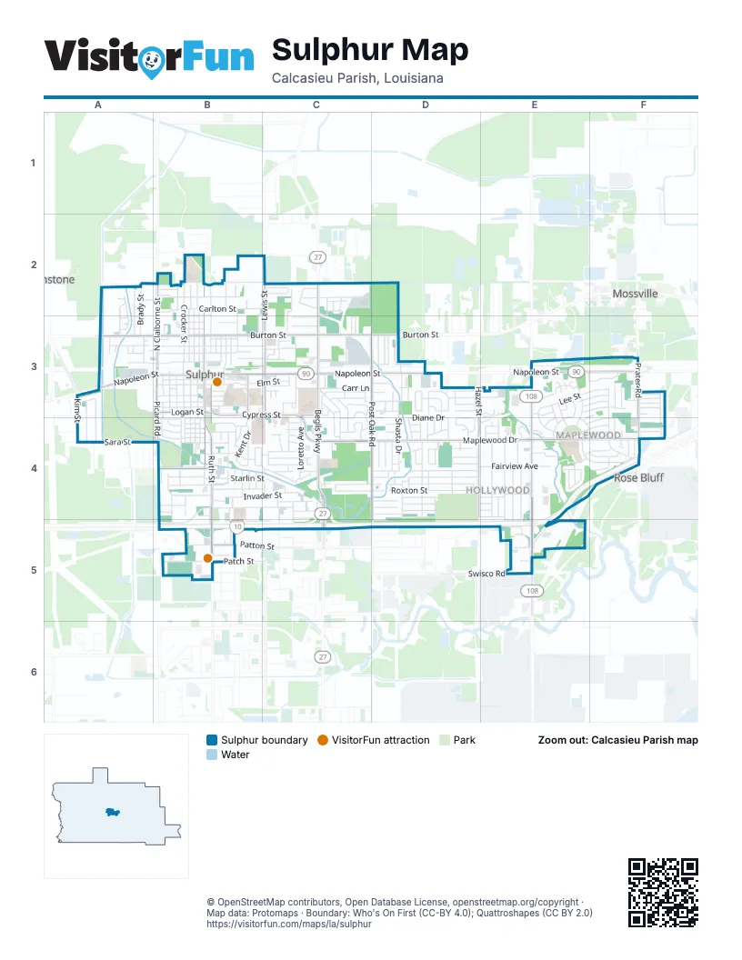
Street index of Sulphur
Each street on the sheet and the grid squares it crosses.
- East Napoleon StreetB3, C3, D3, E3, F3
- South Beglis ParkwayC3, C4, C5
- Ruth StreetB3, B4, B5
- South Cities Service HighwayE4, E5
- Cities Service HighwayE5
- West Napoleon StreetA3, B3
- South Huntington StreetB3, B4
- North Beglis ParkwayC2, C3
- North Cities Service HighwayE3, E4
- Maplewood DriveC4, D4, E4, F4
- Cypress StreetB3, C3, C4
- East Burton StreetB3, C3, D3
- South Post Oak RoadD3, D4, D5
- West Burton StreetA3, B3
- Lewis StreetC2, C3
- North Claiborne StreetB2, B3
- Prater RoadF3, F4
- Sara StreetA4, B4
- South Hazel StreetD4
- Picard RoadB3, B4
- North Huntington StreetB2, B3
- North Hazel StreetD3, D4
- West Parish RoadB4
- Patch StreetB5
- Kim StreetA4
- Logan StreetB3
- Swisco RoadE5
- Patton StreetB5
- Maple StreetC3
- Willow AvenueB3
- North Post Oak RoadD3
- Post Oak RoadD3, D4
- Coach Williams RoadE3
- Beauregard AvenueE4, F4
- North Crocker StreetB2, B3
- Diane DriveD4
- Roxton StreetD4
- East End AvenueF3, F4
- Invader StreetB4, C4
- Henning DriveB4, C4
- Starlin StreetB4, C4
- Madison StreetE4, E5
- Saint Francis StreetD4
- I-10 North Frontage RoadB4, B5
- West Verdine StreetA3, B3
- Vine StreetE4
- Palermo DriveD4
- Carr LaneC3, D3
- South Crocker StreetB3, B4
- South Stanford StreetB3, B4
- Fairview AvenueD4, E4
- Shasta DriveD3, D4
- Mary Ann DriveD4
- Live Oak StreetB2, B3
- Brady StreetA2, A3
- Horseshoe LaneD4
- Saint Joseph StreetD4
- Louisiana AvenueC3, C4
- Pintail StreetD5, E5
- Loretto AvenueC4
- Texas StreetC3
- East Lyons StreetB3, C3
- Laura CircleD3
- Summerwood DriveE3
- Center AvenueE3, E4
- Bryan StreetB3
- Taylor StreetB4, C4
- Broussard RoadC4, C5
- West Brimstone StreetB2
- Quelqueshue StreetE4, E5
- East Carlton StreetB2, C2
- Ann AvenueE3, E4
- Rio Hondo StreetE4, E5
- West Crocker StreetB3, B4
- Louise StreetC3, C4
- North Irwin StreetB2, B3
- North Johnson StreetB2, B3
- Mathew StreetB3, B4
- North Stanford StreetB2, B3
- Mustang StreetB4, C4
- Hoffpauir RoadC2, C3
- Olene DriveC4
- South Irwin StreetB3, B4
- West Cal BoulevardB5
- West Lee StreetE3
- Pearl StreetB3
- West Elizabeth StreetB3
- Mathilda DriveB4
- West Lincoln StreetB3
- West Lyons StreetB3
- Pinecrest DriveC3
- Louis Alleman ParkwayC2
- East Kent DriveB3, B4
- Production DriveD3, E3
- Cass StreetA2, A3
- Michigan AvenueC3, C4
- East Elizabeth StreetB3
- Laura StreetD3, D4
- Pitre StreetB2, B3
- Leland StreetB4
- Landry StreetB4
- Brandi StreetA3, A4
- Melanie DriveC4
- Metric DriveE5
- Elm StreetB3, C3
- East Thomas StreetB3
- Industrial DriveF3
- Darbonne StreetB4
- Tammy DriveD4
- Driftwood DriveE4
- McArthur DriveB3
- West Thomas StreetB3
- Tillman StreetA3, A4
- Phillips StreetB3
- W M Perkins RoadB5
- Mackey StreetB3
- Roberta DriveA2, A3
- Franklin StreetA3
- Navarre StreetB4
- O'Quain DriveB2
- Doiron StreetB3
- Center CircleE4
- Weekly RoadC4
- Sunset StreetB4, B5, C5
- Alabama StreetC3, C4
- Lasalette AvenueC3, C4
- Pecan StreetB4
- North Rose Park AvenueC4, D4
- Linda AvenueC4, D4
- Ash StreetB3
- Petro DriveE5
- Alice StreetC3
- Gulf LaneC4
- Georgia StreetC3
- Woodland StreetA2, A3
- Acadienne StreetD4
- Cherry StreetB3
- Honeysuckle LaneD3
- Beverly PlaceE3, E4
- Cain StreetC3
- West Carlton StreetB2
- Poinsetta RoadF4
- East Lincoln StreetB3
- Augustine DriveD4
- Gabriel DriveD4
- Evangeline StreetD4
- Chiara DriveD3
- Bernadette DriveC4
- Maria DriveC4
- Allen StreetB5
- Dennis AvenueE5
- Beech StreetE3, F3
- Marge LaneC3, C4
- Sherwood DriveC3
- Canal StreetB3
- Division RoadD4
- Quince StreetD4
- East Mimosa DriveD3
- West Mimosa DriveD3
- Morgan RoadD3
- Smith RoadC3
- Hibiscus RoadE4, F4
- East Brimstone StreetB2
- East Lee StreetE3, F3
- Magnolia RoadE4, F4
- Mulberry RoadE4, F4
- Derry DriveF3, F4
- Savoy RoadD3
- Lightning StreetC4
- Lilliput LaneC4
- Self StreetE4
- Vincent LaneD3
- Anthony DriveC2
- Pinewood DriveE3, F3
- Urban StreetB3, C3
- Attakapas StreetE4
- South Kent DriveB4
- Anita StreetD4
- Daigle RoadA4
- Pamela StreetB4
- Edgar StreetB3
- Leora StreetB2
- Evelyn StreetA3
- Marilyn DriveE4
- Stelly LaneC3, C4
- Eucalyptus StreetE3, F3
- Alvin StreetB2
- Boice StreetB4
- Eunice StreetA4
- Poplar StreetD4
- Saunier StreetB4, B5
- Chestnut AvenueD4
- Fasske StreetD3
- Garden StreetE4
- Julie DriveC3
- Peach Tree RoadD3, D4
- Christie DriveC3
- Hildebrandt StreetB3
- Michelle DriveD3
- Roddam StreetB4
- North Lebanon StreetD4
- Ward LaneD4, E4
- South Lebanon StreetD4
- Tamarack StreetB4
- Royal Oak LaneD4
- Cedar LaneD4
- Weil DriveD4, E4
- Arena RoadB5
- Jackson AvenueE3, E4
- Archie RoadC3, D3
- Perry StreetB2
- Bayou Bend DriveE4
- Platt StreetB2
- Lovejoy StreetB4
- Lafargue StreetB4
- Custer StreetB4
- Jacques DriveD3
- Lock StreetB2
- Sherry DriveF3
- Gale StreetD4
- Drost StreetB4
- Bowie StreetB4
- Dubach DriveE3
- Alexa LaneC2
- Adam StreetC2
- Beth StreetD4
- Forest LaneD4
- Pelican StreetD3
- Azalea StreetD3
- Rhua DriveD3
- Ruby LaneD4
- Shannon DriveF3
- Hawthorn DriveF3
- Avenue BB4
- Bonin DriveF4
- Coopershill DriveF3
- Weston DriveF3
- Charles StreetD4
- Bradley StreetB5
- Newcastle DriveE3, E4
- Shady LaneD4
- Cassy DriveF4
- Dean StreetB4
- Lynn LaneE4
- Prince StreetF3
- Cormack StreetC4
- Janice DriveF3
- Jett StreetC4, C5
- Barrett StreetB2, B3
- Keith RoadC3
- West Kent DriveB4
- Still Well StreetB5
- Eveland AvenueF4
- Miller StreetB2
- Park StreetB3
- Perkins StreetB3
- Comanche StreetE4
- Foreman AvenueB4
- Avenue CB4
- Avenue DB4
- James DriveC2
- Angelle DriveD3
- Fuchsia StreetD4
- Augusta StreetB4
- Frederick StreetD3
- Karon StreetD4
- Audalia AvenueE3, E4
- Rose LaneD4
- Colette DriveD3
- South Scott DriveC2
- Audrey StreetB3
- Ginger StreetB4
- Argin StreetC4
- Pepper Creek DriveE4
- Ashley StreetA3
- Rushing RoadC3
- Sheila DriveC3
- South Marauder StreetB4
- Avilia StreetA3
- Teal RoadE5
- Cody StreetB4
- Mill Creek DriveE4
- Harmon RoadF4
- Roxanne StreetD3
- Sycamore StreetB3
- Virginia StreetB3
- Hickok StreetB4
- Jodi DriveF3
- Aracobra StreetB4
- Catherine StreetB4
- Garth DriveC2
- Moss LaneB4, B5
- East Roddam StreetB4
- Southgate StreetB5
- Cherokee StreetE5
- East Verdine StreetB3
- Owens StreetB4
- Sylvan Oak DriveD4
- LeBlanc StreetC4
- Ewel StreetB4
Things to do on the Sulphur map
Places on the map
- 2000 Mount Drive
- Action Tire and Wheel
- Advance Auto Parts
- Aggreko
- All-Star Buick GMC
- All-Star Buick GMC Service
- American Legion Post 179
- Americas Best Value Inn
- ASAP Glass
- Atlas Copco Rental
- Auto Mart
- Autoplex 2000
- AutoZone
- Bass Portable Buildings
- Belts & Blades, Inc.
- Best Western Plus Executive Hotel & Suites
- BigTex Trailers
- Birch Hill Suites
- Blue's Flooring
- Bottom Line Equipment
- Branet, Incorporated
- Bridgestone Hosepower
- Bright Animal Care
- Brookshire Brothers
- Bumper to Bumper Auto Parts
- Cajun Charlie's
- Calcasieu Parish Sheriff's Office Sulphur Law Enforcement Center
- D S Perkins Elementary School
- Direct Tech Drilling
- Frasch Golf Course
- Frasch Park
- LeBlanc Middle School
- Lewis Middle School
- McMurry Park
- North Frasch Softball Complex
- Paper, Print, and Parcel
- Pattison Park
- Sulphur High School
- Superior Supply & Steel
- Team Inc.
Next to Sulphur
- Brimstone
- Mossville
- Rose Bluff
© OpenStreetMap contributors, Open Database License, openstreetmap.org/copyright · Map data: Protomaps · Boundary: Who's On First (CC-BY 4.0); Quattroshapes (CC BY 2.0)















