

Massachusetts map
Boston-Cambridge-Newton Metro Area map
The sheet's index lists 44 highways; I-95, I-495 and MA 128 cross the most grid squares. Things to do inside the boundary: 7 Seas Whale Watch, Adams National Historical Park and American Heritage Museum. Also on it: Acton, Amesbury and Boston.
Open the map (PDF, US Letter)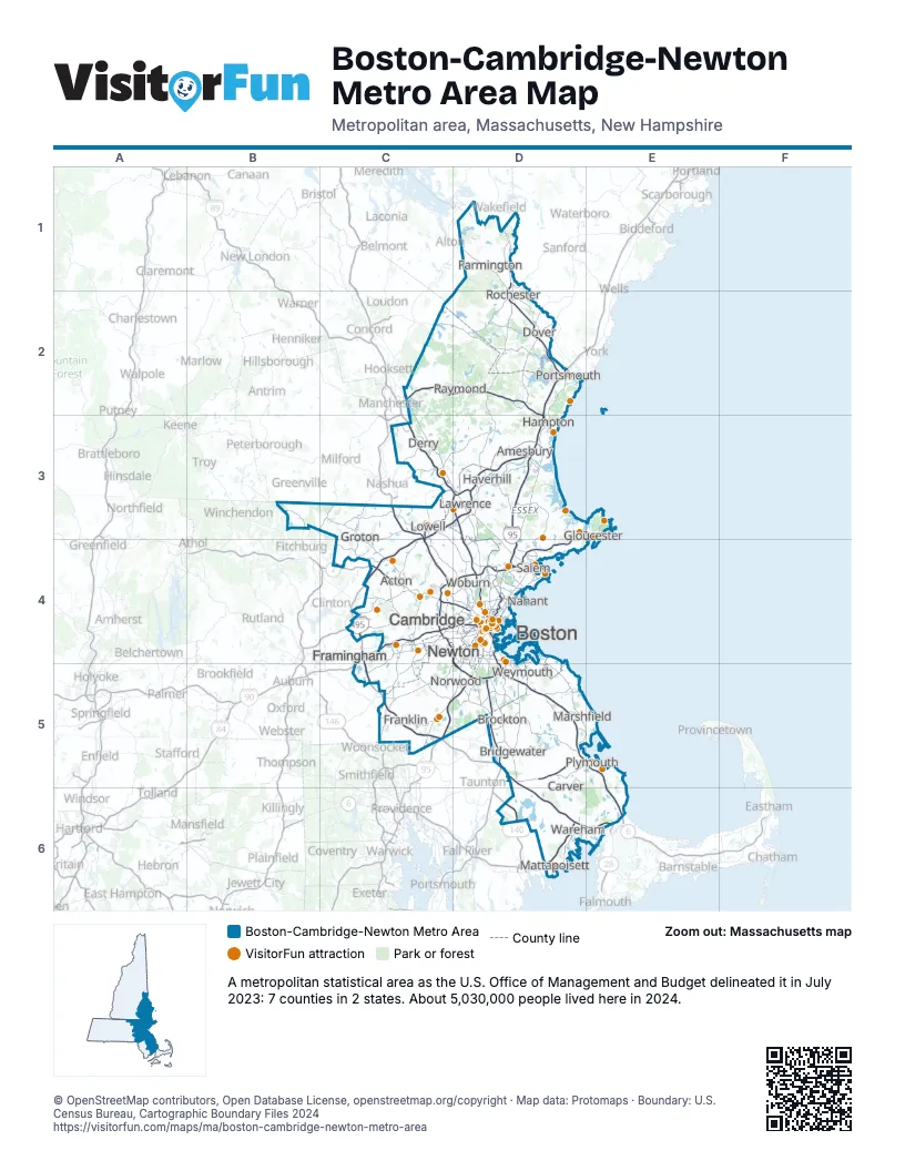
Highway index of Boston-Cambridge-Newton Metro Area
Each highway on the sheet and the grid squares it crosses.
- I-90C4, C5, D4
- I-93C3, D3, D4, D5
- I-95C4, C5, D2, D3, D4, D5
- I-195D6
- I-290C4
- I-495C3, C4, C5, D3, D5, D6
- US 1D2, D4, D5
- US 3C3, C4, D4
- US 4C2, D2
- US 44D5, E5
- US 202C2, D1, D2
- MA 1AD4
- MA 2C4, D4
- MA 2AC4, D4
- MA 3D4, D5, E5, E6
- MA 3AD4
- MA 9C4, D4
- NH 9C2, D2
- NH 11D1
- MA 16D4
- NH 16D1, D2
- MA 24D5
- MA 25D6, E6
- MA 28D4
- MA 30C4
- MA 58D5
- MA 60D4
- MA 62D4
- NH 101C2, D2, D3
- MA 107D4
- NH 107C2, D3
- MA 111C4
- NH 111D3
- MA 114D3, D4
- MA 123D5
- MA 125D3
- NH 125D2, D3
- MA 128C4, D3, D4, D5, E3
- MA 129D4
- MA 133D3
- MA 138D4, D5
- MA 140C5, D6
- MA 203D4
- MA 213D3
Things to do on the Boston-Cambridge-Newton Metro Area map
- 7 Seas Whale Watch
- Adams National Historical Park
- American Heritage Museum
- Arnold Arboretum
- Bass Pro Shops
- Boston Children's Museum
- Boston Common Visitor Center
- Boston Duck Tours
- Boston Public Garden & Swan Boats
- Boston Public Library, Central Library in Copley Square
- Boston Tea Party Ships & Museum
- Bunker Hill Monument
- Buzzards Bay Yacht Charters
- CambridgeSide
- Cape Ann
- Cape Ann Whale Watch
- Captain John Boats
- Charles River Boat Company
- Cheers Beacon Hill
- CityView Trolley Tours
- Crane Beach
- DoubleTree by Hilton Hotel Boston - Downtown
- Embassy Suites by Hilton Boston at Logan Airport
- Faneuil Hall Marketplace & Quincy Market
- Fenway Park Tours
- Franklin Park Zoo
- Ghosts & Gravestones Tour
- Gillette Stadium
- Granary Burying Ground
- Hampton Inn Boston/Peabody
- Harvard Art Museums
- Harvard Museum of Natural History
- Harvard Square
- Harvard Yard
- Hilton Garden Inn Boston-Burlington
- House of the Seven Gables
- Hyatt Place Boston/Braintree
- Hyatt Place Boston/Medford
- Hyatt Place Boston/Seaport District
- Institute of Contemporary Art / Boston (ICA)
- Isabella Stewart Gardner Museum
- La Quinta Inn & Suites by Wyndham Boston Somerville
- La Quinta Inn & Suites by Wyndham Boston-Andover
- Level99
- Lexington Battle Green
- Marblehead Museum
- Massachusetts State House
- MetroWest Boston
- Minute Man National Historical Park
- Museum of Fine Arts, Boston
- Museum of Science
- Myopia Polo Club
- Nashoba Valley Ski Area
- New England Trips
- Newbury Street
- Old North Church & Historic Site
- Old South Meeting House
- Old State House
- Old Town Trolley Tours of Boston
- Paul Revere House
- Peabody Essex Museum
- Plimoth Patuxet Museums
- Plymouth Rock
- Prudential Center
- Real Pirates Salem
- Revolutionary Spaces
- Revolutionary Valley
- Rocky Neck Art Colony
- Salem Maritime National Historical Park
- Salem Trolley
- Salem Witch Museum
- Samuel Adams Boston Brewery
- Shalin Liu Performance Center
- Symphony Hall
- TD Garden
- The Freedom Trail
- The Mother Church
- The Satanic Temple Gallery
- The Sports Museum
- Tour of the Freedom Trail
- Trademark Tours
- Union Oyster House
- USS Constitution & USS Constitution Museum
- View Boston
- Walden Pond
- Witch Dungeon Museum
- Witch Pix
Places on the map
- Acton
- Amesbury
- Boston
- Bridgewater
- Brockton
- Cambridge
- Carver
- Derry
- Dover
- Farmington
- Framingham
- Franklin
- Gloucester
- Groton
- Hampton
- Haverhill
- Lawrence
- Lowell
- Marshfield
- Mattapoisett
- Nahant
- Newton
- Norwood
- Plymouth
- Portsmouth
- Raymond
- Rochester
- Salem
- Wareham
- Weymouth
- Woburn
© OpenStreetMap contributors, Open Database License, openstreetmap.org/copyright · Map data: Protomaps · Boundary: U.S. Census Bureau, Cartographic Boundary Files 2024