

Massachusetts map
Massachusetts map
Things to do inside the boundary: 3 Dukes Fishing, 7 Seas Whale Watch and Adams National Historical Park. Also on it: Appalachian Trail Corridor, Appalachian Trail Corridor - Federal Land and Ashburnham State Forest. Just past the edge: Bridgeport, Concord and New Haven.
Open the map (PDF, US Letter)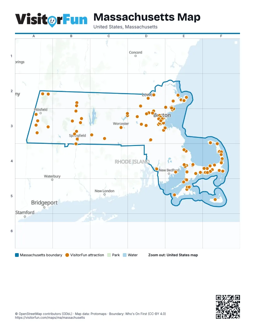
Maps inside Massachusetts
9 maps inside, from the street map of Massachusetts down.
Things to do on the Massachusetts map
- 3 Dukes Fishing
- 7 Seas Whale Watch
- Adams National Historical Park
- American Heritage Museum
- Aquinnah Cliffs
- Arnold Arboretum
- Arnold's Lobster & Clam Bar
- Art's Dune Tours
- Bass Pro Shops
- Bass River Kayaks and Paddle Boards
- Battleship Cove
- Black Dog Tall Ships
- Bookstore & Restaurant
- Boston
- Boston Children's Museum
- Boston Common Visitor Center
- Boston Duck Tours
- Boston Harbor Islands National & State Park
- Boston Public Garden & Swan Boats
- Boston Public Library, Central Library in Copley Square
- Boston Tea Party Ships & Museum
- Bunker Hill Monument
- Buzzards Bay Yacht Charters
- Cahoon Museum of American Art
- CambridgeSide
- Canna Provisions
- Cape Ann
- Cape Ann Whale Watch
- Cape Cod
- Cape Cod Canal Region
- Cape Cod Central Railroad
- Cape Cod Lobster Cruises
- Cape Cod Melody Tent
- Cape Cod Museum of Art
- Cape Cod Museum of Natural History
- Cape Cod National Seashore
- Cape Cod Rail Trail
- Cape Escape Adventure Golf
- Captain John Boats
- Cataumet Crossing
- Cee Jay Fishing
- Center for Coastal Studies
- Central Massachusetts
- Charles River Boat Company
- Chatham Lighthouse & Main Street
- Chatham Sport Fishing
- Cheers Beacon Hill
- Christmas Joy of Cape Cod
- CityView Trolley Tours
- Coast Guard Heritage Museum
- College Light Opera Company
- Commercial Street, Provincetown
- Crane Beach
- Dolphin Fleet Whale Watch
- DoubleTree by Hilton Hotel Boston - Downtown
- Edward Gorey House
- Embassy Suites by Hilton Boston at Logan Airport
- Emily Dickinson Museum
- Faneuil Hall Marketplace & Quincy Market
- Fenway Park Tours
- Fine Arts Work Center
- Franklin County Visitors Information Center
- Franklin Park Zoo
- Ghosts & Gravestones Tour
- Gillette Stadium
- Gloucester
- Granary Burying Ground
- Hampton Inn Boston/Peabody
- Hancock Shaker Village
- Harvard Art Museums
- Harvard Museum of Natural History
- Harvard Square
- Harvard Yard
- Helen H Deep Sea Fishing
- Heritage Museums & Gardens
- Highland Light
- Hilton Garden Inn Boston-Burlington
- Historic Deerfield
- Holyoke Mall
- House of the Seven Gables
- Hy-Line Cruises
- Hyannis Main Street
- Hyannis Whale Watcher Cruises
- Hyatt Place Boston/Braintree
- Hyatt Place Boston/Medford
- Hyatt Place Boston/Seaport District
- Icon Museum and Study Center
- Institute of Contemporary Art / Boston (ICA)
- Isabella Stewart Gardner Museum
- Island Alpaca
- Island Queen
- Jack's Boat Rental
- Jacob's Pillow
- John F. Kennedy Hyannis Museum
- John F. Kennedy Presidential Library and Museum
- Johnny Appleseed Trail
- La Quinta Inn & Suites by Wyndham Boston Somerville
- La Quinta Inn & Suites by Wyndham Boston-Andover
- Level99
- Lexington Battle Green
- Liberty Fleet of Tall Ships
- Lizzie Borden House
- Marblehead
- Marblehead Museum
- Martha's Vineyard
- Martha's Vineyard Tours and Transport
- MASS MoCA
- Massachusetts State House
- MetroWest Boston
- Minute Man National Historical Park
- Museum of Fine Arts, Boston
- Museum of Science
- Myopia Polo Club
- Naismith Basketball Hall of Fame
- Nantucket Whaling Museum
- Nashoba Valley Ski Area
- New England Aquarium
- New England Trips
- Newbury Street
- Norman Rockwell Museum
- Old North Church & Historic Site
- Old South Meeting House
- Old State House
- Old Sturbridge Village
- Old Town Trolley Tours of Boston
- Onset
- Orleans Firebirds
- Patriot Party Boats
- Paul Revere House
- Peabody Essex Museum
- Pilgrim Monument & Provincetown Museum
- Pirate's Cove Adventure Golf
- Plimoth Patuxet Museums
- Plymouth Rock
- Predatuna Sportfishing
- Provincetown Art Association and Museum (PAAM)
- Provincetown Chamber of Commerce
- Prudential Center
- Quincy
- Real Pirates Salem
- Revolutionary Spaces
- Revolutionary Valley
- Rocky Neck Art Colony
- Salem
- Salem Maritime National Historical Park
- Salem Trolley
- Salem Witch Museum
- Samuel Adams Boston Brewery
- Sandwich
- Sandwich Glass Museum
- Schooner Liberté
- Shalin Liu Performance Center
- Shark Shark Tuna Fishing Charters
- Sheraton Springfield Monarch Place Hotel
- Six Flags New England
- Ski Butternut
- Steamship Authority
- Symphony Hall
- Tanglewood
- TD Garden
- The Cape Playhouse
- The Clark Art Institute
- The Eric Carle Museum of Picture Book Art
- The Freedom Trail
- The Lobster Pot
- The Mother Church
- The Satanic Temple Gallery
- The Sports Museum
- The Wellfleet Beachcomber
- Tour of the Freedom Trail
- Trademark Tours
- Trainmaster's Inn
- Union Oyster House
- USS Constitution & USS Constitution Museum
- View Boston
- Walden Pond
- Wellfleet Drive-In Theatre
- Whydah Pirate Museum
- Witch Dungeon Museum
- Witch Pix
- Yankee Candle Village
Places on the map
- Appalachian Trail Corridor
- Appalachian Trail Corridor - Federal Land
- Ashburnham State Forest
- Beartown State Forest
- Birch Hill Reservoir Area
- Blue Hills Reservation
- Cape Cod National Seashore
- Cape Cod Rail Trail
- Cochituate Aqueduct Trail
- Connecticut River Greenway State Park
- Douglas State Forest
- Farmington River Watershed
- Fort Devens Range Complex
- Great Meadows National Wildlife Refuge
- Harold Parker State Forest
- Joint Base Cape Cod
- Leominster State Forest
- Middlefield State Forest
- Mohawk Trail State Forest
- Mount Holyoke Range State Park
- Mount Washington State Forest
- Myles Standish State Forest
- Neponset River Reservation
- Norcross Wildlife Sanctuary
- Northfield State Forest
- October Mountain State Forest
- Otis State Forest
- Peru Wildlife Management Area
- Pittsfield State Forest
- Sandisfield State Forest
- Savoy Mountain State Forest
- Sudbury Reservoir Watershed
- Taunton Wild and Scenic River
- Tolland State Forest
- Wachusett Reservoir Watershed
- Warwick State Forest
- Wendell State Forest
- Westminster State Forest
Next to Massachusetts
- Bridgeport
- Concord
- New Haven
- New London
- Stamford
- Waterbury
© OpenStreetMap contributors (ODbL) · Map data: Protomaps · Boundary: Who's On First (CC-BY 4.0)