

Massachusetts map
East Longmeadow map
About 16,515 people live here (Census Bureau, 2024 estimate). The sheet's index lists 300 streets; Somers Road, Parker Street and Pease Road cross the most grid squares. Also on it: Campbell Conservation Area-2, East Longmeadow High School and Elmcrest Country Club.
Open the map (PDF, US Letter)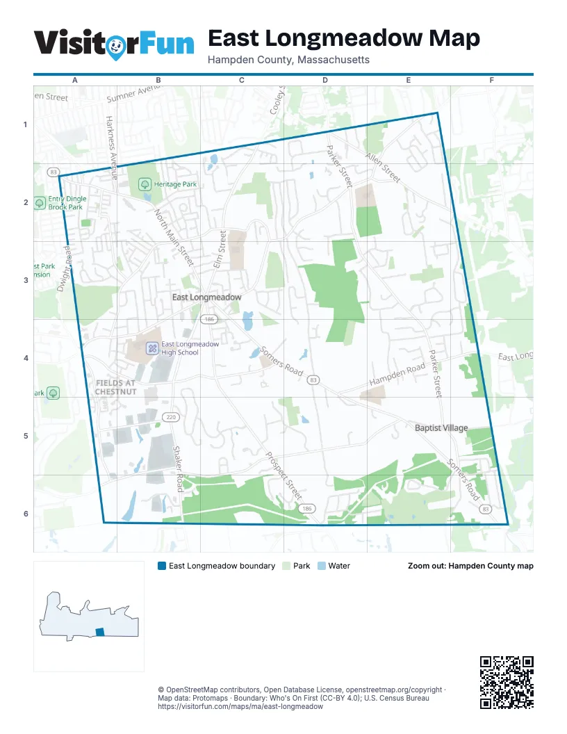
Street index of East Longmeadow
Each street on the sheet and the grid squares it crosses.
- Somers RoadC3, C4, D4, D5, E5, F5, F6
- North Main StreetA2, B2, B3, C3
- Pleasant StreetC2, C3
- Center SquareC3
- White StreetA2
- Parker StreetD1, D2, D3, E3, E4, E5
- Shaker RoadB3, C3, B4, B5, B6
- Prospect StreetC3, C4, C5, D6
- Chestnut StreetA4, B4, C4
- Elm StreetC1, C2, C3
- Allen StreetD1, E1, E2
- Hampden RoadD4, E4, F4
- Maple StreetB3, C3, A4, B4
- Meadow Brook RoadE5, F5
- Harkness AvenueA2, B2
- Dwight RoadA4
- Hall Hill RoadD6
- Pease RoadB5, C5, D5, E5, B6, C6
- Porter RoadE1, C2, D2, E2
- Benton DriveA4, A5, A6
- Westwood AvenueB3, A4
- Mapleshade AvenueB2, C2, B3
- Denslow RoadB5, A6, B6
- Vineland AvenueA2, A3, B3
- Industrial DriveA5, B5
- Markham RoadE2
- Lombard AvenueA2
- Dorset StreetA2
- Kensington AvenueA2
- Audubon StreetA2
- Kibbe RoadD2, D3, D4
- Millbrook DriveF2, F3
- Canterbury CircleB4, B5
- Pinehurst DriveF5, E6, F6
- Tanglewood DriveE2, E3
- Brookhaven DriveE1, E2
- Nottingham DriveE3
- Pembroke TerraceB5, C5
- Stonehill RoadE3, E4
- Fernwood DriveD3, E3
- Lee StreetD4, D5
- Orchard RoadD1, C2, D2
- Braeburn RoadA2, A3
- Old Farm RoadC5, D5
- Sanford StreetF3, E4, F4
- Glynn Farms DriveD3, D4
- South Brook RoadD6
- Franconia CircleA3
- Country Club DriveD6, E6
- Dearborn StreetB2, C2
- Melwood AvenueB3, B4
- Meadow RoadC2
- Evergreen DriveE1
- Rogers RoadB3, B4
- Somersville RoadF5, E6, F6
- Colony DriveC2, D2
- Hanward HillC3
- Day AvenueB2, C2
- Ridge RoadD2
- Deer Park DriveB6
- Mill RoadE5, F5
- East Circle DriveD2
- Bayne StreetB3, B4
- Fields DriveB4, B5
- Windham DriveE3, F3, E4
- Smith AvenueB2, B3
- Mountainview RoadD2, D3
- Gates AvenueB1, B2
- Hillside DriveC2, C3, D3
- Favorite LaneD5, D6
- Lasalle StreetB2
- Pineywoods DriveF5
- Indian Spring RoadC3
- Pine Grove CircleD1
- Bella Vista DriveC6, D6
- Brynmawr DriveF5, F6
- Glen Heather LaneF5, F6
- Meadowbrook RoadE5
- Timber DriveE4
- Redin DriveC5, C6
- Edmund StreetB3
- Oak Brook DriveC1
- Lenox CircleE2
- Rural LaneD2
- Scantic DriveF5, F6
- Harwich RoadB2, C2
- Holland DriveE2
- Greenwich RoadD2, E2
- Devonshire TerraceC5
- Helen CircleB2
- Marshall StreetA4, B4
- Forest Hill RoadD1
- Marci AvenueD3, E3
- Prospect Hills DriveC5
- Gerrard AvenueA2
- Bent Tree DriveE4
- Fairview StreetB2
- Dartmouth LaneC5
- Birch AvenueA2, B2
- Wood AvenueA2
- Sutton PlaceE1
- Thompkins AvenueB1, B2
- Pioneer CircleE3
- Pilgrim RoadD2
- Baymor DriveB3
- Redstone DriveC2
- Avery StreetA3
- Westernview CircleC4
- Taylor StreetC3
- John StreetB2
- Hidden Ponds DriveC1, C2
- Woodbridge DriveE2
- Waterman AvenueB2, B3
- Capri DriveC6, D6
- High Pine CircleE3
- Rockingham CircleC5
- Thompson StreetA2
- Senecal PlaceD2
- Rankin AvenueC3
- Savoy AvenueB3, B4
- Longview DriveE3, F3
- Holy Cross CircleA2
- Speight ArdenB3, C3
- Heatherstone DriveC3
- Spruce StreetB4, C4
- Peachtree RoadE3
- Broadleaf CircleA4, B4
- Deer Run TerraceE5
- Maplehurst AvenueB3
- Cooley AvenueA3
- Donamor LaneB3
- North Circle DriveC2, D2
- Deerfoot DriveE1, E2
- Van Dyke RoadA2
- Patterson AvenueA2, A3
- Saint Joseph DriveC4, D4
- Breezy Knoll RoadC2, C3
- Kenneth Lunden DriveE4
- Shawmut StreetB1, B2
- Quarry Hill RoadC4
- Glendale RoadB3
- Highlandview AvenueB2, B3
- South Bend LaneD4, D5
- Village Green CircleB2
- Birchland AvenueC3
- Knollwood DriveB3, B4
- Brier LaneC3, F5
- James StreetA3, B3
- Terry LaneE4
- Greenacre LaneB3, C3
- Wilder LaneC3
- Forbes Hill RoadF6
- Nelson StreetA2
- Windsor LaneB5, C5
- Mayfair StreetB2
- Lynwood RoadC1
- Ainslie DriveF6
- Westminster StreetB2
- Autumn RidgeC5
- Somerset StreetB2
- Baldwin StreetB3
- Callender AvenueC3
- East Village RoadD2
- High StreetC3, C4
- Maryland StreetB2
- Michel StreetD4, D5
- Anna Marie LaneE4
- Powder Hill RoadB3
- Sturbridge LaneD4
- Merriam StreetC2, C3
- Alandale DriveA4, B4
- Schuyler DriveA4, A5
- Lori LaneA4, B4
- Shaw StreetB2
- Quarry Hill Road ExtensionC4
- Dawes StreetC1, C2
- Brook StreetB3, C3
- Rollins DriveE3
- Fairhaven DriveA4
- Hazelhurst AvenueA2
- Maple CourtB3, B4
- North StreetB2
- Clareside DriveE4
- Cedar Hill RoadB3
- Clover LaneA5, B5
- Moore StreetB2, B3
- Euclid AvenueA2
- Mayflower LaneD2, D3
- Tracey LaneC4
- Judy LaneC1
- Cross Meadow RoadE3
- Frankwyn StreetB3, C3
- Heritage CircleD2
- Yorkshire PlaceB5
- Vadnais StreetB2
- School StreetC3, C4
- Benjamin StreetA2
- Bluegrass DriveA4, A5
- Albano DriveC1, C2
- Scarlett DriveE3
- Norden StreetA4, B4
- White AvenueC3
- Crescent HillC4
- Sylvester StreetE4
- Fairway LaneA4
- Anne StreetB2
- Fox Hedge RoadE1
- Maynard StreetC2
- Overbrook RoadD3
- West Allen Ridge RoadB2
- South Meadow RoadD5
- Meadowlark DriveD6
- Old Pasture DriveC5
- Pondview DriveD1, D2
- Robin StreetB2, A3, B3
- Fisher AvenueB2, B3
- Crestview RoadD6
- Halon TerraceB6
- Donald AvenueA2, A3
- Abbey LaneC5
- Spring Valley RoadC3
- Wellington DriveF3, E4, F4
- Fenway LaneD1
- Wedgewood RoadD1
- Mereline AvenueA2
- Crane AvenueB3
- Worthy AvenueA3
- Linden AvenueB3
- Voyer AvenueB3
- Boulder StreetA3
- Ericka CircleD2
- Inward CommonsC4
- Saugus AvenueB3
- Alpine AvenueB3
- Kingman AvenueA2, A3
- Burt AvenueA4, B4
- Fraser DriveE4
- Admiral StreetA2
- Newbury AvenueB3
- Tamarack DriveE1
- Park PlaceC3
- Angela LaneF4
- Virginia LaneC2
- Garland AvenueA2, A3
- Overlook DriveE4
- Lindendale AvenueB3
- Orpheum AvenueA2
- Ribbon Grass LaneA5, B5
- Rolling Meadow LaneE4
- Barnum StreetA2
- Grove AvenueB3
- Ruffino RoadD6
- Chadwyck LaneE1
- Elmcrest StreetC3
- Auburn StreetB2
- Amy LaneE2, E3
- Black Dog LaneD3
- Oak Bluff CircleC2
- Betterley LaneC4
- Melody LaneC2
- Woodlawn StreetC4
- Roderick AvenueA2
- Winterberry LaneE1
- Melvin AvenueA2
- Fern Glen RoadD3, E3
- Lester StreetB2, B3
- Granby StreetA2
- Millbrook CircleE2, F2
- Anthony DriveA2, B2
- Oakwood CircleC2
- Bettswood RoadE5
- Athens StreetA2
- Oxford LaneE4
- Young AvenueA2
- Hunting RoadF2
- Pecousic DriveA3
- Skyline DriveE2
- Apple Blossom LaneD1, D2
- Edwill RoadE4
- Summerfield StreetA2
- High Meadow CircleC5, D5
- Dewey AvenueB3
- Acorn StreetA2, B2
- Juniper LaneE1
- Sherwood LaneE3
- Silver Fox LaneE4
- Elizabeth StreetB2
- Fifth StreetB3
- Ridgewood RoadD6
- Leo AvenueC3
- Lessard CircleA4
- Chestnut Street PlaceC4
- Susan StreetB4
- Bond AvenueB4
- Barrie RoadA4, B4
- Pine StreetA2
- Rosemont StreetA2
- Feather Reed LaneB4
- Purves StreetB2
- Tufts StreetA2
Places on the map
- All-Purpose East Longmeadow
- Calkins Ave. Cons. Area
- Campbell Conservation Area-1
- Campbell Conservation Area-2
- Campbell Conservation Area-3
- Center Field
- Charles Buckingham Cons. Area
- Craven Conservation Area
- East Longmeadow High School
- East Longmeadow Public Library
- East Longmeadow Public Schools
- East Longmeadow Town Hall
- Elmcrest Country Club
- Fenway Driving Range
- Fenway Golf
- Franconia Golf Course
- Hampden Rd. Conservation Area
- Heritage Park
- High Pine Conservation Area
- Hoover Quarry Conserv. Area
- Indian Spring Cons. Area
- Jarvis Nature Sanctuary
- Jawbuck Brook Reservoir
- Kenmore Conservation Area
- McCarthy Hill
- Meadow Brook School
- Meadowbrook Farm
- Meadowbrook Farms
- Mill Road Conservation Area
- Montessori Children's Cor
- Mountain View School
- Peachtree Rd. Conserv. Area
- Pine Knoll Golf Course
- Pine Knoll Recreation Area
- Pine Quarry Conservation Area
- Pleasantview Senior Center
- Tanglewood Conservation Area
- The UPS Store
- Veratti Conservation Area
- Watchaug Meadows Conserv. Area
© OpenStreetMap contributors, Open Database License, openstreetmap.org/copyright · Map data: Protomaps · Boundary: Who's On First (CC-BY 4.0); U.S. Census Bureau















