

Massachusetts map
Gloucester map
About 30,491 people live here (Census Bureau, 2024 estimate). The sheet's index lists 300 streets; Yankee Division Highway, Washington Street and Western Avenue cross the most grid squares. Things to do inside the boundary: Cape Ann, Cape Ann Whale Watch and Rocky Neck Art Colony.
Open the map (PDF, US Letter)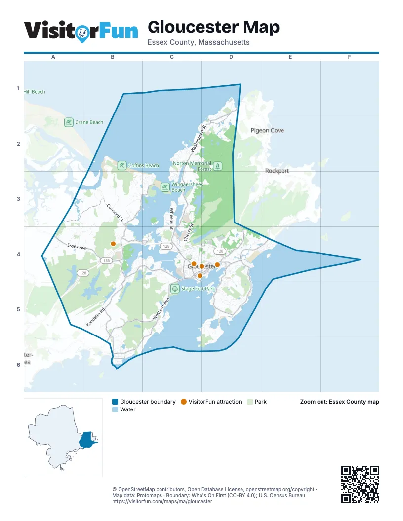
Street index of Gloucester
Each street on the sheet and the grid squares it crosses.
- Yankee Division HighwayA4, B4, C4, D4, A5
- Washington StreetD1, C2, D2, C3, C4
- Western AvenueC4, B5, C5, B6
- Eastern AvenueD3, D4
- Main StreetD3, C4, D4
- Rogers StreetC4, D4
- Middle StreetC4, D4
- Blackburn CircleD4
- Commercial StreetC4, C5
- Grant CircleC4
- Angle StreetC4
- Essex AvenueA4, B4, C4
- Concord StreetA3, B3, B4
- Atlantic RoadD4, D5
- Thatcher RoadD4, E4
- East Main StreetD4, D5
- Bass AvenueD4
- Langsford StreetD1, D2
- Farrington AvenueD5
- Eastern Point RoadD5
- Andrews StreetD2
- Sayward StreetD4
- Magnolia AvenueB4, C4, B5, B6
- Hesperus AvenueC5, B6, C6
- Atlantic StreetB3, C3
- Prospect StreetC4, D4
- Causeway StreetB4
- Centennial AvenueC4
- Crafts RoadC4
- Norman AvenueB6
- Rust Island RoadB4, C4
- Raymond StreetB6
- Flannagan SquareD4
- Goose Cove RoadC3, D3
- Bray StreetB3, A4, B4
- Eastern Point BoulevardC5, D5, C6, D6
- Cherry StreetC3, C4
- High StreetD2
- Wheeler StreetC3, C4
- Wingaersheek RoadB2, B3
- Coles Island RoadB3
- Norwood HeightsC2
- Fernald StreetB4
- Leonard StreetC2, C3
- Sumner StreetA3, A4
- Revere StreetC2, D2
- Kondelin RoadB5
- Castle View DriveB3
- Dennison StreetC3, D3
- Grapevine RoadD5
- Mount Pleasant AvenueD4, D5
- Maplewood AvenueC4
- Gloucester AvenueC4
- Laurel StreetB4, B5
- Holly StreetC3
- Riverview RoadC4
- High Popples RoadD5
- Bond StreetC4, C5
- Witham StreetD4
- Woodward AvenueB4
- Shore RoadB6
- Great Republic DriveD4
- Jebeka LaneB3
- Quarry StreetC2, D2
- Kennedy RoadB5, B6
- Dory RoadD4
- Adams Hill RoadC2, C3
- Atlantic AvenueB3, C3
- Massachusetts AvenueB3
- Woodman StreetA4
- Old Nugent Farm RoadD4
- Doctor Osman Babson RoadC4
- Niles Pond RoadD5
- School House RoadD4
- Thurston Point RoadC3
- Ledge RoadD5
- Beach RoadD4
- Rowley ShoreC2, D2
- Salt Island RoadD4, E4
- Fort Hill AvenueD5, D6
- Dolliver Neck DriveC5
- Hough AvenueC5
- Gee AvenueC3
- Way RoadD4, D5
- Salt Marsh LaneB3
- Plover WayB3
- Rocky Neck AvenueD5
- Stanwood AvenueB4
- Grove StreetC4
- Ye Olde County RoadB4, C4
- Poplar StreetC4
- New Way LaneB4
- Bennett Street NorthC2, C3
- Lincoln StreetA4
- Moorland RoadD4
- Old Salem RoadB5, C5
- Starknaught HeightsD4, E4
- Reynard StreetC3, C4
- Englewood RoadB6
- Nashua AvenueC2
- Pleasant StreetC4, D4
- Two Penny LaneB2, B3
- Cart Track DriveC2
- Perkins StreetD4
- Vine StreetC3
- Woodbury StreetD1, D2
- Harrison AvenueD4
- Walker StreetA4
- Rockholm RoadC2
- Sea Fox LaneB3
- Wolf Hill LaneC4
- Friend StreetD4
- Leverett StreetD2
- Veterans WayC4
- Decatur StreetD4
- Cliff RoadD4, E4
- Haskell StreetD4
- Harriet RoadD5
- Warner StreetC4, D4
- River RoadC3
- Bungalow RoadB3, C3
- Lawndale CircleB5
- Reservoir RoadC4
- Norrock RoadC2
- Souther RoadD4
- Becker CircleB4
- Folly Point RoadD1
- Totten LaneB3
- Old County RoadD4
- Presson Point RoadB4
- Lawrence Mountain RoadB4
- Hodgkins StreetC3, C4
- Brierwood StreetC2
- King Philip RoadC4
- Links RoadD5
- Kent RoadB4
- Lexington AvenueB6
- Heights At Cape AnnC4
- Nautilus RoadD4
- Lake RoadB6
- Waterman RoadC3
- Mount Vernon StreetD4
- Birch Grove HeightsC4
- Fuller StreetB6
- Bass Rocks RoadD4
- Keystone RoadA4
- Marble RoadD5
- Ferry StreetC4
- Rockport RoadE4
- Hutchins CourtC2, D2
- Ocean HighlandsB6
- Brightside AvenueD4
- Pond RoadD4
- Flume RoadB6
- Oakes AvenueB6
- Westbrook LaneB5
- Bennett Street SouthC3
- Saint Anthonys LaneD5
- Saint Daniel AvenueD4
- Wolf Hill RoadC4
- Dorset DriveC2
- Overlook AvenueB4
- Walnut StreetC2, C3
- Colburn StreetC2, D2
- Honeysuckle RoadC3
- Valley RoadB3
- Fernwood Lake AvenueB4, C4
- Ocean AvenueB6
- Squam Rock RoadC2, C3
- Blynman AvenueC4
- Taylor StreetD4
- Lyndale AvenueB4
- Schooner RidgeB3
- Marina DriveD4
- Andrews CourtA4
- Railroad AvenueC4
- Saint Louis AvenueD5
- Winthrop AvenueB4, C4
- Mussel Point RoadC5
- Uncas RoadC4
- Commonwealth AvenueC4
- Beacon StreetC4
- Biskie Head PointC4
- Granite StreetC4
- Hartz StreetD4
- Coggeshall RoadD1
- Whites Mountain RoadB4
- Blackburn DriveD4
- Marble StreetD5
- Chapel StreetD4, D5
- Brace CoveD5
- Madison AvenueC4
- Riverside AvenueC4
- Whittemore StreetC4
- Goodwin RoadC3, D4
- Samoset RoadB4, C4
- Paws LaneB4
- Long Hill RoadB5, B6
- Ramparts Field RoadD5, D6
- Stillington DriveC5
- Brooks RoadB3
- Edgemoor RoadD5
- Orchard RoadD5
- Corliss AvenueC4
- Fort SquareC4, C5
- Marsh StreetC4
- School StreetC4
- Trask StreetD4
- Summer StreetC4
- Macomber RoadC3
- Apple StreetC3
- Mansfield StreetC4
- Elmo LaneC3
- Harbor LoopD4
- Hickory StreetD2
- State Fish PierD4
- Beachcroft RoadD4
- Burnham StreetC4, D4
- Hesperus CircleB6
- Ferry Hill RoadC4
- Webster StreetD4
- Homestead DriveC2
- Whistle Stop WayC4
- Edgewood RoadC4
- Gurdons LaneD2
- Prentiss RoadD5
- Wesley StreetC3
- Cobblestone LaneC4
- Beechbrook RoadB4
- Ryan RoadB5
- Rouse RoadD6
- Perrywinkle LaneC4
- Dogtown RoadC3
- Long WharfB3, C3
- Toronto AvenueD5
- Cleveland StreetC4
- Linden RoadC4
- Dodge StreetD4
- Millett StreetC4, D4
- Estuary WayB4
- Rockwood LaneD1
- Forest LaneA4
- Linden AvenueC4, B6
- Shore Hill RoadC3
- Willow StreetC4
- Gloucester CrossingD4
- Rocky Pasture RoadD4
- Story RoadB5
- Heath HeightsB4, C4
- Sleepy Hollow RoadB3, C3
- Starknaught RoadD4, E4
- Wolf Hill WayC4
- Horton StreetD5
- Derby StreetC4
- Whipple Woods RoadA4
- Barker AvenueD2
- Green StreetD4
- Silva CourtD4
- Exchange StreetC4
- Patriots CircleC4
- Traverse StreetD4
- Larose AvenueB4
- Oxford RoadD4, E4
- Clearview AvenueB4
- Wonson StreetD5
- Whale Rocks RoadB3
- Highland StreetD4, D5
- Page StreetD4
- Lowe DriveB6
- Magnolia Woods Soccer Fields RoadB5
- Barn LaneD4
- Mussel Point WayC5
- Sargent StreetC4
- Pew AvenueB4
- Blackburn CenterD4
- Hillside RoadD5
- Riggs Point RoadC3
- North Kilby StreetC2
- Emerson AvenueC4
- G AvenueD1
- Lands End LaneD5
- Nautical HeightsD5
- Castle Hill RoadC5
- Parker StreetD4
- Beeman School Access RoadC3
- Lookout StreetC4
- Ames DriveC2
- Elm StreetD4
- Calder StreetD4, D5
- Glenmere AvenueC4
- Malcolm RoadC4
- Norseman AvenueD1, D2
- Drumhack RoadD6
- Myrtle SquareC4
- Cononicus RoadC4
- Lincoln ParkC4
- Dune LaneC3
- Chestnut StreetD4
- Ocean View DriveD5
- Skipper WayB3, C3
Things to do on the Gloucester map
Places on the map
- Addison Gilbert Hospital
- Annisquam Woods
- Babson Reservoir
- Babson Watershed
- Bass Rocks Golf Club
- Beaver Swamp
- Beeman Memorial School
- Bond Hill Reservoir Water Supply Land
- Camp Spindrift
- Cape Ann
- Cape Ann Campsite
- Cape Ann Sportsmans Club
- Coffins Beach
- Dogtown Conservation Land
- Dogtown Woods
- Dolliver Beach Neck Marshes
- Dykes Pond
- Fernwood Lake
- Fernwood Lake Water Supply Land
- Gloucester High School
- Gloucester Water Supply Land
- Goose Cove Reservation
- Goose Cove Reservoir Watershed
- Goose Cove Resevoir
- Haskell Pond
- Lily Pond
- Marble Road Conservation Area
- Mount Ann Park
- Normans Woe Wildlife Sanctuary
- Norton Memorial Forest
- Plum Cove Recreation Area
- Ravenswood Park
- Stage Fort Park
- Tompson Street Reservation
- Wallace Pond
- Wallace Pond Water Supply Land
- Water Supply Land
- Whitemore Salt Marsh
- Wingaersheek Beach
- Wingaersheek Uplands
Next to Gloucester
- Pigeon Cove
- Rockport
© OpenStreetMap contributors, Open Database License, openstreetmap.org/copyright · Map data: Protomaps · Boundary: Who's On First (CC-BY 4.0); U.S. Census Bureau















