

Massachusetts map
Essex County map
About 823,938 people live here (Census Bureau, 2024 estimate). The sheet's index lists 3 streets; Yankee Division Highway, Loop Connector and enter I495 cross the most grid squares. Things to do inside the boundary: 7 Seas Whale Watch, Cape Ann and Cape Ann Whale Watch.
Open the map (PDF, US Letter)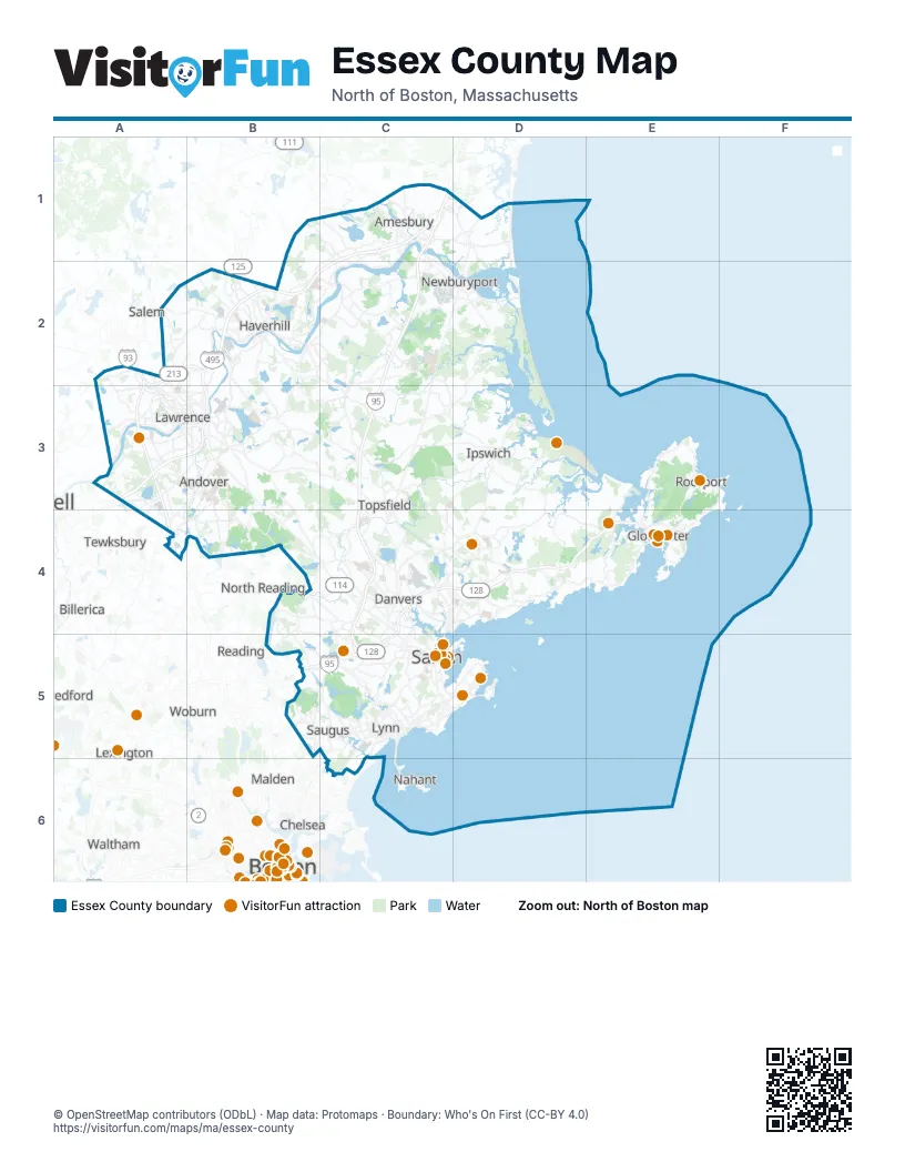
Street index of Essex County
Each street on the sheet and the grid squares it crosses.
- Loop ConnectorA2, B2, A3
- enter I495B2
- Yankee Division HighwayC4, D4, E4, B5, C5
Things to do on the Essex County map
- 7 Seas Whale Watch
- Cape Ann
- Cape Ann Whale Watch
- Crane Beach
- Gloucester
- Hampton Inn Boston/Peabody
- House of the Seven Gables
- La Quinta Inn & Suites by Wyndham Boston-Andover
- Marblehead
- Marblehead Museum
- Myopia Polo Club
- Peabody Essex Museum
- Real Pirates Salem
- Rocky Neck Art Colony
- Salem
- Salem Maritime National Historical Park
- Salem Trolley
- Salem Witch Museum
- Shalin Liu Performance Center
- The Satanic Temple Gallery
- Witch Dungeon Museum
- Witch Pix
Places on the map
- 100 Acre Marsh
- Aggregate Industries
- Albert Retelle Reservation
- Alexander Salt Marsh
- Alt Reservation
- Amesbury
- Amesbury Town Forest
- Andover
- Andover Country Club
- Annisquam Woods
- Appleton Farms
- Appleton Farms Grass Rides
- Artichoke River
- Artichoke River Reservoir
- Artichoke Woods
- Ash Swamp
- Ash Swamp (Great Swamp)
- Babson Reservoir
- Babson Watershed
- Back Bay
- Baker's Meadow Reservation
- Baldpate Hill
- Baldpate Pond
- Baldpate Pond State Park
- Ball Flats
- Barett Reservation
- Barker Farm
- Bass Rocks Golf Club
- Beaver Dam Brook Reservation
- Beaver Pond Area
- Belleville
- Bellevue Reservation
- Beverly
- Beverly Commons
- Beverly Golf & Tennis Club
- Birch Pond
- Black Swan Country Club
- Bow Ridge Conservation Area
- Boxford
- Boxford State Forest
Next to Essex County
- Bedford
- Billerica
- Boston map
- Cambridge
- Chelsea
- Lexington
- Malden
- Medford
- Melrose
- North Reading
- Reading
- Revere
- Salem
- Seabrook
- Tewksbury
- Waltham
- Watertown
- Wilmington
- Winchester
- Woburn
© OpenStreetMap contributors (ODbL) · Map data: Protomaps · Boundary: Who's On First (CC-BY 4.0)