

Massachusetts map
Lowell map
About 120,418 people live here (Census Bureau, 2024 estimate). The sheet's index lists 300 streets; Veterans of Foreign Wars Highway, Varnum Avenue and Middlesex Street cross the most grid squares. Things to do inside the boundary: Clemente Park, Lowell Memorial Auditorium and New England Quilt Museum.
Open the map (PDF, US Letter)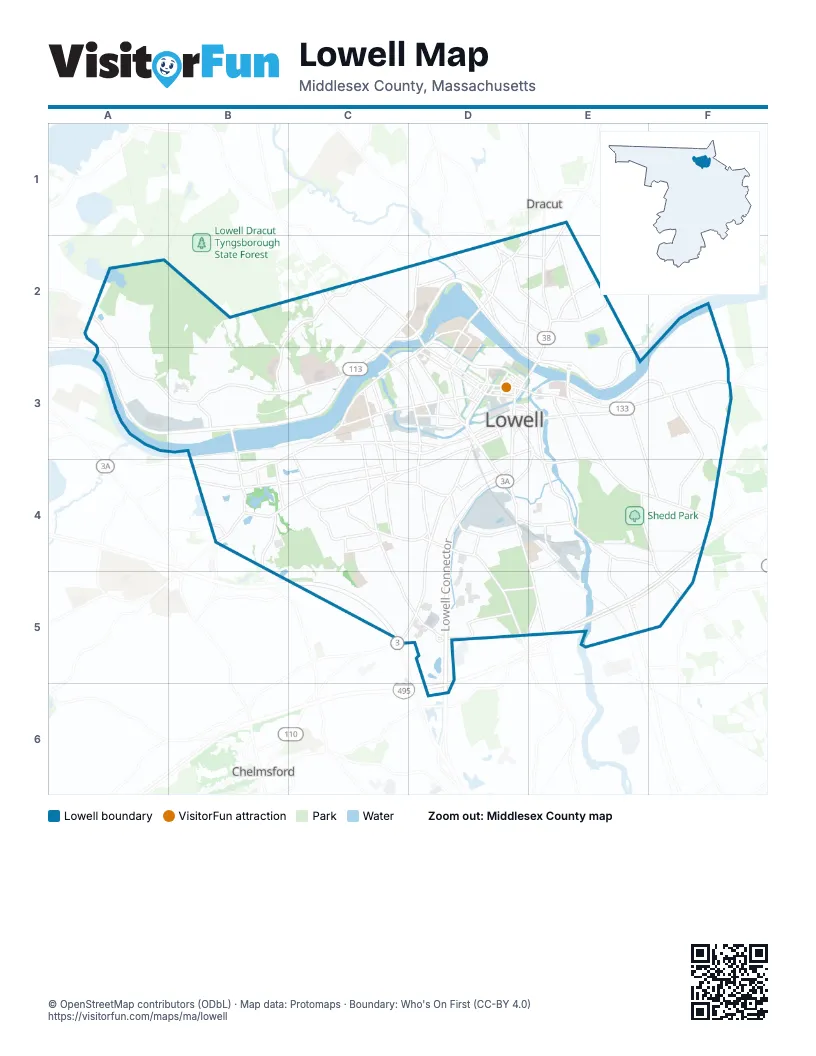
Street index of Lowell
Each street on the sheet and the grid squares it crosses.
- Lowell ConnectorD4, D5, D6
- Veterans of Foreign Wars HighwayC2, D2, C3, D3, E3
- Pawtucket BoulevardA3, B3, C3
- Varnum AvenueA2, A3, B3, C3
- Middlesex StreetB3, C3, D3, B4
- Westford StreetD3, B4, C4, D4
- Gorham StreetD3, D4, E4, E5
- Chelmsford StreetD3, D4, C5, D5
- Pawtucket StreetD2, C3, D3
- Andover StreetE3, F3
- Rogers StreetE3, E4, F4
- School StreetC3, D3, D4
- Bridge StreetE2, D3, E3
- Nesmith StreetE3, E4
- Central StreetD3, E3, D4, E4
- Thorndike StreetD3, D4
- University AvenueC2, D2
- Mammoth RoadC2, C3
- Aiken StreetD2, D3
- Rourke BridgeB3, B4
- Appleton StreetD3
- Wood StreetB4
- Main StreetD4, F4
- Church StreetD3, E3
- Hunts Falls RotaryE3
- Colonial AvenueC2
- Prescott StreetD3
- Lawrence StreetE3, E4, F4
- Stevens StreetC3, C4, C5, D5
- Princeton BoulevardB4, C4
- Father Morissette BoulevardD2, D3
- Broadway StreetC3, D3
- East Merrimack StreetE3, F3
- Lakeview AvenueD2, E3
- Pine StreetC4
- Boylston StreetE4, F4, F5
- Industrial Avenue EastD5
- Merrimack StreetD2, D3
- Riverside StreetC2, D2
- Dutton StreetD3
- Boston RoadD4, D5
- Fletcher StreetD3
- Woburn StreetE4, E5
- West Sixth StreetD2, E2
- Market StreetD3
- Plain StreetD4
- Branch StreetC3, D3
- Stedman StreetB4
- Willard StreetE1, E2
- Arcand DriveD3
- Cabot StreetD2, D3
- Salem StreetD3
- Industrial AvenueD5
- Spencer StreetD5, E5
- French StreetD3
- Perkins StreetD2
- Christman AvenueE5, F5
- Green StreetD3, E3
- North Billerica RoadF5
- Veterans WayD3
- Kearney SquareD3, E3
- Sherburne AvenueA2
- Princeton StreetB4
- Whipple RoadF5
- Drum Hill RoadB4
- Wilder StreetC3, C4
- Beacon StreetE2, E3
- Fourth AvenueC2, D5, E5
- Douglas RoadF3, F4
- Wentworth AvenueE3, F4
- West Meadow RoadB2, C2, B3
- Parker StreetC4, D4
- Hildreth StreetD2, E2
- Lincoln StreetD4
- Walker StreetC3, C4
- High StreetE3, E4
- Methuen StreetE2
- Aiken AvenueE1, D2
- Clark RoadF3
- Suffolk StreetD2, D3
- Tenth StreetE2
- Stackpole StreetE3
- Liberty StreetC4, D4
- Mount Vernon StreetC3, D3
- Sparks StreetC2, D2
- Baldwin StreetB3, B4
- Moore StreetD4, E4
- Lincoln ParkwayC4
- Powell StreetD4
- Coburn StreetD2, E2
- Meadowcroft StreetE4
- Adams StreetD3
- Swan StreetD5
- Florence RoadC4
- Rock StreetD3
- Carlisle StreetD5, E5
- South StreetD3, D4
- East Meadow RoadC2
- Hale StreetD4
- Martin StreetD2
- Fleming StreetC4
- Summer StreetD3
- Warren StreetD3, E3
- Lundberg StreetE4
- Old Ferry RoadB3
- Fisher StreetD2
- Willie StreetD3
- Highland StreetD3, D4
- Billings StreetD2, E2
- Wedge StreetC4
- Cambridge StreetD4
- Webber StreetC3, C4
- Technology DriveB4
- Rivercliff RoadF3
- Middle StreetD3
- Worthen StreetD3
- Elm StreetD3, E3
- Hadley StreetB4
- Paige StreetD3
- Essex StreetD2
- Edson StreetC4, D5
- John StreetD3
- Kirk StreetD3
- Wamesit StreetE3, E4
- Hurd StreetD3, E3
- YMCA DriveD4
- Dummer StreetD3
- Beaver StreetD2
- Shattuck StreetD3
- Cardinal O Connell ParkwayD3
- George StreetD3, E3
- Palmer StreetD3
- Sheraton WayD3, E3
- Parkhurst RoadB4
- Trotting Park RoadA2, A3
- Butman RoadE3, F3, F4
- Reiss AvenueD5
- Hovey StreetE3, F3
- First StreetE3
- Christian StreetE2, E3
- Fairmount StreetE3, E4
- Totman StreetB2, B3
- Sixth AvenueC2, D5, E5
- Raven RoadF2, F3
- Parkview AvenueE3, F3, F4
- Park Avenue EastE4
- Humphrey StreetE1, E2
- Sanders AvenueC4
- Perry StreetE3, E4
- Third AvenueC2, D5, E5
- Burnham RoadF2, F3
- Acropolis RoadB2
- Shaw StreetC4, D4
- Tanner StreetD4
- Second AvenueC2, D5, E5
- Oberlin AvenueB2, D5, E5
- Pleasant StreetE3, E4
- Concord StreetE3, E4
- Mount Hope StreetC2
- Fifth AvenueC2, D5, E5
- Foster StreetC3, C4
- Mansur StreetE3
- White StreetC2
- 18th StreetE2
- Smith StreetD3, D4
- Seventh AvenueC2
- Third StreetE3
- Crawford StreetC2
- D StreetC4, D4
- Campbell DriveC4, C5
- Dracut StreetC2
- River RoadF2, F3
- Remington StreetF3
- Trull Lane EastF2, F3
- Berkeley AvenueF4
- Ludlam StreetD2, E2
- Moody StreetD2, D3
- Jewett StreetD2, E2
- Jackson StreetD3
- Cross StreetD3
- B StreetC4, D4
- Billerica StreetE4, E5
- Westchester StreetC4, C5
- Westview RoadC4
- Freda LaneA2
- Havilah StreetF3
- Avenue CD4, D5
- Mount Pleasant StreetE2, E3
- Fort Hill AvenueE3, E4
- Upham StreetC5, D5
- Avon StreetC2
- Cumberland RoadD2
- A StreetC4, D4
- Fetherston AvenueF2, F3
- Highland AvenueC4
- Village StreetF4
- Dalton StreetD2
- Canal StreetD3, E3
- Commonwealth AvenueE5, F5
- Endicott StreetC2
- Chapel StreetD3, D4
- Virginia AvenueF2, F3
- Glenwood StreetE3, F3
- Tyler ParkC4
- Garfield AvenueD5
- Luce StreetF3
- Thornton AvenueF2, F3
- First AvenueD5, E5
- Townsend AvenueB3
- Warwick StreetC4
- Draper StreetF3
- Woodland DriveD5
- Lincoln AvenueD5
- 11th StreetE2
- Sixth StreetE2
- Columbia RoadC2
- Ennell StreetD2
- Hall StreetD2, D3
- Holyrood AvenueF3, F4
- Woodward AvenueC2, C3
- Agawam StreetE4
- Rivers Edge RoadE5
- Bunker Hill StreetD2
- Emery AvenueC2, D2
- Sayles StreetC3, C4
- Newhall StreetD4, E4
- Lexington AvenueB3
- Grove StreetC3, C4, D4
- Glenmere StreetF3
- Llewellyn StreetE2, E3
- Lowell Research Center DriveF4
- Logan AvenueD5
- Felton StreetE4, E5
- Olde Canal DriveB4, C4, B5
- Bedford AvenueB3
- Van Greenby RoadC4
- Bolt StreetE4
- Winthrop AvenueC4, D4
- Rea StreetE4, F4
- Midland StreetC4, D4
- Western AvenueD3
- Hampshire StreetE2
- New York StreetD2
- Manufacturers StreetD4
- Gershom AvenueC2
- Pheonix AvenueF4
- Black Brook DriveB4
- Howard StreetD3, D4
- Fremont StreetE2, E3
- Alcott StreetF3
- Lowes WayD5
- Marshall AvenueC5
- Gilmore StreetC2, D2
- Alma StreetD2
- West Forest StreetC5
- Quebec StreetD4
- Roper StreetE4
- Beech StreetE2, E3
- Belmont AvenueE3, E4
- Fairfield StreetC4
- Chestnut StreetE3
- West StreetD2, E2
- Myrtle StreetE2, E3
- Hoyt AvenueE4
- Fayette StreetE3
- Arch StreetD3
- Andrews StreetE4
- Bowers StreetC3, D3
- Forest StreetD4, C5
- Hanks StreetE3, E4
- London StreetD4
- Sherman StreetE3
- Mount Washington StreetD3
- Blossom StreetD4
- Farmland RoadD2
- Laurie LaneB3
- Wyman StreetE3
- Mount Grove StreetC2
- Bellevue StreetD4
- Chase AvenueC2
- Manchester StreetD4
- Frothingham StreetE3, F3
- Stafford RoadF3
- Crosby StreetD4, E4
- Orleans StreetD2
- Wannalancit StreetC3
- West Jenness StreetC5
- Belrose AvenueE4
- Barker AvenueD2, E2
- Pevey StreetC3, D3
- Avenue BD4, D5
- Francis P. McGee WayE4, F4
- Burnside StreetC3, C4
- Dingwell StreetB4
- Farragut StreetC2
- Lilley AvenueD2
- Marginal StreetC3
- Pratt AvenueB4
- Reservoir StreetE2, E3
- Hastings StreetC4
Things to do on the Lowell map
Places on the map
- Boott Cotton Mills
- Callery Park
- Campus Recreation Complex
- Cawley Memorial Stadium
- Cushing Field Complex
- Donahoe Park
- Edson Cemetery
- Encompass Health Rehab Hospital Of New England At Lowell
- Father Maguire Playground
- Festival Field
- Fort Hill
- Fort Hill Park
- Francis Gate Park
- Gage Field
- Greenway
- Hamilton Mills
- Hawk Valley Farm
- Health Science Library
- Health Sciences Library
- Highland Park
- LeBlanc Park
- Lowell Cemetery
- Lowell General Hospital
- Lowell Heritage State Park
- Mount Pleasant Golf Club
- Riverfront Park
- Saint Patrick Cemetery
- Shedd Park
- Sheehy Park
- U.S. Bunting and Crickett Club
- University of Massachusetts Lowell
- University of Massachusetts Lowell East Campus
- University of Massachusetts Lowell North Campus
- University of Massachusetts Lowell South Campus
- Wannalancit Park/Locks/Canals
- Westford Street Landfill Solar Power Facility
- Westlawn Cemetery
Next to Lowell
© OpenStreetMap contributors, Open Database License, openstreetmap.org/copyright · Map data: Protomaps · Boundary: Who's On First (CC-BY 4.0); U.S. Census Bureau















