

Massachusetts map
Middlesex County map
About 1,668,956 people live here (Census Bureau, 2024 estimate). The sheet's index lists 16 streets; Yankee Division Highway, Massachusetts Turnpike and Blue Star Memorial Highway cross the most grid squares. Things to do inside the boundary: American Heritage Museum, CambridgeSide and Charles River Boat Company.
Open the map (PDF, US Letter)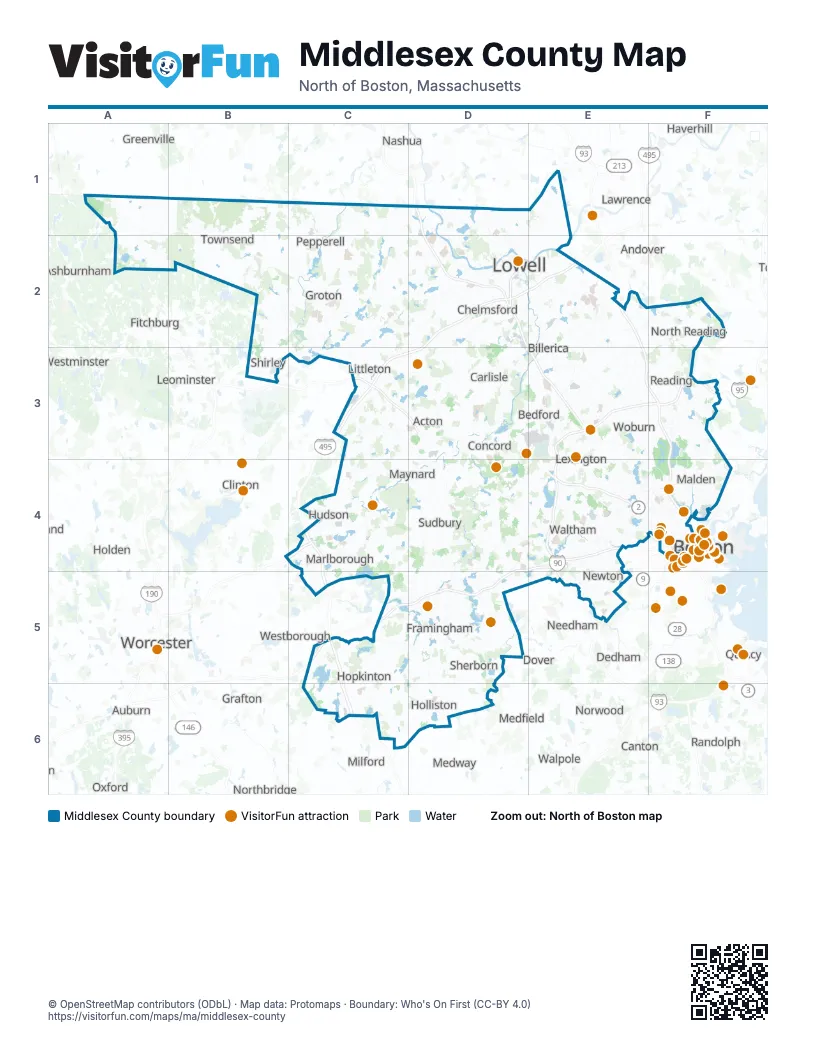
Street index of Middlesex County
Each street on the sheet and the grid squares it crosses.
- Everett TurnpikeD1
- Lowell ConnectorD2
- Captain Isaac Davis HighwayC3
- George W Stanton HighwayC3
- Yankee Division HighwayE3, F3, E4, E5
- Blue Star Memorial HighwayC4, C5
- Massachusetts TurnpikeD4, E4, C5, D5
- Cambridge Concord HighwayE4
- Concord HighwayE4
- Concord TurnpikeE4
- Bennett HighwayF4
- Leverett Circle ConnectorF4
- Leverett ConnectorF4
- Leverett Connector SouthF4
- Samuel R. Cutler HighwayF4
- Joseph A. Ferrecchia Connector RoadC5
Things to do on the Middlesex County map
- American Heritage Museum
- CambridgeSide
- Charles River Boat Company
- Harvard Art Museums
- Harvard Museum of Natural History
- Harvard Square
- Harvard Yard
- Hilton Garden Inn Boston-Burlington
- Hyatt Place Boston/Medford
- La Quinta Inn & Suites by Wyndham Boston Somerville
- Level99
- Lexington Battle Green
- MetroWest Boston
- Minute Man National Historical Park
- Nashoba Valley Ski Area
- Revolutionary Valley
- Trademark Tours
- Walden Pond
Places on the map
- Academy Hill
- Acker Conservation Land
- Acton
- Acton Arboretum
- Adams Street Conservation Land
- Adams Woods
- ADESA Boston
- Alewife Brook Reservation
- Ames Pond
- Annursnac Conservation Land
- Applewood Commercial Park
- Arlington
- Arlington's Great Meadows
- Ash Street Land
- Ash Swamp
- Ashby
- Ashby Wildlife Management Area
- Ashland
- Ashland Reservoir
- Ashland State Park
- Ashland Town Forest
- Assabet River National Wildlife Refuge
- Assabet River Trail
- Autumn Hills Orchard
- Avco
- Ayer Gun & Sportsmens Club
- Ayer Yard
- Ayer-Shirley Regional Schools
- B & M Row
- Baddacook Conservation Land
- Baddacook Pond
- Baldwin
- Barber Reservation
- Bare Meadow Conservation Area
- Bateman's Pond
- Bay Colony
- Beaver Brook Conservation Land
- Beaver Brook Estates
- Beaver Brook North Reservation
- Beaver Brook Valley Preserve
Next to Middlesex County
- Andover
- Ashburnham
- Auburn
- Boston map
- Brookline
- Canton
- Chelsea
- Clinton
- Dedham
- Devens
- Dover
- Fitchburg
- Grafton
- Greenville
- Haverhill
- Holbrook
- Holden
- Lawrence
- Leicester
- Leominster
- Lunenburg
- Medfield
- Medway
- Methuen
- Middleton
- Milford
- Millbury
- Milton
- Nashua
- Needham
- Norfolk
- Northborough
- Northbridge
- Norwood
- Oxford
- Quincy
- Randolph
- Revere
- Saugus
- Sharon
- Shrewsbury
- Southborough
- Walpole
- Westborough
- Westminster
- Worcester map
© OpenStreetMap contributors (ODbL) · Map data: Protomaps · Boundary: Who's On First (CC-BY 4.0)