

Massachusetts map
Ludlow map
About 21,118 people live here (Census Bureau, 2024 estimate). The sheet's index lists 300 streets; Center Street, Massachusetts Turnpike and Chapin Street cross the most grid squares. Also on it: Chicopee River Reservoir, Facing Rock Wildlife Management Area and Ludlow Country Club.
Open the map (PDF, US Letter)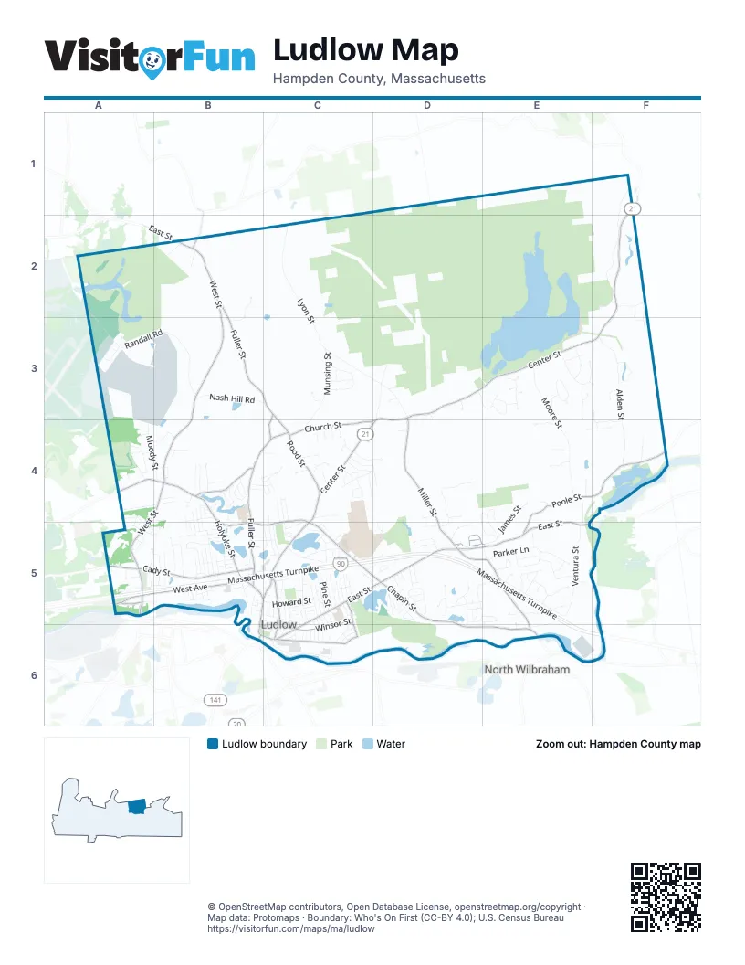
Street index of Ludlow
Each street on the sheet and the grid squares it crosses.
- Massachusetts TurnpikeA5, B5, C5, D5, E5, E6, F6
- Center StreetF1, F2, D3, E3, F3, C4, D4, B5, C5, B6
- Ludlow AvenueB6
- West StreetB2, B3, A4, B4, A5
- East StreetB2, C5, D5, E5, B6, C6
- Chapin StreetB4, C4, B5, C5, D5, D6, E6
- Miller StreetD3, D4, D5, E5, E6
- Fuller StreetB2, B3, C3, B4, C4, B5
- Holyoke StreetA4, B4, B5
- Cady StreetA5, B5
- West AvenueA5, B5, C5
- Rood StreetC3, C4
- Shawinigan DriveA5
- Russell StreetA5
- Cottage AvenueE6
- Red Bridge RoadE5
- Chauncey Walker StreetF1
- Poole StreetE4, F4, E5
- Church StreetC4, D4
- Winsor StreetC5, B6, C6
- State StreetC6
- Kendall StreetB4
- Sewall StreetC5, C6
- Stevens StreetC5, C6
- Brook StreetB2
- Taylor StreetB2
- Lyon StreetC2, C3, D3
- Ventura StreetE4, E5
- Broad Brook Canal RoadF1, E2, F2
- Moore StreetE3, E4
- Alden StreetF3, F4
- Randall RoadA3, B3
- Munsing StreetC3, C4
- Higher Brook Canal RoadD3
- Nash Hill RoadB3, C3
- Riverside DriveC6
- Westerly CircleE3, F3
- Woodland CircleE3
- Colonial DriveC3
- Perimeter RoadA2, A3
- Moody StreetA4, B4
- James StreetE4, E5
- Parker LaneE5
- Howard StreetC5
- Elizabeth DriveE5
- Tower RoadE4, E5
- Sportsman RoadC5, D5
- Cislak DriveD4, D5
- Pinecone LaneB2, B3
- Balsam Hill RoadE5
- Autumn Ridge RoadE5
- Prospect StreetC5
- Simonds StreetB5
- Stivens TerraceC5
- Turning Leaf RoadE5
- Pinewood RoadC4
- Wedgewood DriveB5
- Hubbard StreetB5, C5, C6
- Jerad DriveF3, F4
- Gamache DriveB5
- Holy Cross CircleB4
- Erin LaneB5
- Lawton StreetA4
- Clearwater CircleE3
- Americo StreetD5
- Marion CircleD4, E4, D5, E5
- Reynolds StreetD5
- Reservoir RoadD3, E3
- Southwood DriveE3
- Watson LaneE4, F4
- Sunset RidgeD4
- Laurel LaneE5
- Carmelinas CircleD5
- Pondview DriveD5, E5
- Windwood DriveE3
- Lockland StreetC5
- Booth StreetD3, D4
- Barna StreetA4, B4
- Genovevo DriveD5
- Higher Brook DriveC4, D4
- Waverly RoadE3
- Massachusetts AvenueB4, B5
- Kirkland AvenueC5
- Clover RoadC4
- Highland AvenueC5, C6
- Pine StreetC5
- Tony Lema DriveC5
- Michael StreetB4
- Oak Knolls CircleE5
- Bridle Path CircleB4
- Overlook DriveB4
- Woodside RoadC4, D5
- Yale StreetC5
- Posner CircleD5, E5
- Lakeview AvenueC5
- Edison DriveD5, D6
- Piney LaneF3
- Irla DriveD5
- Cedar StreetC5
- Swan AvenueC5
- Loopley StreetC5
- Skyridge StreetB4
- Paulding RoadC4, D4
- Karen DriveD5
- Bondsville RoadF2
- Ridgeview CircleD5
- Vienna AvenueB5
- Prokop AvenueB4, C4
- Salli CircleD5, E5
- Prospect GardensA5
- Timberidge RoadF2, F3
- Edgewood RoadC4, D4
- Minechoag HeightsE4
- Mclean ParkwayD5
- Amherst StreetC5
- Bartlett StreetD5
- Bruni AvenueA5, B5
- River StreetB5
- Letendre AvenueB5
- Laconia StreetC5, C6
- East Akard StreetC4
- Richmond RoadC4, D4
- Paine AvenueF4
- Nora LaneC4
- Coolidge AvenueA4, A5
- Wilno AvenueB5
- Ray StreetC5
- Longview CircleE5
- Daisy LaneA5
- Fox Run DriveE4
- Heritage DriveC3
- Oakridge StreetC6
- Ravenwood DriveE5, E6
- Williams StreetC5
- King StreetC5
- Wilson StreetC5
- Guertin AvenueB5
- Pine Knoll DriveC4
- Sroka LaneC4
- Ideal LaneC5
- West Akard StreetC4, C5
- Haviland StreetC5
- Blanchard AvenueB5, C5
- Dinis AvenueE5
- Harvest DriveE5
- Lavoie AvenueB4, C4
- Green StreetD5
- Focosi LaneA5, B5
- Main BoulevardA4, A5
- Knollwood RoadF2, F3
- Arnold StreetB4, B5
- Allison LaneB5
- Napoleon AvenueB4, C4
- Westover RoadA4, B4
- Warwick DriveE3
- John StreetC4, C5
- Willard AvenueB5
- Chapin Greene DriveC4, C5
- Alfred StreetB4, B5
- Grimard StreetB5
- Tank Farm RoadB4
- Bridle RoadD3
- Aldo DriveE4
- Pond StreetB5
- Dowd CourtE4
- Leland DriveC3
- Birch StreetC5
- Chapin CircleC5
- New Crest StreetD5
- Rosewood DriveC4
- Fairway DriveC6
- Parkview StreetC5
- Tilley StreetB2
- Clark StreetA4
- Barre DriveB5
- Cherry StreetB5, C5
- Grandview AvenueB5
- Bluebird CircleE5
- Homestretch DriveB4
- McKinley AvenueA5
- Roy StreetA5
- Valley View DriveB4
- Laroche StreetD5
- Waters Edge DriveB5
- Mountainview StreetC5
- Oak StreetC5
- Claudias WayD5
- Old West StreetB2
- Eldorado DriveD5
- Circuit AvenueE5
- Hunter RoadC4
- Tait StreetA5, B5
- Susan DriveE5
- Applewood DriveC4
- Glenwood StreetA5
- Meadowecrest CircleC4
- Sunbriar LaneC4
- Beachside DriveC5
- Jackie DriveD4
- Wyoming StreetA3
- C Abair StreetC5
- Avelino WayF3
- Atlantic StreetB4
- Motyka StreetB5
- Summer AvenueB5
- Fox Hill RoadC4
- Whitney StreetC5
- Brookhollow DriveC4
- Davis StreetB5
- Hill TerraceD5
- Meadowlark CircleD4
- Arthur StreetB4, B5
- Equinox PassE5
- Gaudreau AvenueB5
- White StreetC5
- Georgetown RoadB4
- Szlosek RoadA4
- Bowles AvenueD5
- Fairview StreetA5, B5
- Harris LaneB4, B5
- Maria's WayD5
- Deer Hill CircleE5
- Briarwood LaneC4
- Helene StreetD5
- Andrew StreetB4, B5
- Mariana LaneA5
- Cardinal CircleB4, C4
- McDonald CircleE5
- Chestnut StreetC6
- Letourneau StreetA3
- Old Coach CircleC4
- Newbury StreetC5, C6
- Pallet WayA4, B4
- Worcester StreetC6
- Margaret LaneE4
- Stivens DriveC5
- Turnpike Service RoadC5, D5
- Brookhaven DriveC5
- Charles StreetA4, B4
- Ampere AvenueD5
- Power AvenueD5
- West Orchard StreetB5
- Railroad StreetC5
- Voltage AvenueE5
- Spring Meadow DriveC4
- Deroche CircleB4
- Franklin StreetC6
- Keefe StreetB4
- Elm StreetC5
- Pine Glen DriveD3
- Maple StreetC5
- Wood DriveC4
- Dale StreetD5
- Evergreen CircleB5
- Isabel LaneE5
- Owens WayE5
- Crest StreetD5
- Lehigh StreetC5
- Norwich RoadD4
- West Belmont StreetB5
- Eden StreetD5
- Essex StreetC6
- Manor LaneC3
- Pleasantview StreetC5
- Bluegrass LaneB4
- Emma WayA5
- Scott StreetB4
- Northwood CircleE3
- Pleasant StreetC5, D5
- Robin DriveD3
- Keith CircleB4
- Libby StreetB4
- Munsing AvenueB4
- Funston AvenueB5
- Warsaw AvenueC5
- Duke StreetC6
- Olivia CircleC4
- Blisswood Village DriveB5
- Park PlaceC6
- Florida StreetB5
- Lillian StreetB5
- Goddu StreetB5
- Deponte DriveE4
- Hampden StreetC6
- Tyburski RoadA4
- Ronald StreetB5
- Adams StreetC5
- Bramucci StreetC5
- Bristol StreetC6
- Greenwich StreetC5
- Oakwood DriveD5
- Lawrence StreetC5
- Berkshire StreetC6
- Crescent DriveC5
- Higher StreetC5
- Meadow StreetC6
- Hillcrest LaneE5
- Hampshire StreetC6
- Longfellow DriveE3
- Morse StreetB5
Places on the map
- Alden Pond
- Camp White Conservation Area
- Chicopee River Reservoir
- Driving Range
- East Street Elementary School
- Facing Rock
- Facing Rock Wildlife Management Area
- Gamache Pond
- Harris Brook Elementary School
- Harris Pond
- Haviland Pond
- Haviland Pond Beach
- High Hill
- Hubbard Memorial Library
- Island Pond Cemetery
- Jefferson Peak
- Lane Property
- Ludlow Country Club
- Ludlow Public Schools
- Ludlow Reservoir
- Ludlow Reservoir Wildlife Conservation Easement
- Ludlow Service Plaza Eastbound
- Ludlow Service Plaza Westbound
- Ludlow State Forest
- Ludlow Town Hall
- Minechoag Mountain
- Minechoag Pond
- Murphy Pond
- Nash Hill Reservoir
- Pickerel Pond
- Red Bridge State Park
- Reservoir Cemetery
- Reynolds Pond
- Rock Rimmon
- Town Forest
- Troop 180 Camp
- Wade Pond
- Westover Conservation Area
- Westover Golf Course
- Whitney St. Park
Next to Ludlow
- North Wilbraham
© OpenStreetMap contributors, Open Database License, openstreetmap.org/copyright · Map data: Protomaps · Boundary: Who's On First (CC-BY 4.0); U.S. Census Bureau















