

Massachusetts map
North Adams map
About 12,492 people live here (Census Bureau, 2024 estimate). The sheet's index lists 300 streets; Notch Road, State Road and Mohawk Trail cross the most grid squares. Things to do inside the boundary: MASS MoCA and Natural Bridge State Park.
Open the map (PDF, US Letter)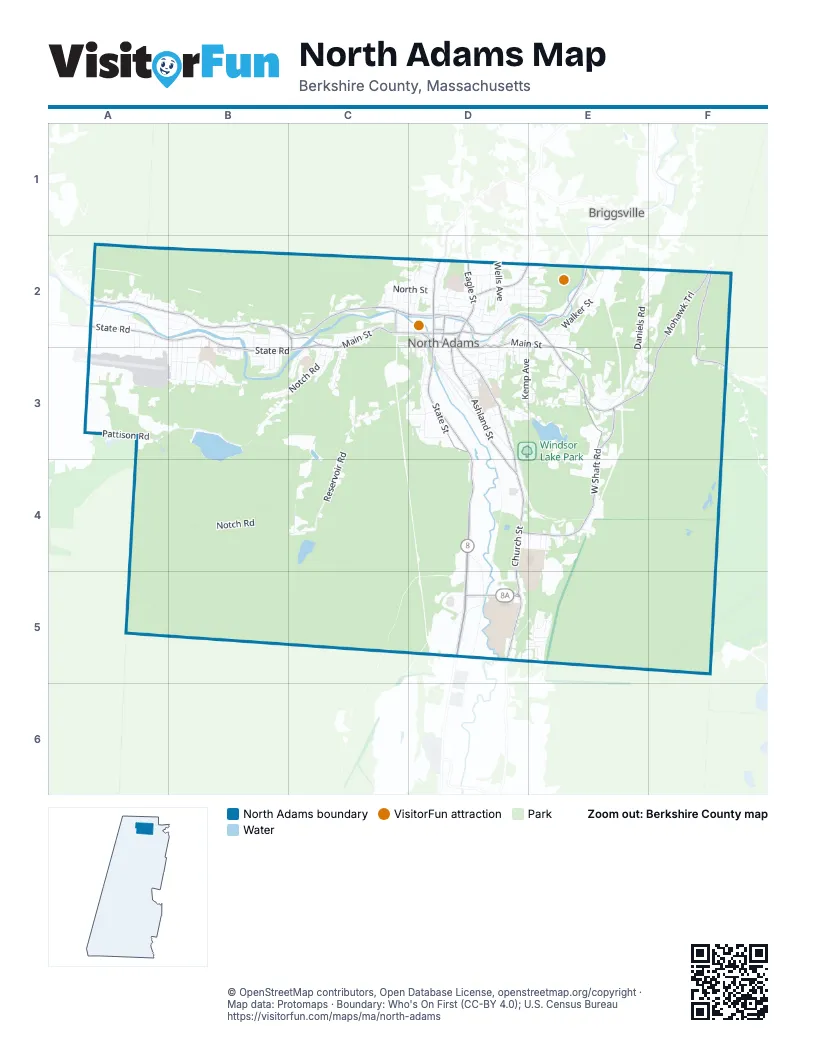
Street index of North Adams
Each street on the sheet and the grid squares it crosses.
- Mohawk TrailE2, F2, E3, F3
- Curran Memorial HighwayD3, D4, D5
- State RoadA2, B2, C2, B3, C3
- West Main StreetC2, D2, C3
- State StreetD2, D3
- Union StreetD2, E2
- Main StreetA2, D2
- Veterans Memorial DriveD2
- Holden StreetD2
- Marshall StreetD2
- Saint Anthony's DriveD2
- Church StreetD2, D3, D4, D5
- Ashland StreetD2, D3, D4
- Beaver StreetE2
- Eagle StreetD2
- Hodges Cross RoadD5
- North Church StreetD2
- Massachusetts AvenueA2, B2, C2
- West Shaft RoadE3, D4, E4
- East Main StreetD2, E2, D3, E3
- River StreetC2, D2
- Franklin StreetD2
- Houghton StreetD2
- Roberts DriveB2, C2, C3
- Brown StreetC2
- Canal StreetD2
- North Eagle StreetD2
- North Houghton StreetD2
- Notch RoadC2, B3, C3, A4, B4, C4, A5, B5
- Reservoir RoadC3, D3, C4
- Pattison RoadA3, B3
- Daniels RoadE2, F2, E3
- South State StreetD4, D5
- Walker StreetE2
- Kemp AvenueD2, D3, E3
- Wells AvenueD2
- Walnut StreetD3
- Barbour StreetB3
- Sterling DriveD5, E5
- McCauley RoadE2
- Protection AvenueB2, B3
- Mohawk Forest BoulevardE3
- Windsor Lake RoadD3, E3
- Richview AvenueC2, C3
- Prospect StreetD2
- Phelps AvenueB2, B3
- East Quincy StreetD3
- North StreetC2, D2
- Veazie StreetD2
- Seminole DriveE5
- Marion AvenueC2, C3
- Whitney Sand Bed RoadC2
- Liberty StreetD2
- Chantilly AvenueB2, B3
- Catherine StreetB3
- Versailles AvenueB2, B3
- Christopher Columbus DriveD3
- Oak HillE3
- Hawthorne AvenueB2, B3
- Bracewell AvenueD2
- Summit AvenueD2, D3
- Furnace StreetD3
- Meadow StreetD3
- East AvenueD2, E2
- American Legion DriveD2, D3
- Brayton Hill TerraceC3
- Charlene StreetD2, E2
- Rich StreetD3, E3
- Bradley StreetD3, E3
- Harding AvenueB3
- Cliff StreetD2
- Brooklyn StreetD2
- Ashton AvenueA2
- Amidon RoadA2, B2
- Crest StreetE2
- Barth StreetD2
- Brayton StreetA2, E2, A3
- Gallup StreetD2
- Greylock AvenueB2, B3
- Corinth StreetD3
- Old Mohawk TrailE3
- Hall StreetD2
- Woodlawn AvenueB3, C3
- Harris StreetC2
- Old State StreetD5
- Apache DriveE5
- Tremont StreetD2
- North Holden StreetD2
- Galvin RoadA2
- Francis StreetD3
- Brickyard CourtC3
- Gunther StreetD3
- New StreetB3
- Dean StreetD3
- Barlow AvenueC3
- Demond AvenueB2, B3
- Chenaille TerraceA2, A3
- Miner StreetD2, D3
- Natural Bridge RoadD2, E2
- Hospital AvenueD2
- Old Union StreetE2
- Alan DriveE5
- Barbour Street ExtensionB3
- Autumn DriveE3
- Lois StreetA2, A3
- Bonair AvenueB3
- Front StreetD2
- Maple StreetD2, E2
- Porter StreetD3
- Glen AvenueD2
- Park AvenueD2, D3
- Richmond AvenueC2, D2
- Center StreetD2
- Blackinton StreetD3
- Washington AvenueD3
- Pleasant StreetD3
- Cherry StreetD3
- Willow Dell StreetD2
- Hathaway StreetC2
- Parker StreetD2
- Marietta StreetD2
- Montana StreetD3
- Tyler StreetC2
- College AvenueB3
- Elmwood AvenueD3
- Chase AvenueD2
- Williams StreetD2
- Lyman StreetC3, D3
- Holbrook StreetD3
- Meade AvenueB3
- Central AvenueD2
- Cady StreetC2
- Canedy LaneE2
- Davenport StreetD3
- Yale StreetD3
- Spring StreetD3
- Biltmore AvenueB3
- Birchwood TerraceE3
- Summer StreetD3
- Aztec DriveE5
- Frederick StreetD2
- Walden StreetC2
- High StreetD2, D3
- Clark StreetB2
- Northern Lights AvenueD2
- A StreetD4
- Lincoln StreetD2
- B StreetE4
- Fortin AvenueD3, E3
- Whitman StreetD2, D3
- Folsom StreetD2
- Montgomery StreetD2
- D StreetE4
- Olds StreetB2
- George AvenueA2
- Murray AvenueE2
- Cleveland AvenueD2, E2
- Bradford StreetD3
- Orchard HillE3
- C StreetE4
- Foucher AvenueB3
- Church HillA2, B2
- Furnace Street BypassD3
- Arnold PlaceD3
- Myers AvenueC2, D2
- Elder AvenueD2
- Dover StreetD3
- Bryant StreetD2
- Johnson StreetE2
- Richview Avenue ExtensionC3
- Oak AvenueD3
- South StreetD3
- West End TerraceC3
- Grimes StreetC2
- Winter StreetD3
- Bliss StreetD2
- Millard Avenue ExtensionD2
- Jackson StreetD2
- Millard AvenueD2
- Monroe StreetE2
- Rand StreetD2
- First StreetC3
- Taft StreetB3
- Edgewood AvenueA2
- Bluff RoadE2
- Burnham StreetE2
- Lorraine DriveD2
- East Johnson StreetE2
- Chase HillD2
- Beacon StreetD2
- Charles Street ExtensionC2
- Pinehill TerraceE3
- Windom TerraceD3
- Mark LaneE3
- Temple StreetC2
- Navajo DriveE5
- Reed StreetD2
- Watson StreetB3
- Chestnut StreetD3
- Dorothys WayE3, F3
- Wall StreetD3
- Beech StreetD2
- School StreetC2, D2
- Angeli StreetB3
- Willow StreetD3
- Wesleyan StreetD2
- Isbell StreetB3
- Quincy StreetD3
- Hudson StreetD2
- Leonard StreetA2
- Sperry AvenueD2
- Spencer RoadE3
- Adams StreetC2
- Labonte AvenueE4
- Mill StreetA2
- West Shaft Road TerraceE3
- Royal AvenueD3
- Sullivan StreetB3
- Iroquois DriveE5
- Ivory StreetD3
- Wood StreetA2
- Goodrich StreetC2, C3
- Bradley Street ExtensionE3
- Gattuso DriveD3
- Whittesley AvenueB2
- Mundy TerraceE3
- Secor AvenueD2, D3
- Milton DriveE3
- E StreetE4
- Hudson Brook LaneE2
- Pitt StreetD2
- Greene AvenueB3
- Duane AvenueE3
- Hoosac StreetD3
- Nelson StreetD2
- Gregory AvenueD2
- Crowley AvenueD3
- Fuller StreetD2
- Sutton StreetB3
- Doanes LaneB2
- Highland AvenueD3
- Perry StreetD3
- The Speed WayD2
- Duggan StreetC2
- Palmer AvenueC2
- Ray StreetD2
- Harrison AvenueD3
- Chesbro AvenueD2
- Pebble StreetD3
- Rickards StreetA2
- Crossey PlaceC2, D2
- Sylvester StreetA2
- Citation AvenueE2
- Davidson StreetA2
- Kateley LaneA2
- Overlook TerraceD3
- Classic AvenueE2
- Bridge StreetD2
- Fleming StreetD3
- Owens AvenueD2
- Briggs StreetD2
- Avon StreetC2
- Comanche DriveE5
- Fairgrounds AvenueC2
- Grant StreetB3
- Lake StreetD3
- Pershing StreetC3
- Hooker StreetD3
- Lamoureaux PlaceD2
- Bond StreetD3
- Irving AvenueC3, D3
- Estes StreetD2
- Whitney AvenueD3, E3
- Brook TerraceD2
- Cherokee DriveE5
- Freeman AvenueD2
- Russell StreetB2
- Grove StreetD2
- Laurel AvenueD2
- Hermon AvenueD2
- Benedict StreetD3
- Berkshire Bank Drive-ThroughD2
- Orchard TerraceD2
- Morgan AvenueD3
- Warren StreetC2, C3
- Lewis PlaceD2
- Addison AvenueB2
- Charles StreetC2
- Rock StreetD3
- Raymond CourtD2
- Alton PlaceC2
- MASS MoCA WayD2
- Loftus StreetC2
- Robinson StreetD3
- Forest StreetD2
- Deborah DriveD2
- Granite StreetD3
- Seneca DriveE5
- Whitley AvenueD2
- Bethel StreetD2
Things to do on the North Adams map
Places on the map
- Alcombright Field
- Ashley Swift Plumbing and Heating
- Aubuchon Hardware
- Benchmark Kitchens
- Berkshire Transmissions
- Bethel Pentecostal Church
- Big Y
- Blackington Manor
- Brayton Elementary School
- Camp Decker
- Charles H. McCann Technical School
- Dr. Robert J. Carpenter Memorial Library
- Drury High School
- Greylock School
- Harriman-and-West Airport
- Hillside Cemetery
- Historic Valley Campground
- Hoosac Range
- Hoosic River Access
- Massachusetts Museum of Contemporary Art
- MCLA Joseph Zavattaro Athletic Complex
- Mount Williams
- Mount Williams Reservoir
- Mount Williams Watershed
- Natural Bridge State Park
- Noel Field Athletic Complex
- North Adams Center
- North Adams City Hall
- North Adams Gateway Center
- North Adams Post Office
- North Adams Regional Hospital
- Notch Reservoir
- Saint Joseph's Cemetery
- Southview Cemetery
- Spruce Hill
- The Cascades
- Upper/Lower Reservoir
- Walmart Supercenter
- Windsor Lake
- Windsor Lake Park
Next to North Adams
- Briggsville
© OpenStreetMap contributors, Open Database License, openstreetmap.org/copyright · Map data: Protomaps · Boundary: Who's On First (CC-BY 4.0); U.S. Census Bureau















