

Massachusetts map
South Hadley map
About 18,031 people live here (Census Bureau, 2024 estimate). The sheet's index lists 300 streets; Amherst Road, Woodbridge Street and Hadley Street cross the most grid squares. Also on it: Bynan Conservation Area, Connecticut River Reservoir and Ledges Golf Club.
Open the map (PDF, US Letter)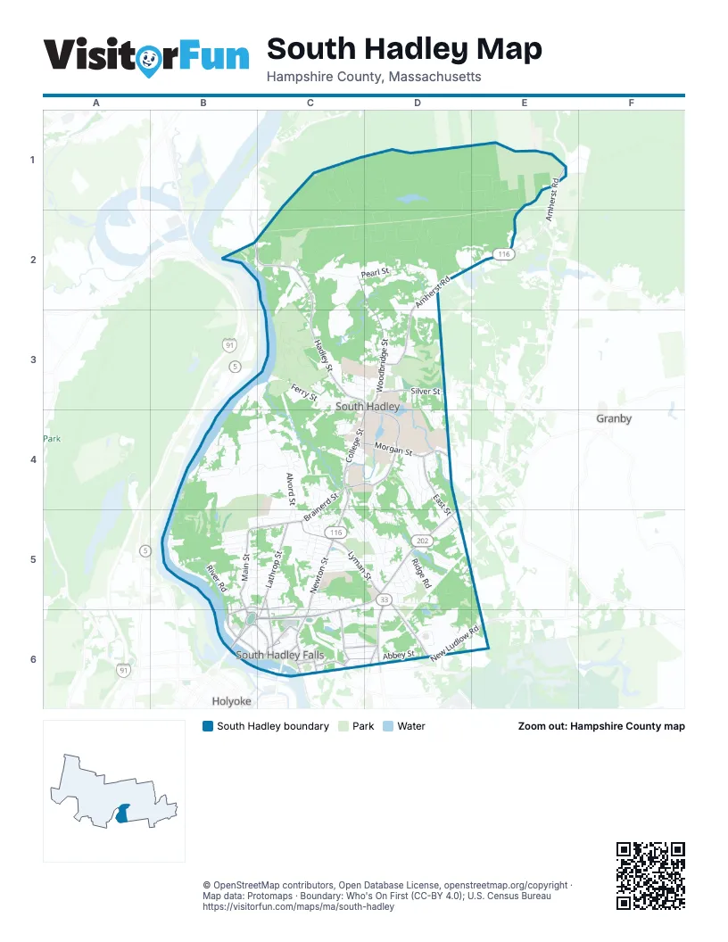
Street index of South Hadley
Each street on the sheet and the grid squares it crosses.
- Purple Heart DriveB6, C6
- Amherst RoadE1, D2, E2, D3
- Granby RoadC5, D5, C6
- Woodbridge StreetC2, D2, D3, D4
- Newton StreetC4, C5, C6
- Lyman StreetC5, D5
- Willimansett StreetD5, D6
- College StreetD3, C4, D4
- Lamb StreetC6
- Purple Heart Drive RotaryB6
- Memorial DriveD6
- Bridge StreetC6
- West State StreetD5
- Hadley StreetB2, C2, C3, D3
- North Main StreetB5, B6, C6
- Old Lyman RoadD5, D6
- Silver StreetD3
- New Ludlow RoadD6, E6
- Main StreetC6
- South Main StreetC6
- Syrek StreetC6
- Hockanum RoadB2
- Montcalm StreetD6
- East StreetD4, D5
- Brainerd StreetC4, B5, C5
- Morgan StreetC4, D4
- Lathrop StreetC5, C6
- Mosier StreetC4, D4
- Canal StreetB5, B6, C6
- Park StreetD3, D4
- Bardwell StreetC5, C6
- Hillside AvenueC6
- Ludlow RoadC6
- Gaylord StreetC6
- West Summit StreetB5, C5, B6, C6
- Summit StreetC5, C6
- Hollywood StreetC6, D6
- Laurie AvenueC6, D6
- Carew StreetC6
- Spring StreetC6
- Bolton StreetC6
- Hartford StreetC6
- West Main StreetC6
- Paul StreetC6
- Alvord StreetC3, C4, C5
- Pearl StreetC2, D2
- San Souci DriveB4, C4
- River RoadB5
- Upper River RoadB4, B5
- Ferry StreetC3
- Alvord PlaceC4
- Mulligan DriveB4, C4, B5
- River Lodge RoadB4, C4
- Abbey StreetD6
- Pittroff AvenueD5
- Skinner State Park RoadC1
- Westbrook RoadD4
- Pine StreetC4
- Lyman TerraceD5
- Shadow Brook EstateC6
- Ashton LaneD4, D5
- Industrial DriveD6
- Bagg RoadB4, C4
- The MeadowsD3
- Charon TerraceD4
- Ridge RoadD5
- Chapel Hill DriveD3, D4
- Hildreth AvenueC5, D5
- Lincoln AvenueC5
- Boynton AvenueC5, D5
- Mountain View StreetD4, D5
- Sunset AvenueD5
- Pine Grove DriveD5
- Jewett LaneC4
- Cedar RidgeB5, C5
- Cove Island RoadB5
- Priestly Farms RoadC3
- Prospect StreetC5, C6
- Cemetery AvenueC6
- Mary Lyon DriveD4
- Chestnut Hill RoadB5
- Camden StreetC5
- Tampa StreetC6, D6
- Lower Lake RoadD4
- Pearl LaneC2, C3
- Brockway LaneC3, C4
- College View HeightsD3, D4
- Woodbridge TerraceD3
- Richview AvenueC5, D5
- Saybrook CircleD4
- Washington AvenueC5
- Silverwood TerraceD3
- Edison DriveD4
- Ashfield LaneC4
- Kimberly DriveC5
- Michael DriveC6, D6
- Judd AvenueB5, C5
- Fairview StreetC5
- Bayon DriveB5
- Grandview StreetC6
- Wildwood LaneD5
- Titans Pier RoadB2, C2
- McKinley AvenueC5
- Pheasant RunB5
- Spring MeadowsB4, C4
- Riverboat Village RoadB4
- Pumping Station RoadD2
- High StreetC6
- Highland AvenueB5, C5
- Stonybrook WayC5
- Pine Hill RoadC5, C6
- Susan AvenueC6, D6
- Red Bridge LaneD4
- School StreetC6
- The KnollsD3
- South Sycamore KnollsC3, D3
- Taylor StreetB6, C6
- Hillcrest ParkC6
- Gateway RoadC4, D4
- Stonegate DriveC4
- Viviani StreetC5
- Brigham RoadD5
- North Sycamore KnollsC3, D3
- Reservoir RoadC6, D6
- Lyon GreenD4, D5
- Searle RoadB5
- Virginia DriveD4
- Columbia StreetD5
- Sullivan LaneC2
- Valley View DriveB5
- Dartmouth StreetD5
- Karen DriveD5
- Berwyn StreetC5
- Woodlawn StreetD5
- Los Angeles StreetC6, D6
- West Parkview DriveD4, D5
- Parker StreetD5
- Sycamore KnollsC3, D3
- Carriage LaneD5
- Cypress DriveD4
- Leahey AvenueC4
- Mandelle Hall RoadD4
- Roosevelt AvenueC5
- Eagle DriveD6
- Ranger StreetC5
- Kenlee GardensB6
- Hadley Village RoadD5
- Lawn StreetC5
- Parkview DriveD4
- Noel StreetC5, D5
- Rivercrest WayC3, C4
- Joffre AvenueC5
- Stanton AvenueC4, D4
- Steven DriveC4, C5
- Blueberry BendD5
- Falls WoodB5, B6
- Fulton StreetC5
- Bach LaneD2
- Waite AvenueB5, C5
- Blanchard CircleD4
- Lithia Springs RoadD2
- Magnolia TerraceC5
- Dale Street ExtensionD5
- Dunlap PlaceD3
- Skyline DriveC4
- Applewood LaneB5, C5
- The Knolls StreetD3
- Garden StreetC5
- Pynchon RoadB5, C5
- Crystal LaneC5
- Sycamore ParcC3
- Baker StreetC6, D6
- Dove HillC4
- North StreetC6
- Edgewater LaneB4
- Country LaneD4
- Easy StreetD5
- Meadow LaneD3
- Maple StreetB6
- Wilson StreetC5
- Worthington DriveB5
- Old County RoadD2
- Smith StreetC6
- Lexington StreetC5
- Landers StreetC5
- Pershing AvenueC5
- Meadowood DriveC4, C5
- Dale StreetD5
- Fairlawn StreetC5
- Doane TerraceC4
- Kendrick StreetC5
- East Red Bridge LaneD4
- Henry RoadD5
- South StreetC6
- Berwyn Street ExtensionC5
- Linda StreetC5, C6
- Conti DriveD5
- Bartlett StreetD5, E5
- Mountain AvenueC5
- Pheasant LaneC4
- Wood AvenueC5
- Jacob WayC5
- Midway StreetC5
- Chileab RoadD3
- Central AvenueC6
- Meadowood Drive ExtensionC4
- Oakwood CircleD5
- Park AvenueC5
- Stewart StreetD6
- Pleasant StreetC6
- Leblanc DriveC5
- White Brook LaneB5
- Brittany RoadB5
- Camp Perkins RoadD2
- Kohler RoadD4
- McDowell DriveD5
- Roundelay RoadD4
- Brook RoadD4
- Helm StreetD5
- Yale StreetD5
- Normandy RoadB5
- Forest DriveD5
- Harvard StreetD5
- Lawrence AvenueC6
- Plainville CircleD6
- Sorbi CircleD2
- Strong Farm LaneB5
- Carol Ann DriveD5
- Apple RoadD5
- Haig AvenueC5
- Sunrise CircleB4, C4
- Spring Street ExtensionC6
- Brock WayC4
- Red Ledge RoadD3
- Carlton StreetC5
- Briar Spring LaneB4
- Benoit LaneD5
- Lorraine AvenueC5, C6
- PineshedC4
- Lawler DriveD6
- Hunter TerraceC5
- Lombard StreetD6
- Atwood RoadD3
- Chapin RoadC4, D4
- Cordes CourtC6
- Wooley CircleC4, D4
- Queen CircleC5
- Wellesley CircleD3
- Tigger LaneB5
- Cornell StreetD5
- Hillcrest AvenueC5, C6
- Faculty LaneC4
- Cote BoulevardC6
- Burnett AvenueC4
- Miller AvenueD5
- Woodcrest LaneD5
- Dayton StreetC5
- Buttonfield LaneC4
- Wright PlaceC4
- Glenn DriveD5
- Young CircleC5
- John LaneC6
- Birch Hill RoadD3
- Chatham WayC2
- Belmont AvenueC4, C5
- Promenade WayB4
- Benger AvenueD5
- Lansing AvenueC5
- Oakley DriveC5
- Scott Hollow DriveC5
- Bittersweet LaneD3
- The OrchardsD3
- Agnes Loder WayC4
- Foch AvenueC5
- Grant StreetC6
- Abbey LaneD6
- Riverwood TerraceB5, B6
- Ohm CircleD4
- Elm StreetC6
- Oak AvenueD5
- Crescent LaneC6
- Dickinson Farm RoadD3
- Broad StreetC5
- Rockefeller RoadC4, D4
- Bunker Hill StreetC5
- Greenwood LaneD3
- Linden DriveC6
- Prospect Hall RoadD4
- Old Plains HollowC5, D5
- Cedar Ridge RoadC5
- Walnut StreetC6
- Taylor WayC5
- Frederick PlaceB5
- Pasadena StreetC6
- Ann StreetD6
- Brook StreetD5
- Misty CourtB4
- Skinnerwoods WayD2
- Lois AvenueD5
- Margaret StreetD5
Places on the map
- Bachelor Brook/Stony Brook Resource Area
- Beachgrounds Park
- Black/Stevens Conservation Area
- Brunelles Marina
- Buttery Brook
- Buttery Brook Park
- Bynan Conservation Area
- Camp Lewis Perkins
- Connecticut River Reservoir
- Conservation Land
- Dry Brook Hill
- Evergreen Cemetery
- Hadley Falls Canal Park
- Itner Smith Property
- Jones Newton Property
- Joseph Allen Skinner State Park
- Leaping Well Res.
- Leaping Well Reservoir
- Ledges Golf Club
- Lithia Springs
- Lithia Springs Reservoir
- Loomis Village
- Lower Pond
- Lyman Conservation Restriction
- Michael E. Smith Middle School
- Miles-Smith Science Library
- Mosier Elementary School
- Mount Holyoke College
- Mount Holyoke Range Conservation Area
- Notre Dame Cemetery
- Orchards Golf Club
- River to Range Trail
- Saint Rose Cemetery
- South Hadley High School
- South Hadley Landfill
- Stone Hill Conservation Area
- Town Farm
- Upper Pond
- Warner Conservation Area
Next to South Hadley
- Granby
- Holyoke map
© OpenStreetMap contributors, Open Database License, openstreetmap.org/copyright · Map data: Protomaps · Boundary: Who's On First (CC-BY 4.0); U.S. Census Bureau















