

Massachusetts map
Holyoke map
About 37,838 people live here (Census Bureau, 2024 estimate). The sheet's index lists 58 streets; Northampton Street, Cherry Street and Main Street cross the most grid squares. Things to do inside the boundary: Canna Provisions and Holyoke Mall.
Open the map (PDF, US Letter)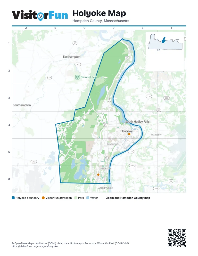
Street index of Holyoke
Each street on the sheet and the grid squares it crosses.
- North StreetD1
- Northampton StreetD1, E1, D2, E2, D3, D4, D5
- Easthampton RoadC3, C4, D4
- Southampton RoadC3, B4, C4
- Bemis RoadD3, C4, D4
- Mountain Park RoadD3
- Pleasant StreetD3, D4
- River TerraceD3
- County RoadB4, B5
- Rock Valley RoadB4, B5, C5
- Ross RoadB4
- Cherry StreetC4, D4, C5, D5
- Homestead AvenueC4, C5, C6
- Jarvis AvenueC4, D4
- Mountain RoadC4, B5, C5
- Appleton StreetD4, E4, E5
- Beech StreetD4, D5
- Cabot StreetD4, D5, E5
- Commercial StreetD4, D5
- Dwight StreetD4, E4
- Easthampton Road WestD4
- Hampden StreetD4, E4
- Hampshire StreetD4, D5
- High StreetD4, E4, D5
- Hillside AvenueD4, D5
- Lincoln StreetD4
- Linden StreetD4
- Lyman StreetD4, E4
- Maple StreetD4, E4, D5
- Nick Cosmos WayD4
- Purple Heart DriveD4
- Resnic BoulevardD4, D5
- Sargeant StreetD4, D5, E5
- West Franklin StreetD4
- Woods AvenueD4
- Canal StreetE4
- Main StreetE4, D5, E5, D6
- North Bridge StreetE4
- North Canal StreetE4, E5
- Race StreetE4
- Apremont HighwayB5, C5
- North RoadB5
- Westfield RoadB5, C5, D5
- Whiting Farms RoadC5, D5, C6, D6
- Brown AvenueD5
- Hitchcock StreetD5
- Ingleside StreetD5, D6
- Jackson StreetD5
- Kay AvenueD5
- Laurel StreetD5
- South Canal StreetD5, E5
- South StreetD5
- Willimansett BridgeE5
- Bobala RoadC6
- Holyoke StreetC6, D6
- Lower Westfield RoadC6, D6
- Mall DriveC6, D6
- Whitney AvenueC6, D6
Things to do on the Holyoke map
Places on the map
- Ashley Cutoff
- Ashley Pond
- Ashley Watershed
- Bear Hole Watershed
- Beaudoin Village
- Bradley Mountain
- Broad Brook
- Calvary Cemetery
- Cedar Knob
- Cherry Hill
- Clear Pond
- Community Field
- Connor Reservoir
- Crafts Hill
- Crosier Field
- Deadtop
- Devonshire Place Apartments
- Dinosaur Footprints
- Dry Knoll
- E.N. White Elementary School
- East Mountain Wildlife Management Area
- Echo Hill Townhouse Apartments
- Forestdale Cemetery
- Gloutack Park
- Goat Peak
- Hampden County
- Highland Dingle
- Holyoke
- Holyoke Canoe Club
- Holyoke City Hall
- Holyoke Community College
- Holyoke Community College Library
- Holyoke Country Club
- Holyoke Crossing
- Holyoke Heritage State Park
- Holyoke High School
- Holyoke Mall
- Holyoke Medical Center
- Holyoke Shopping Center
- Jarvis Heights
Next to Holyoke
- Ashleyville
- Easthampton
- Fairview
- South Hadley
- South Hadley Falls
- Southampton
© OpenStreetMap contributors (ODbL) · Map data: Protomaps · Boundary: Who's On First (CC-BY 4.0)