

Massachusetts map
Westford map
About 25,024 people live here (Census Bureau, 2024 estimate). The sheet's index lists 300 streets; Main Street, Groton Road and Littleton Road cross the most grid squares. Things to do inside the boundary: Nashoba Valley Ski Area.
Open the map (PDF, US Letter)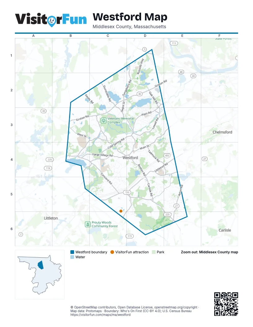
Street index of Westford
Each street on the sheet and the grid squares it crosses.
- Groton RoadC2, D2, B3, C3
- Littleton RoadD4, E4, C5, D5
- Acton RoadE5, E6
- Concord RoadC4, C5, D5
- Main StreetD2, D3, E3, C4, D4
- Carlisle RoadD4, D5, E5, E6
- Depot StreetC2, C3, D3, D4
- Tyngsboro RoadD1, C2, D2
- Plain RoadD2, D3
- Dunstable RoadD1, C2, C3
- Forge Village RoadB4, C4
- Powers RoadD5, C6, D6
- Boston RoadD4
- Graniteville RoadC3, C4
- South Chelmsford RoadD4, E4
- Oak Hill RoadD2
- North Main StreetB3, C3, B4
- East Prescott StreetB4
- Pleasant StreetB4, C4
- North StreetC3
- Brookside RoadD2, D3
- West Prescott StreetB4
- River StreetC3
- Bridge StreetC3
- Nabnasset StreetD2
- Pine StreetB4
- Parkerville RoadE4
- North Street ExtensionC3
- Old Westford RoadE3
- Lowell RoadD3, E3
- Cold Spring RoadC3, D3, C4
- Old Lowell RoadE4, D5, E5
- Tadmuck RoadD4, E4
- West StreetB3, C3, E6
- Beaver Brook RoadB4, C4, B5
- Patten RoadC4
- Makepeace RoadD1
- Moore RoadD3
- Blaney StreetE6
- Burbeck WayD3
- Russells WayD1, D2
- Keyes RoadB2, C2, C3
- Hildreth StreetC4, D4, C5
- Providence RoadD3, D4
- Nutting RoadC3, D3
- Stony Brook RoadD3
- Chamberlain RoadD3, E3
- Forrest RoadD2
- Village View RoadB4
- Tenney RoadC2
- Stone Ridge RoadC1, D1, C2
- Griffin RoadD5, E5
- Lakeside TerraceD2, C3, D3
- Buckboard DriveE3, D4
- Monadnock DriveC5
- Vose Hill RoadE5, E6
- Flagg RoadC4
- Pine Ridge RoadC3, C4
- Chicory RoadC5
- Magnolia DriveC5
- Princeton WayE4
- Pine Hill RoadE3, E4
- Colonial DriveE5
- Kirsi CircleD3, D4
- Cowdry Hill RoadB3
- Nashoba Ski Area RoadC5, C6
- Vose RoadE4, D5, E5
- Misty LaneD5
- Texas RoadD5, D6
- Robinson RoadC4
- Newport DriveD3
- Old RoadE6
- Blanchard LaneC4
- Phillips DriveC5
- Blakes Hill RoadD4
- Almeria CircleD3
- Endmoor RoadD2, D3
- Crown RoadD4
- Country RoadC4
- Howard RoadC5
- Leland RoadD4
- Vine Brook RoadD5, D6
- Greenwood RoadE5
- Fletcher RoadC3, D3, C4
- North Hill RoadC2, D2
- Steeple Chase CircleD5
- Chippewa RoadE4
- Summer Village RoadC2
- Caldwell DriveD1
- Pierce AvenueC3
- Gould RoadC2, C3
- Banbury DriveD5
- Polley RoadD3
- Old Homestead RoadC4
- Hartford RoadC4
- Indian Ridge TerraceB3, C3
- Millstone Hill RoadB3
- Villanova DriveD3
- Lake Shore Drive SouthD2, D3
- St Paul LaneC2
- Farmer's WayC3
- Preservation WayD5
- Butterfield LaneB5, C5
- Weetamoo WayC2
- Abbot Mill LaneB4
- Vineyard RoadD1
- Flushing Pond RoadC2, D2
- Technology Park DriveD4
- Westord Highway DepartmentC3
- Morrison LaneD1
- Elm RoadD2, D3
- Kylemore DriveC4
- Heather DriveC5
- Gage RoadE5
- Lake Shore Drive NorthD2
- Tallard RoadC5
- Beaver Dam DriveD3, D4
- Birch RoadD2, D3
- Dana DriveD4
- Mark Vincent DriveE5
- Broadway StreetC3
- Sleigh RoadE5
- Saint Augustine DriveC2, C3
- Meadow LaneB3
- Town Farm RoadB4
- Sherwood DriveD3
- Parkhurst DriveC4, C5
- Stratton Hill RoadD3
- Lawson RoadD2
- Rome DriveD4
- Lyberty WayD5
- Southgate RoadD4, D5
- Alcorn CrossingC4
- Bandon CircleE4
- Shelly LaneE5, E6
- Little Bear Hill RoadE5
- Saint Marys DriveD4, E4
- Fisher WayD4
- Chandler RoadD1
- Shannon CircleE5
- Maple RoadD2, D3
- Cornerstone SquareD4, D5
- Patriot LaneC4
- Swedes CrossingD3
- Robbins RoadC5
- Hopkins PlaceC2
- Fieldstone DriveD4, D5
- Baldwin RoadD3, E3
- Honeysuckle RoadC5
- April LaneC5
- Hunt RoadD3, E3
- Heywood RoadD3, D4
- Bayberry RoadC3, C4
- Bixby LaneC4
- True Bean WayB5, C5
- Hillside AvenueC3
- Landmark RoadE6
- Hyacinth DriveC3, C4
- Access RoadB3
- Pine RoadD2, D3
- Poplar RoadD2, D3
- Jennie Richards RoadD5
- Durkee LaneD6
- Whispering Pines RoadC2
- Drawbridge RoadD4
- Lanes EndC5
- Long Meadow RoadC4
- Sawmill RoadC2
- Court RoadD4
- Snow DriveD5
- Fairview DriveD4
- Juniper Hill RoadC3, C4
- Butternut RoadC2
- Milot RoadB4, C4
- Christopher RoadB4
- Woods Pond DriveB3
- Lucille AvenueD3
- Williams AvenueD2, D3
- Pacific LaneC4
- Drew CrossingD4
- Orchard StreetB4
- Shipley CircleC3, D3
- Trailside WayD5
- Pilgrim DriveC3
- Fir RoadD3
- Oak RoadD3
- Brookview DriveC3, D3, D4
- Casie LaneC5
- Edwards AvenueD2
- Frances Hill RoadD3, E3
- Hutchins WayC4
- Anne Teresa WayE5
- Hidden Valley RoadC2
- Farmers WayC3
- Sawmill DriveC3, C4
- Rooks WayC4
- Cherry LaneC2
- Jarvis WayE5
- Wilson Farm RoadD5
- Blue Ridge RoadD3
- Loon WayD2
- Douglas RoadD3, D4
- Sassafras RoadD5, E5
- Allie LaneC3
- Abbot StreetB4
- Crusade RoadD4
- Wayne RoadD5
- Cutter LaneB4, C4, B5, C5
- Morning Glory CircleD3
- Lillian RoadD3
- Wendell PlaceC3
- Myrtle AvenueD2, D3
- Boutwell Hill RoadC3, C4
- Long Sought for Pond RoadC2
- Jefferson RoadE5
- Tadmuck LaneD4
- Sandstone RoadC1
- Big Rock TrailC2
- Briarwood DriveD2
- Elderberry WayE5, E6
- Ledge RoadD1
- Hawthorne AvenueD2, D3
- Robinwood CircleC5
- Fernwood DriveD2
- Kelly RoadC4, C5
- MacQuarrie LaneB4, C4
- Muriel DriveD2
- Lazy Day DriveC2
- Westview DriveC5
- Boxwood RoadD3
- Ashley PlaceE5
- Coakley CircleC3
- Lasallette RoadE4
- Commerce WayD2
- Castle RoadD4
- Woodbury DriveD5
- Heritage WayC4
- Moore AvenueD2
- Aldrich LaneE3
- Wing RoadC2
- Grove StreetD2
- Abby RoadE5
- Daniel DriveB3, B4
- Sequoia RoadD5, E5
- Starr CircleC4
- Holly LaneC2
- Quarry Hill RoadD1
- Grizzly Bear CircleE5
- Craig CircleD4, D5
- Randolph CircleC4, D4
- Blacksmith DriveD2
- Crest DriveD3
- Bradley LaneC4
- Hearthstone RoadE4
- Waterview DriveC2
- Greenbrier DriveC5
- Mitchell WayD1
- Gassett RoadD2
- Jennifer DriveE5
- Buckingham DriveC4
- Crocker DriveC3
- Timberlee LaneC3
- Rolling Meadow LaneD2
- Wright LaneD4
- Chatfield CircleC2
- Connell DriveD4
- Old Colony DriveC3
- Edge Hill RoadD5
- Coolidge AvenueD3
- Balsam CircleD5
- Kayla DriveD2
- Woodridge LaneC4
- Ledgewood DriveC4
- Kestrel LaneD1
- Woodland DriveB4
- Hayrick LaneD5
- Cummings RoadD3
- Diane LaneD5
- York AvenueD3
- Reinsway CircleE4
- Kings Pine RoadD4
- Equestrian LaneD5, D6
- Spruce RoadD3
- Ward Hill RoadD4
- Lan DriveD5
- Laurel AvenueD2, D3
- Rose LaneC3
- Hemlock RoadD3
- Story StreetB4
- Perham CircleD2
- Porter RoadD4
- Curren DriveD2
- Lynwood LaneC3
- Danley DriveD1, D2
- Overlook CircleE5
- Valhalla WayC4, D4
- Salem RoadD3
- May RoadC5
- Primrose LaneC5
- Navajo TerraceC3
Things to do on the Westford map
Places on the map
- Acker Conservation Land
- Adams Conservation Land
- American Legion Field
- Beaver Brook Conservation Land
- Blakes Hill Conservation Land
- Blanchard Farms Conservation Land
- Bobby's Ranch
- Burge's Pond
- Burge's Pond Trail (yellow)
- Burn’s Hill Conservation Area
- Butter Brook Golf Club
- Calista Woods
- Carlisle Meadows
- Chelmsford/Westford Quarry
- Cornerstone Square
- Depot Well
- Drew Farm
- Edwards Parcel
- Emmet Woods
- Fletcher Granite Company Chelmsford Quarry
- Forge Pond
- Greystone Conservation Land
- Greystone Pond
- Keyes Brook
- Kimball Farm
- Lakeside Meadows Open Space
- Long Sought For Pond
- Mill Pond
- Mystery Spring
- Nabnasset Lake
- Nashoba Corporate Center
- Nashoba Valley Ski Area
- Sassafras Conservation Land
- Stony Brook Conservation Land
- Tadmuck Swamp
- Timberlake Conservation Land
- Veterans Memorial Complex
- Village View Open Space
- Water Dept Land
- Westford Sportsmen’s Club
Next to Westford
- Carlisle
- Chelmsford map
- Littleton
© OpenStreetMap contributors, Open Database License, openstreetmap.org/copyright · Map data: Protomaps · Boundary: Who's On First (CC-BY 4.0); U.S. Census Bureau















