

Massachusetts map
Worcester map
About 211,286 people live here (Census Bureau, 2024 estimate). The sheet's index lists 173 streets; Main Street, Plantation Street and Pleasant Street cross the most grid squares. Also on it: 175 James Street, Absolute Machinery Corporation and Amazon Distribution Center.
Open the map (PDF, US Letter)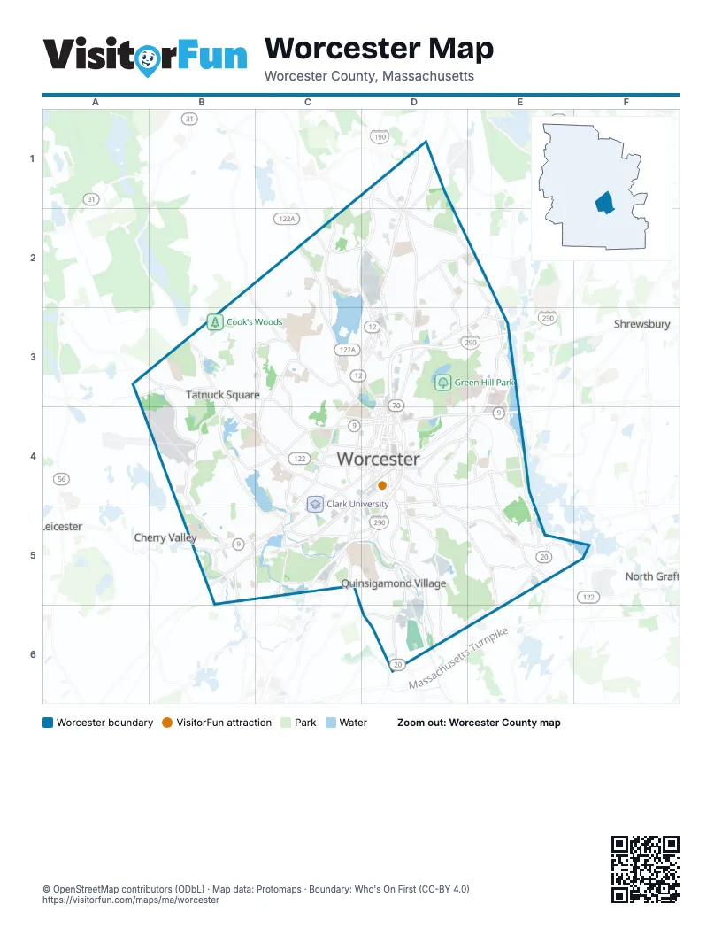
Street index of Worcester
Each street on the sheet and the grid squares it crosses.
- Burncoat StreetD1, D2, D3
- Hartwell StreetD1
- Malden StreetD1, D2
- Mountain Street WestD1, D2
- State RoadD1
- West Boylston StreetD1, D2, D3
- West Mountain StreetD1, D2
- Salisbury StreetB2, C3, D3, D4
- Ararat StreetC2, D2
- Brattle StreetC2
- Grove StreetC2, C3, D3, D4
- Holden StreetC2, C3
- Main StreetC2, C4, D4, B5, C5
- Shore DriveC2, D2
- Andover StreetD2
- Barber AvenueD2, D3
- Briar LaneD2
- Brooks StreetD2
- Clark StreetD2, E2
- Country Club BoulevardD2, D3
- Erie AvenueD2
- Gosnold StreetD2
- Mountain Street EastD2, E2
- Norton DriveD2, D3
- Saint Nicholas AvenueD2
- Tacoma StreetD2, E2
- Boylston StreetE2, E3
- Northeast CutoffE2
- Plantation StreetE2, E3, D4, E4, D5
- Bailey StreetA3, B3
- Marshall StreetA3
- Pleasant StreetA3, B3, C3, C4, D4
- Airport DriveB3, B4
- Chandler StreetB3, B4, C4, D4
- Mill StreetB3, B4, C4, C5
- Moreland StreetB3, C3
- Mower StreetB3
- Olean StreetB3
- Flagg StreetC3
- Forest StreetC3
- Gold Star BoulevardC3, D3
- May StreetC3, C4
- Park AvenueC3, C4, C5
- Richmond AvenueC3, C4
- Lancaster StreetD3, D4
- Lincoln StreetD3, E3, D4
- Melrose StreetD3
- Millbrook StreetD3
- Nancy Johnson WayD3
- Neponset StreetD3
- North Service RoadD3
- Randolph RoadD3
- Ruthven AvenueD3
- West Boylston DriveD3
- West Boylston TerraceD3
- Woodbury StreetD3
- Lake Avenue NorthE3, E4
- Natural History RoadE3
- Research DriveE3
- South RoadE3
- Goddard Memorial DriveB4, B5
- June StreetB4, C4
- Canterbury StreetC4, C5
- Elm StreetC4, D4
- Hammond StreetC4, C5
- Highland StreetC4, D4
- Institute RoadC4, D4
- Lovell StreetC4, C5
- Maywood StreetC4, C5
- Newton SquareC4
- Piedmont StreetC4
- Southbridge StreetC4, D4, C5
- West StreetC4
- Aldrich StreetD4
- Austin StreetD4
- Belmont StreetD4, E4
- Chestnut StreetD4
- Church StreetD4
- Concord StreetD4
- Dorchester StreetD4
- East Central StreetD4
- Faraday StreetD4
- Foster StreetD4
- Francis J. Mcgrath BoulevardD4
- Franklin StreetD4, E4
- Front StreetD4
- Goldsberry StreetD4
- Grafton StreetD4, D5, E5
- Green Island BoulevardD4
- Green StreetD4
- Hamilton StreetD4, E4
- Harding StreetD4, D5
- Harrison StreetD4
- Harvard StreetD4
- High StreetD4
- Irving StreetD4
- Kelley SquareD4
- Lamartine StreetD4
- Lincoln SquareD4
- Linden StreetD4
- Madison StreetD4
- Major Taylor BoulevardD4
- Maple StreetD4
- Martin Luther King Jr. BoulevardD4
- McGrath BoulevardD4
- Mercantile StreetD4
- Millbury StreetD4, D5, D6
- Morris SquareD4
- Mount Carmel WayD4
- Murray AvenueD4
- Myrtle StreetD4
- Prescott StreetD4
- Providence StreetD4, D5
- Quinsigamond AvenueD4, D5
- Salem StreetD4
- School StreetD4
- Shrewsbury StreetD4, E4
- Summer StreetD4
- Temple StreetD4
- Thomas StreetD4
- Tuckerman StreetD4
- Vernon StreetD4, D5
- Ward StreetD4
- Washington SquareD4
- Water StreetD4
- Winter StreetD4
- Bigelow Davis ParkwayE4
- Boston Worcester TurnpikeE4
- Commonwealth AvenueE4, E5
- Harrington WayE4
- Lake AvenueE4, E5
- Apricot StreetB5
- Curtis ParkwayB5
- Heard StreetB5, C5
- James StreetB5
- Ludlow StreetB5
- Pinehurst AvenueB5
- South Ludlow StreetB5
- Stafford StreetB5, C5
- Boyce StreetC5
- Cambridge StreetC5, D5
- Coes SquareC5
- College StreetC5
- Fremont StreetC5
- Hope AvenueC5
- McKeon RoadC5, D5
- Mill Street ConnectorC5
- Riverside StreetC5
- Webster StreetC5
- Arwick AvenueD5
- Ashmont AvenueD5
- Blackstone River RoadD5
- Canton StreetD5
- Endicott StreetD5
- Granite StreetD5, D6
- Greenwood StreetD5, D6
- Heywood StreetD5
- Massasoit RoadD5, E5, E6
- Olde Millbury StreetD5
- Purple Heart HighwayD5, D6
- Sunderland RoadD5, E5
- Tobias Bolland WayD5
- Winthrop StreetD5
- Blithewood AvenueE5
- Grafton RoadE5
- Jennings StreetE5
- Southwest CutoffE5, D6, E6
- Westborough StreetE5, F5
- Latti Farm RoadD6
- Upland StreetD6
- Washington StreetD6
- Worcester-Providence TurnpikeD6
- Millbury AvenueE6
Places on the map
- 175 James Street
- Absolute Machinery Corporation
- Amazon Distribution Center
- Assumption University
- Bancroft on the Commons
- Bancroft School
- Beaver Brook
- Beaver Brook Park
- Bell Hill Park
- Bell Pond
- Belmont Hill
- Bennett Field
- Blackstone Gateway Park
- Blackstone Industrial Park
- Blais Family Library
- Bnai Brith Cemetery
- Booth Apartments
- Botany Bay
- Bovenzi Conservation Area
- Bowditch and Dewey Library
- Broad Meadow Brook Wildlife Sanctuary
- Burncoat Branch Library
- Burncoat Middle & High School
- Burncoat Park
- Burncoat Park Pond
- Capozzoli Athletic Center
- Carlson Science Library
- Cascades East
- Cascades Park
- Center Mill Apartments
- Central Business District
- Chandler Hill
- Chandler Magnet School
- Christopher House
- Clark Street Community School
- Clark University
- Clark University Becker School of Design and Technology
- Coes Park
- Coes Pond
- Coes Pond Village Apartments
Next to Worcester
- Cherry Valley
- Leicester
- North Grafton
- Shrewsbury
© OpenStreetMap contributors (ODbL) · Map data: Protomaps · Boundary: Who's On First (CC-BY 4.0)