

Massachusetts map
Worcester County map
About 881,248 people live here (Census Bureau, 2024 estimate). The sheet's index lists 13 streets; Massachusetts Turnpike, Purple Heart Highway and Wilbur Cross Highway cross the most grid squares. Things to do inside the boundary: Icon Museum and Study Center, Johnny Appleseed Trail and Old Sturbridge Village.
Open the map (PDF, US Letter)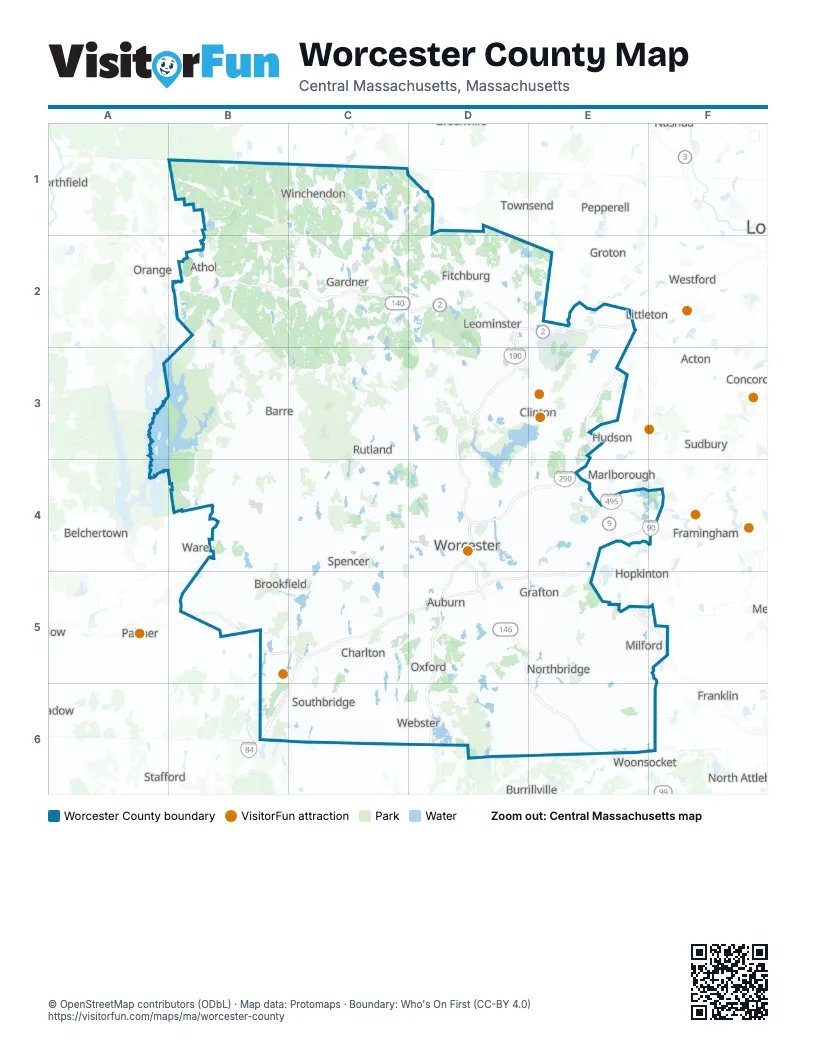
Maps inside Worcester County
1 map inside, from the street map of Worcester County down.
Street index of Worcester County
Each street on the sheet and the grid squares it crosses.
- Mohawk TrailB2
- State RoadB2
- George Stanton HighwayD2
- Concord TurnpikeE2
- Purple Heart HighwayD4, D5, E6
- Blue Star Memorial HighwayE4
- Massachusetts TurnpikeE4, B5, C5, D5, E5
- Wilbur Cross HighwayC5, B6, C6
- Worcester Providence RoadD5, E5, E6
- Worcester Providence TurnpikeD5, E5
- Worcester-Providence TurnpikeD5
- North Smithfield ExpresswayE6
- Providence PikeE6
Things to do on the Worcester County map
Places on the map
- 200 Sportsmen Club
- Adams Farm
- Afonso Estates
- Amadon-Willis Forest
- Anna Maria College Open Space
- Apple Hill Farm
- Ashburnham
- Ashburnham State Forest
- Asnacomet Pond
- Assabet River Reservoir
- Athol
- Athol Archery Club
- Auburn
- Auburn Sportman's Club
- Babbitt Wildlife Sanctuary
- Bacon-Morse Historic District
- Bailey Brook Conservation Area
- Baker Pond
- Balance Rock Farm
- Baldwin Hill Conservation Area
- Bare Hill Pond
- Barefoot Brook F.C.
- Barnum Industrial Park
- Barre
- Barre Falls Flood Control Area
- Barre Falls Project Area
- Barre Falls Wildlife Management Area
- Barre Landfill
- Barre Sportsmen's Club
- Barre State Forest
- Barrett Park
- Bartlett Pond
- Bartlett Swamp
- Bates
- Baylies Farm
- Bearsden Conservation Area
- Beaver Wetland
- Berlin
- Bickford Pond
Next to Worcester County
- Acton
- Ashland
- Belchertown
- Burrillville
- Concord
- Framingham
- Franklin
- Groton
- Hopkinton
- Hudson
- Littleton
- Marlborough
- Natick
- North Attleborough
- Northfield
- Orange
- Palmer
- Pepperell
- Stafford
- Sudbury
- Townsend
- Ware
- Westford
- Woonsocket
© OpenStreetMap contributors (ODbL) · Map data: Protomaps · Boundary: Who's On First (CC-BY 4.0)