

Maryland road map
I-695 in Maryland map
I-695 is a loop of about 48 miles in Maryland. It has 68 exits, from Exit 1 at mile 2 to Exit 44 at mile 47. It meets 37 highways; I-95, US 1 and US 40 meet it in the most grid squares.
Open the map (PDF, US Letter)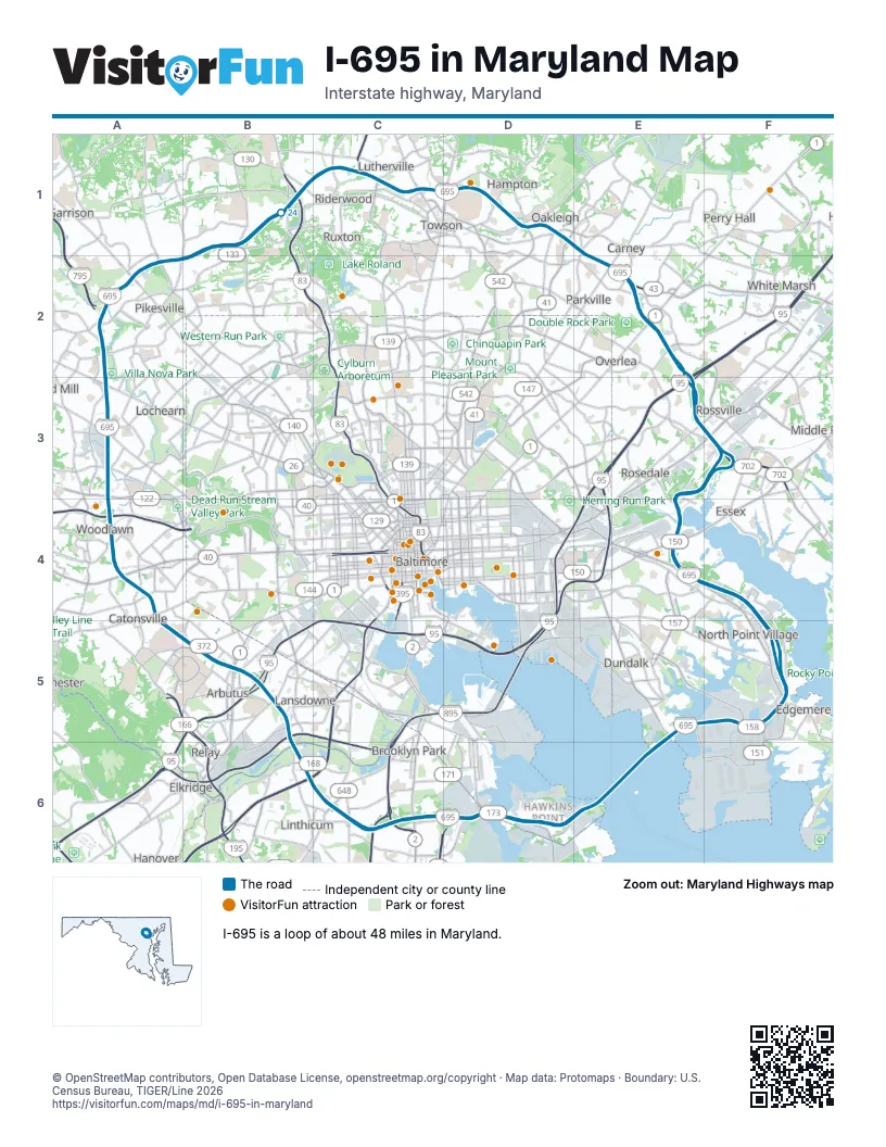
Exits on I-695 in Maryland
Each exit in mile order, with its grid square.
- Exit 1mile 2, D6
- Exit 3mile 3, D6
- Exit 2mile 4, C6
- Exit 3Amile 4, C6
- Exit 3Bmile 5, C6
- Exit 4mile 5, C6
- Exit 5mile 6, C6
- Exit 6Amile 6, C6
- Exit 6Bmile 7, C6
- Exit 7Bmile 7, C6
- Exit 7Amile 7, C6
- Exit 8mile 8, B6
- Exit 8Bmile 8, B6
- Exit 8Amile 8, B6
- Exit 9mile 8, B6
- Exit 10mile 9, B5
- Exit 11Amile 9, B5
- Exit 49Bmile 10, B5
- Exit 11Bmile 10, B5
- Exit 11A/11Bmile 10, B5
- Exit 12Amile 10, B5
- Exit 12B-Cmile 11, B5
- Exit 12C-Bmile 11, B5
- Exit 13mile 13, A4
- Exit 14mile 13, A4
- Exit 15Amile 14, A4
- Exit 15Bmile 14, A4
- Exit 16A-Bmile 14, A4
- Exit 16A/16Bmile 15, A4
- Exit 17mile 16, A3
- Exit 18A-Bmile 18, A2
- Exit 18mile 18, A2
- Exit 19mile 19, A2
- Exit 20mile 20, A2
- Exit 21mile 22, B1
- Exit 22mile 23, B1
- Exit 23Amile 24, B1
- Exit 23Bmile 25, B1
- Exit 23A-Bmile 25, B1
- Exit 24mile 26, C1
- Exit 25mile 27, C1
- Exit 26Amile 27, C1
- Exit 26Bmile 28, C1
- Exit 26mile 28, C1
- Exit 27Amile 28, C1
- Exit 27Bmile 28, C1
- Exit 28mile 29, D1
- Exit 29Amile 30, D1
- Exit 29B-Amile 30, D1
- Exit 29Bmile 30, D1
- Exit 30Amile 31, D1
- Exit 30Bmile 31, D1
- Exit 31A-Bmile 32, E2
- Exit 31Amile 32, E2
- Exit 31Bmile 33, E2
- Exit 31Cmile 33, E2
- Exit 32Amile 34, E2
- Exit 32Bmile 34, E2
- Exit 33mile 36, E3
- Exit 34mile 36, E3
- Exit 35Amile 37, F3
- Exit 35Bmile 37, F3
- Exit 36mile 37, F3
- Exit 38Amile 39, E4
- Exit 40mile 41, F4
- Exit 41mile 42, F5
- Exit 43mile 45, F5
- Exit 44mile 47, E6
Highways I-695 meets
Each highway it meets and the grid squares where they meet.
- MD 173D6
- MD 710D6
- MD 2C6
- I-895BC6
- I-895AC6
- I-97C6
- MD 648C6
- MD 170C6
- MD 295C6
- I-895B6
- MD 168B6
- I-95B5, E3
- US 1B5, E2
- MD 372B5
- MD 144A5
- US 40A4, F3
- I-70A4
- MD 122A4
- MD 26A2
- MD 140A2
- MD 129A2
- MD 25B1
- I-83B1
- MD 139C1
- MD 45C1
- MD 146C1
- MD 542D1
- MD 41D1
- MD 147E2
- MD 43E2
- MD 7F3
- MD 702F3
- MD 150E4
- MD 151F5
- MD 157F5
- MD 158F5
- MD 695E5
Towns along I-695 in Maryland
In mile order, with the grid square of each.
- Baltimoremile 0, E6
- Pasadenamile 0, E6
- Glen Burniemile 2, D6
- Brooklyn Parkmile 3, D6
- Ferndalemile 5, C6
- Linthicummile 6, C6
- Baltimore Highlandsmile 7, C6
- Lansdownemile 8, B6
- Arbutusmile 9, B5
- Catonsvillemile 11, B5
- Woodlawnmile 13, A4
- Milford Millmile 16, A3
- Lochearnmile 16, A3
- Randallstownmile 19, A2
- Pikesvillemile 20, A2
- Garrisonmile 20, A2
- Towsonmile 24, B1
- Mays Chapelmile 25, B1
- Timoniummile 26, C1
- Luthervillemile 27, C1
- Hamptonmile 28, C1
- Carneymile 30, D1
- Parkvillemile 31, D1
- Overleamile 33, E2
- White Marshmile 34, E2
- Rossvillemile 34, E2
- Rosedalemile 35, E2
- Middle Rivermile 37, F3
- Essexmile 37, F3
- Dundalkmile 39, E4
- Edgemeremile 43, F5
Things to do on the I-695 in Maryland map
© OpenStreetMap contributors, Open Database License, openstreetmap.org/copyright · Map data: Protomaps · Boundary: U.S. Census Bureau, TIGER/Line 2026















