

Maryland map
Salisbury map
About 33,616 people live here (Census Bureau, 2024 estimate). The sheet's index lists 300 streets; Beaglin Park Drive, Salisbury Bypass and North Salisbury Boulevard cross the most grid squares. Things to do inside the boundary: Salisbury Zoo and The Country House.
Open the map (PDF, US Letter)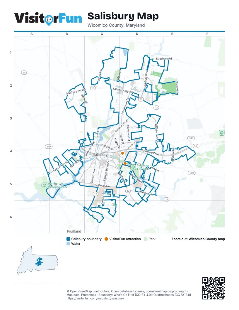
Street index of Salisbury
Each street on the sheet and the grid squares it crosses.
- Salisbury BypassB2, C2, D2, E4
- East Salisbury ParkwayC4, D4, E4
- North Salisbury BoulevardD2, C3, D3, C4
- South Salisbury BoulevardC4, C5, C6
- Snow Hill RoadC4, C5, D5, D6
- East Main StreetC4, D4
- West Salisbury ParkwayB4, C4
- Ocean GatewayB4, E4
- East Ruark DriveD2
- Ward StreetC4
- Beaglin Park DriveD3, E3, D4, E4, D5
- West Naylor Mill RoadB2, C2, D2
- Mount Hermon RoadD4, E4
- East Naylor Mill RoadD2, D3
- West College AvenueB5, C5
- East College AvenueC5, D5
- Old Ocean City RoadD4, E4
- Mill StreetC4
- East Carroll StreetC4
- West Carroll StreetC4
- Nanticoke RoadB4
- Zion RoadD3
- Northwood DriveD2, D3
- South Division StreetC4, C5, C6
- South Park DriveC4, D4, D5
- Riverside DriveC4, B5, C5
- Camden AvenueC4, C5
- East Church StreetC4, D4
- Lake StreetC3, C4
- North Division StreetC3, C4
- Pemberton DriveB4, A5, B5
- Eastern Shore DriveC4, C5
- East Isabella StreetC4, D4
- West Main StreetB4, C4
- West Isabella StreetB4, C4
- Glen AvenueC4, D4, D5
- Johnson RoadD5, E5
- Naylor StreetC4, D4
- Tilghman RoadE4
- Waverly DriveC4, C5
- North Schumaker DriveD5
- Middleneck DriveD3
- Phillip Morris DriveE4
- Civic AvenueD4
- East Vine StreetC4, C5
- South Schumaker DriveC5, D5
- Church StreetC4
- Armstrong ParkwayD2
- Merritt Mill RoadE4
- Parsons RoadB4
- Jersey RoadC2
- Hobbs RoadE4, F4
- West Vine StreetC4
- Fitzwater StreetB4, C4
- Kiley DriveD2
- Goddard ParkwayC2, D2
- Moss Hill LaneD3, D4
- Dagsboro RoadD1, E1
- Long AvenueD4
- Broad StreetC4
- Centre RoadD2
- Baptist StreetC4
- Small StreetC4
- Centre DriveD2, D3
- Mill Pond LaneD2, E2
- Delaware AvenueC3, C4
- North Park DriveC4, D4, D5
- West RoadB2, C3, C4
- Priscilla StreetD3, D4
- Harbor Point DriveB5
- South BoulevardC5
- Marvel RoadC2, D2
- Progress CircleD5
- Emerson AvenueC3
- Truitt StreetC3, D3, D4
- Roger StreetC5
- Hammond StreetD3, D4
- Smith StreetC4, C5
- East William StreetC4, D4
- East Lincoln AvenueC5, D5
- Spring AvenueC5
- Jefferson StreetD3, D4
- Monticello AvenueB5, C5
- Onley RoadC5
- West Zion RoadD2
- Brown RoadE2
- Dykes RoadC6
- Brown StreetD3, C4, D4
- Washington StreetC4, C5
- Handys MeadowsB5
- Foxfield DriveD3
- Pinehurst AvenueC5
- Woodbrooke DriveE4
- Windsor DriveD2, D3
- Marley Manor DriveD5
- Decatur AvenueD3, D4
- Scenic DriveC2
- Schumaker LaneD5
- Wayne StreetC5, C6
- Marquis AvenueB3
- Dover StreetD3, D4
- Still Meadow BoulevardD3, E3
- East North Pointe DriveD1, E2
- Bell Island TrailB5
- Prince StreetC5
- Shipley DriveD2, D3
- Saint Albans DriveD4
- Hampshire RoadD1, D2
- Canal Park DriveC6
- Edgewater DriveD5
- Paleo LaneC2
- Parsons Lake DriveD2, E2
- North Pinehurst AvenueB5, C5
- Westwood DriveB2, B3
- Liberty StreetD3, D4
- Milford StreetC6
- Poplar Hill AvenueC4
- Spring Crest DriveC6
- Industrial ParkwayC2, C3
- Dallas DriveE4
- Cypress StreetC4
- Riverside RoadB5, C5
- Shiloh StreetC5, D5
- Alley 1C4, D4
- Russell AvenueC5
- Tarry Town RoadA4
- Rose StreetC4
- Village Oak driveC6
- East Railroad AvenueC4
- Booth StreetC3, C4
- Robins AvenueD5
- Elizabeth StreetC4
- Davis StreetC4, D4
- Winterborn LaneC6
- Aspen DriveC6
- Anchors WayB5
- Princeton AvenueC5
- Dickerson LaneD1
- Darwin DriveD3
- Ramsey CourtD5
- Village CourtB4, D4
- Roland StreetC4, C5
- Northgate DriveD2
- Oak Hill AvenueC4, C5
- Catherine StreetC4
- Fairview LaneB4
- Cedar CrossingC5
- Johnson StreetC3, D3
- Marine RoadB4, B5
- Culver RoadB4
- South Tower DriveC5
- Ridge RoadB5, C5
- Newton StreetC4
- Winder StreetC4, C5
- Viewfield DriveD4, E4
- Beaver Dam DriveD4
- Hemlock StreetC5, D5
- Jackson StreetC4, C5
- West London AvenueC3, C4
- Druid Hill AvenueB5, C5
- Marquis DriveB3
- Park AvenueC4
- Cross Creek DriveA4, B5
- Buena Vista AvenueC4
- Farmers Market RoadC6
- Stone Gate DriveD5
- Harford RoadD2, D3
- Hillcrest AvenueD3
- Parkwood DriveC6
- Madison StreetC4, C5
- Union AvenueC3, C4
- Wintermead LoopB4
- North Khione LoopD5, D6
- Kestrel DriveD5
- Ballinadee DriveC6
- New York AvenueC4
- Maryland AvenueC4, C5
- Wicomico StreetC4
- Adams AvenueC5
- Bryn Mawr AvenueD3
- Ohio AvenueC5
- Brittingham StreetD3
- Spruce StreetC5
- Granbys RunD5, E5
- East Market StreetC4
- University TerraceC6
- Hazel AvenueC5
- Bateman StreetC5
- Carrollton AvenueC5
- North BoulevardC5
- Pryor AvenueC5
- Alabama AvenueC4, C5
- Bell Creek DriveA4, A5
- South Saratoga StreetD4
- West Schumaker Manor DriveD5
- Lakeside DriveC4
- Fairground DriveB4
- Arlington RoadD3
- Bethel StreetC5
- Clay StreetD4
- Overlook DriveD2, E2
- Pennsylvania AvenueC5
- Homer StreetD3
- Green Mor AvenueC5
- Troopers WayD1, E1
- Treetop DriveC6
- Honeysuckle DriveC6
- West Market StreetC4
- Grace StreetC4, D4
- Hannibal StreetD5
- Riverhouse DriveB4
- Mitchell RoadB4, C4
- Caravan WayD5
- Sharen DriveE4
- Whitter DriveC3
- Sumac CircleD5
- Deborah DriveD3
- East Locust StreetC4
- Oak StreetC4
- Calvert StreetC4
- Beam StreetC3, D3
- Brooklyn AvenueC3, C4
- East Schumaker Manor DriveD5
- Ellegood StreetB4
- Westchester StreetC3
- Evergreen AvenueB5
- Forest LaneC5
- Terrapin LaneD5
- Alvin AvenueD4
- West Railroad AvenueC4
- Chippewa BoulevardB3, C3
- White StreetD4
- Circle AvenueC4
- South PinehurstB5, C5
- Somerset AvenueC5
- Perry DriveC5
- West North Pointe DriveD1
- Winding WayD5
- Cotton Patch IslandB5
- 2nd StreetC4
- South Clairmont DriveC5
- Autumn Grove CourtE4
- Beckford CourtC6
- North Clairmont DriveC5
- Oliphant DriveD1
- Sleepy Hollow DriveB5
- Schumaker Woods RoadD5
- Baker StreetC4
- Tyler AvenueC5, D5
- Walston AvenueD4
- 1st StreetC4
- Virginia AvenueC5
- Preston StreetD4
- Park Heights AvenueC4
- Marshal StreetC4, D4
- West Philadelphia AvenueC4
- Holland AvenueD4
- Martin StreetC4
- Benny StreetC4, D4
- Tressler DriveA5, B5
- Fire Fly DriveA4, B4, B5
- Springfield CircleC5
- Midland TerraceD4, E4
- Stream Valley CourtD3, E3
- Richwil DriveC4, D4
- Oakdale RoadC4
- South Haven AvenueC5
- Waverly StreetC4, C5
- Barclay StreetC4
- Edgemore AvenueC3, D3
- Columbia DriveD3
- Jasmine DriveD1, D2
- Meadow Point RoadB5
- Sandy Bottom CourtC6
- Hanover StreetC5
- West Gordy RoadD3
- New Bedford WayD5, E5
- Race StreetC4
- Sheffield AvenueC4
- Coles CircleD4
- Deer's Head Hospital RoadC3
- Georgia AvenueC5
- Middle BoulevardC5
- Brookridge DriveD3
- Cottontail DriveD5
- Vaden AvenueD3
- Emory CourtD4, D5
- Lloyd StreetC5
- College LaneD5
- Heron CourtD5
- Monroe StreetC4, C5
- Parkway AvenueD4
- Powell AvenueC5
- Misty Hollow DriveE2
- Wailes StreetC4
- Pearl StreetC4
- Christiansen LaneC5
- James CourtD5
- Turnstone CircleD5
- Avery StreetC5
Things to do on the Salisbury map
Places on the map
- 7-Eleven
- Acme
- Addison Court Dog Park
- Canal Walk Park
- Delmarva Light & Power
- Encompass Health Rehab Hospital Of Salisbury
- Government Office Building
- Green Acres Memorial Park
- Henry S. Parker Athletic Complex
- Indoor Tennis Center
- Lord Salisbury Center
- Mitchell Pond #2
- Mitchell Pond #3
- North Pointe Plaza
- North Prong Wicomico River
- Parkside High School
- Parsons Cemetery
- Parsons Lake
- Pemberton Little League Park
- Pemberton School
- Peninsula Regional Medical Center
- Pinehurst School
- Prince Street School
- Route 13 Post Office
- Salisbury City Park
- Salisbury Marina
- Salisbury Park Picnic Area
- Salisbury Plaza
- Salisbury Post Office
- Salisbury Riverbank
- Salisbury Zoo
- Shoppes at Salisbury
- South Prong Wicomico River
- The Centre at Salisbury
- The Commons
- Tonytank Pond
- Walmart Supercenter
- Wicomico Junior High School
Next to Salisbury
- Fruitland
© OpenStreetMap contributors, Open Database License, openstreetmap.org/copyright · Map data: Protomaps · Boundary: Who's On First (CC-BY 4.0); Quattroshapes (CC BY 2.0)















