

Maryland map
Eastern Shore map
The sheet's index lists 21 highways; US 50, US 113 and US 301 cross the most grid squares. Things to do inside the boundary: Academy Art Museum, Assateague Island National Seashore and Baja Amusements. Also on it: Cambridge, Centreville and Chestertown.
Open the map (PDF, US Letter)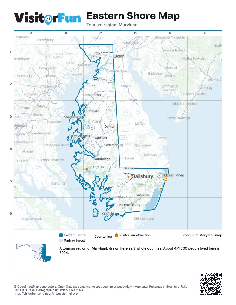
Highway index of Eastern Shore
Each highway on the sheet and the grid squares it crosses.
- I-95C1
- US 1C1
- US 13D5, D6
- US 40C1
- US 50B3, C3, C4, C5, D5, E5
- US 113D5, D6, E5
- US 222C1
- US 301B3, C2, C3
- DE 1E5
- MD 16C3, C4
- MD 90D5, E5
- MD 222C1
- MD 279C1
- MD 300C2
- MD 302C3
- MD 305C3
- MD 313C2, C3
- MD 404C3, C4
- MD 454C3
- MD 528E5
- MD 544C2
Things to do on the Eastern Shore map
- Academy Art Museum
- Assateague Island National Seashore
- Baja Amusements
- Bay Country Antiques
- Bayside Boat Rentals
- Blackwater National Wildlife Refuge
- Calvin B. Taylor House Museum
- Chesapeake Bay Maritime Museum
- Harriet Tubman Underground Railroad National Historical Park
- Janes Island State Park
- Jolly Roger Amusement Park
- Lost Treasure Golf - Ocean City
- Miss Ocean City
- OC Downtown Adventures
- OC Parasail
- Ocean City Boardwalk
- Ocean City Visitor Center
- Ocean Lanes Bowling Center
- Outlets Ocean City
- Plumpton Park Zoo
- ProTrack
- Rackliffe House
- Ripley's Believe It Or Not Ocean City
- Salisbury Zoo
- The Bonfire Restaurant
- The Country House
- Tortuga Bay Fishing
- Trimper's Rides
- Wye Oak State Park
Places on the map
- Cambridge
- Centreville
- Chestertown
- Crisfield
- Delmar
- Denton
- Easton
- Elkton
- Federalsburg
- Ocean Pines
- Pocomoke City
- Saint Michaels
- Salisbury
- Snow Hill
- Stevensville
Next to Eastern Shore
- Central Delaware
- Northern Delaware
- Southern Delaware
- Central Maryland map
- Dutch Country Roads
- Philadelphia and the Countryside
- Coastal Virginia - Eastern Shore
© OpenStreetMap contributors, Open Database License, openstreetmap.org/copyright · Map data: Protomaps · Boundary: U.S. Census Bureau, Cartographic Boundary Files 2024