

Maine map
Auburn map
About 25,200 people live here (Census Bureau, 2024 estimate). The sheet's index lists 300 streets; Minot Avenue, Riverside Drive and Hotel Road cross the most grid squares. Also on it: Gulf Island Pond, Lake Auburn and Lost Valley Ski Area.
Open the map (PDF, US Letter)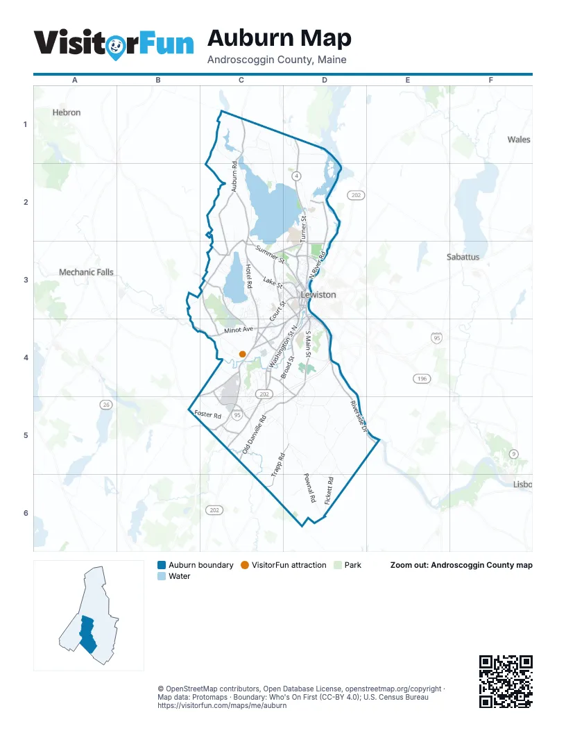
Street index of Auburn
Each street on the sheet and the grid squares it crosses.
- Maine TurnpikeC4, D4, C5
- Minot AvenueD3, B4, C4, D4
- Turner StreetD2, D3
- Washington StreetD3, D4, C5
- Center StreetD2, D3
- Washington Street NorthC4, D4, C5
- South Main StreetD3, D4
- Turner RoadD1, D2
- Broad StreetD3, C4, D4
- Washington Street SouthC4, D4, C5
- Mount Auburn AvenueC3, D3
- Court StreetC3, D3, C4
- Mill StreetD3, D4
- Union Street BypassD3
- Main StreetD3
- High StreetD3
- Academy StreetD3
- Russell StreetD3
- Cedar StreetD3
- Riverside DriveD3, D4, D5, E5
- Summer StreetC2, C3, D3
- Poland Spring RoadC5
- Youngs Corner RoadC2, C3
- Manley RoadC4
- Jackson Hill RoadC3
- Elm StreetD3
- Joline DriveD3
- Mechanics RowD3
- Ricker RoadC5
- Hotel RoadC2, C3, C4, C5
- Perkins Ridge RoadC2, C3
- North River RoadD2, D3
- Old Danville RoadD4, C5, D5
- Garfield RoadC3, C4
- Lake StreetC3, D3
- Trapp RoadC5, D5, C6
- Park AvenueC3
- West Auburn RoadC2
- Kittyhawk AvenueC4, C5
- Lewiston Junction RoadC4
- Hatch RoadC3, C4
- Poland RoadC4, D4
- North Auburn RoadC1, C2
- Skillings Corner RoadC1
- Hackett RoadC4, D4
- Rodman RoadC4
- Gamage AvenueC3, D3
- Gracelawn RoadC3, D3
- Western AvenueD3
- Stetson RoadD3
- Spring StreetD3
- Hampshire StreetD3
- Chasse StreetC4
- Goff StreetD3
- Dennison StreetD3
- Great Falls PlazaD3
- Philomar StreetC4
- Miami AvenueC4
- East Garfield RoadC3
- Pownal RoadD4, D5, D6
- Jordan School RoadD5, D6
- Sopers Mill RoadD5, D6
- Lake Shore DriveC1, C2, D2
- Whitman Spring RoadC1, C2
- South Witham RoadD4, D5
- Stevens Mill RoadC3, C4
- Fickett RoadD5, D6
- Beech Hill RoadC4, C5
- Danville Corner RoadC5, D5
- Foster RoadB5, C5
- Fletcher RoadC4
- Johnson RoadC1
- Maple Hill RoadC1, C2
- Merrow RoadC4
- Harmons Corner RoadD5
- East Waterman RoadD1
- Holbrook RoadC1
- Penley Corner RoadD4, D5
- East Hardscrabble RoadC4, C5
- Hersey Hill RoadC1
- Witham RoadD4
- Oak Hill RoadD2
- Butler Hill RoadB3, C3
- Browns Crossing RoadC5
- Townsend Brook RoadD1
- Cook StreetD3, D4
- Fairway DriveC4
- Eastman LaneC5
- Woodbury RoadC5
- Steele RoadD5
- Turkey LaneC5
- Vickery RoadD4
- Hobart RoadD5, D6
- Pumping Station RoadD2
- Dillingham Hill RoadC1
- Andrew DriveD2
- West Hardscrabble RoadC4
- Brighton Hill RoadC2
- Cascades DriveC4, C5
- Lost Valley RoadC2, C3
- First Flight DriveC5
- Black Cat RoadC5
- Hickory DriveC4
- Royal River RoadC5
- Lake Auburn AvenueD3
- Bark Mulch DriveC4
- West Shore RoadC3
- Bradman StreetD3
- Beaver RoadC1
- Third StreetD3, D4
- Sixth StreetD3, D4
- Fairview AvenueC3, D4
- Fifth StreetD3, D4
- Nottingham RoadC3
- Whitney StreetD3
- Winter StreetD3
- Yacht Club DriveC3
- Davis AvenueC3, D3
- Chicoine AvenueC3
- Garden CircleC5
- Stone RoadD1
- East Shore RoadC3
- Valview DriveC3
- Field AvenueC3, D3
- Seventh StreetD4
- Lane RoadD4
- Station RoadC5
- Allied RoadC5
- Pride RoadC4
- Flight Line DriveC4, C5
- F StreetC3
- Broadview AvenueD3
- Highland AvenueD3
- Hatfield RoadC2
- Morin Brick RoadC5
- Deer Rips Dam RoadD2
- Marston Hill RoadC2
- Blanchard RoadD2
- Pettingill ParkD3
- Granite StreetC3, D3
- Allen AvenueC3
- Bennett AvenueD4
- Martindale RoadC4
- Wyman RoadC3
- Pleasant StreetD3
- Northern AvenueD3
- Fern StreetC3, D3
- Second StreetD3, D4
- Harvard StreetD3
- Jacques RoadD5
- Elmwood RoadD2
- Cleve RoadD6
- Ledgeview CoveC3
- Chickadee DriveD1
- Baxter AvenueC4, D4
- Pond View DriveC3
- Loring AvenueD4
- Everett RoadC3
- Howe StreetC3
- Gill StreetD4
- Gracelawn Pit RoadC3
- Joatmon DriveD4
- Old Portland RoadC5
- Poliquin AvenueC4
- Cedarwood RoadC3
- Sunderland RoadC3, C4
- Lunn RoadC1
- Grandview AvenueC3
- Fish Hatchery RoadD2
- Madison StreetD3, D4
- Mystique WayC4
- I StreetC3
- Shepley StreetD3
- C StreetC3
- Mountain View DriveC5
- Colonial WayC3
- Kyle LaneD4, D5
- Ninth StreetD4
- Boulder DriveC3
- Country Club DriveC4
- Harris StreetD3
- Hillcrest StreetD3
- Orchard StreetC3, D3
- Bailey RoadC1
- Sunderland DriveC3
- Vista DriveC3
- Willard RoadC3
- Newbury StreetD3
- Jennifer DriveC4, C5
- Western PromenadeD3
- Taft AvenueC4, D4
- Old Farm HillD3, D4
- Sturkes RoadC1
- Fourth StreetD4
- Terrace RoadC3
- Twin RoadC4
- Pionite RoadC4
- East Bates StreetD3
- Eighth StreetD4
- Bretton AvenueC4
- Sunrise LaneC3
- Glendale AvenueC4
- Harvest Hill LaneC5
- Paul StreetD4
- Brentwood DriveC4
- David's DriveC4
- Kassborhrer WayC4
- Omni CircleC4
- Coburn StreetD3
- Monroe StreetD3, D4
- Maple PointC4
- Locksley RoadC3
- Pinnacle DriveC3, D3
- Outlook DriveD5
- Cherry Vale CircleC4
- Drummond StreetD3
- Clover LaneC3
- Hillside AvenueD3
- Cleveland AvenueD3, D4
- Danville Junction RoadC5
- Pinewood DriveC3
- Logistics DriveC5
- Louise StreetD4
- Richardson StreetC4
- Belgrade AvenueC4
- Par Four DriveC4
- Aquamarine CourtC3
- Partridge LaneD5
- Small RoadC3
- Sherwood DriveD4
- Quail RunC2
- Danbury DriveC5
- Woodlawn AvenueC3
- Dunn StreetD3, D4
- Portland WayC5
- Roak StreetD4
- Stevens Mill Park RoadC3, C4
- Dawes AvenueC3
- Mary Carroll StreetD4
- Marshall AvenueD3, C4
- Conant AvenueC3, D3
- West Dartmouth StreetD3
- Huard AvenueC4
- Sunset AvenueC3
- Aviation AvenueC4
- Coachman AvenueC3, D3
- Goldthwaite RoadC4
- Cove RoadC3
- Summit StreetD3
- Alderwood RoadC3
- Russell AvenueD3
- Tourmaline LaneC3
- Lubear WayD4
- Amberley WayC3
- Tournament DriveD5
- Musket DriveC5
- Old Carriage RoadC3
- James StreetD3
- Foch StreetC4
- Briarcliff KnollC3
- Brickyard CircleD4
- West Bates StreetD3
- Wright's Landing RoadC4
- Holly StreetD3
- Joffre StreetC4
- Kings RoadD3
- Littlefield RoadC4
- Hemlock CircleC3
- Gammon AvenueD3
- Houghton StreetC3, C4
- Gillander AvenueC3
- Lucille StreetD4
- Caron LaneD4
- Blackmer StreetD3
- Olive StreetD4
- 7th StreetD4
- Bolster StreetD4
- Roy AvenueD4
- Dana AvenueD3
- Oakland StreetD3
- Church StreetD2
- Evergreen RoadC3, D3
- Spencer DriveC5
- Troy StreetD3
- Webster StreetD3
- Braman StreetD3
- Hillsdale StreetC3, D3
- Towle AvenueC4
- Bowdoin StreetD3
- Charter WayC4, C5
- Hazel StreetD3
- Waterview DriveC3
- Northern Avenue HeightsD3
- Newell AvenueD3
- Marston StreetC3, C4
- Bobbin Mill DriveD2
- Presidential WayC5
- Constellation DriveC4
- Meadow LaneC3
- Millbrook LaneC4
Places on the map
- Auburn Mall
- Auburn Middle School
- Auburn Plaza
- Auburn Post Office
- Auburn-Lewiston Municipal Airport
- Based Aircraft Apron
- Butler Hill
- Chestnut Street Park
- Christian Hill
- Cliff Rydholm Park
- Clover Manor
- Dillingham Hill
- East Auburn Community School
- Edward Little High School
- Fairview School
- Gracelawn Memorial Park
- Gulf Island Pond
- Lake Auburn
- Lakeview Fields
- Laurel Hill
- LAYSA Field Complex
- Lost Valley Ski Area
- Lowe's
- Marstons Hill
- Martindale Country Club
- Merrill Hill
- Mount Apatite
- Mount Apatite Park
- Mount Auburn Cemetery
- Mount Auburn Plaza
- National Guard Auburn Training Site
- Pettingill Park
- Pope Conservation Area
- Ricker's Field Loop
- Saint Dominic Academy
- Shaw's Plaza
- Taylor Pond
- The Basin
- Whitholm Farm Plaza
Next to Auburn
- Hebron
- Lewiston map
- Lisbon
- Mechanic Falls
- Sabattus
- Wales
© OpenStreetMap contributors, Open Database License, openstreetmap.org/copyright · Map data: Protomaps · Boundary: Who's On First (CC-BY 4.0); U.S. Census Bureau















