

Maine map
Biddeford map
About 22,370 people live here (Census Bureau, 2024 estimate). The sheet's index lists 300 streets; Pool Street, West Street and South Street cross the most grid squares. Also on it: Biddeford Municipal, Back Bay and Biddeford Forest.
Open the map (PDF, US Letter)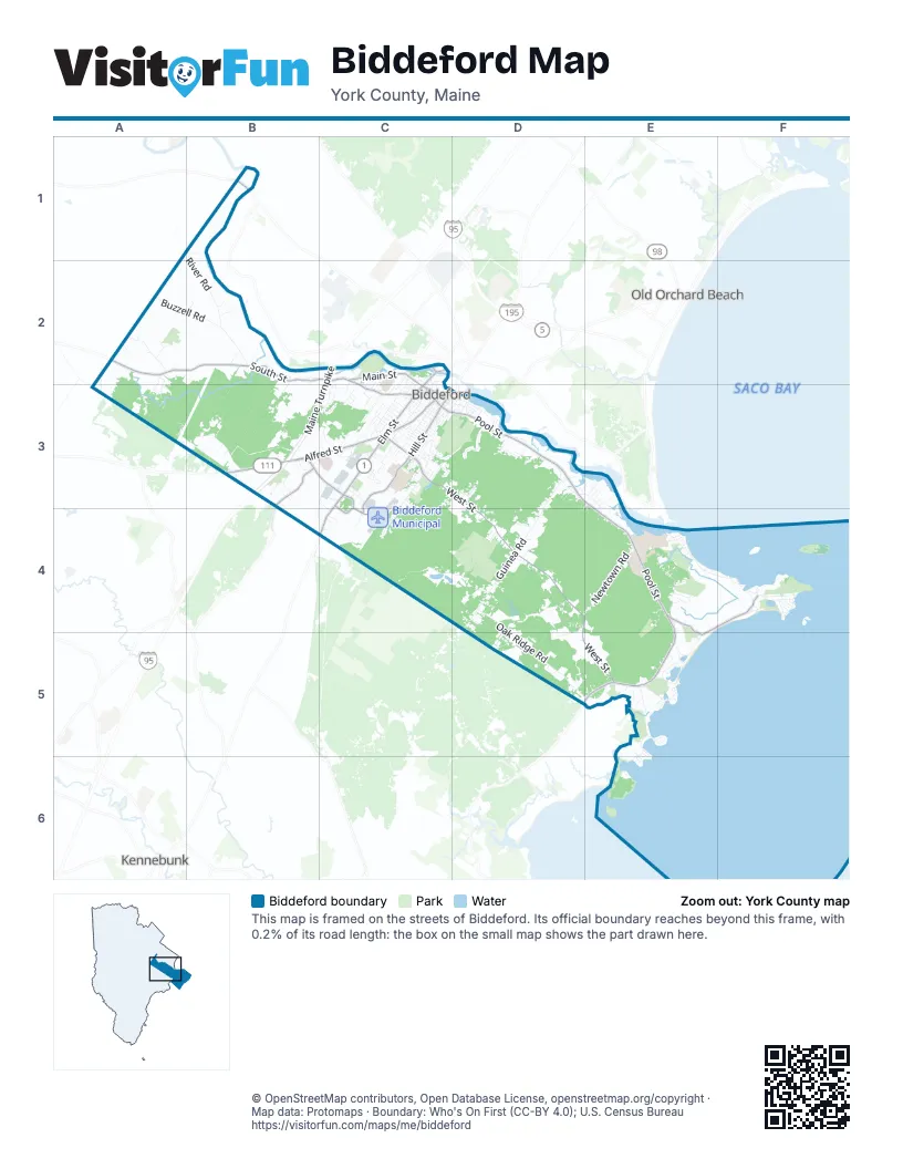
Street index of Biddeford
Each street on the sheet and the grid squares it crosses.
- Maine TurnpikeC2, B3, C3
- Alfred StreetB3, C3
- Elm StreetC2, C3, C4
- Main StreetC2, C3, D3
- Precourt StreetB3, C3, C4
- Pool StreetC3, D3, E3, E4, D5, E5
- Bridge RoadE4, E5
- New County RoadB1
- West StreetC3, D3, D4, E4, D5, E5
- South StreetA2, B2, C2, C3
- Hill StreetC3, C4
- Mile Stretch RoadE4, F4, E5
- Mountain RoadB3
- Landry StreetC3, C4
- Jefferson StreetC3
- Pine StreetC2
- Carver StreetC3
- Guinea RoadD3, D4
- Oak Ridge RoadD4, D5, E5
- Granite StreetC3, C4
- Hills Beach RoadE4, F4
- River RoadB1, B2
- Fortunes Rocks RoadE5
- Granite Point RoadE5, E6
- Newtown RoadD4, E4
- Old Pool RoadE4
- Buzzell RoadA2, B2
- Andrews RoadB3
- Proctor RoadC4, D4
- Wadlin RoadA2
- Graham StreetC3
- May StreetC3
- Lester B Orcutt BoulevardF4
- Prospect StreetC3
- Parkside DriveD3
- Morin StreetB3, C3, B4, C4
- Meeting House RoadD3
- Cathedral Oaks DriveC2, C3
- Forest StreetC3
- Barra RoadC3
- Edwards AvenueC3
- Cole RoadC3
- Ocean AvenueF4
- Westmore AvenueC3
- Cleaves StreetD3
- Sevigny AvenueD3
- Sokokis RoadD3, E3, E4
- Seaspray DriveE5
- Western AvenueC2, C3
- Summer StreetC3
- Benson RoadD4
- Peter Pond LaneE5
- Smithfield LaneD4, D5
- Maddox Pond RoadE5
- Scadlock Mill RoadE5
- Westwood DriveD3
- Foss StreetC3
- Green StreetC3
- Harold AvenueC3
- Wildbrook DriveD4
- Apple Ridge DriveA2
- First StreetF4
- Greenfield LaneC3
- Elizabeth RoadE5
- Village LaneC2, C3
- Birch StreetC3
- Boulder WayB3
- Fox Farm RoadD5
- Grayson StreetC3
- Jessie LaneB3
- Marion AvenueC3
- Bradbury StreetC2, C3
- Maplewood AvenueC2, C3
- Raymond StreetC3
- Whitewater DriveB2
- Timber Point RoadE6
- Dennett RoadA2, A3
- Saint Martins LaneF4
- Decary RoadD3
- Waterworks DriveB2, B3
- Ocean View DriveE4
- Pomerleau StreetC3
- Duffys WayE4
- Channel Cove LaneE4
- Paquin AvenueC3
- Biddeford Gateway CenterB3
- Old Hollis RoadB2, C2
- Tiger DriveC3
- Bayberry RoadE5, E6
- Clifford StreetD3
- Mariner WayB3
- McKenney DriveC3
- Ledgemere DriveD3
- Blandings WayD3
- Mason StreetC3
- Indian Ridge DriveC3
- Thatcher Brook LaneC3
- Rockwood DriveD4
- Alexander DriveC3
- Bakers WayC3
- Sky Oaks DriveD4
- Bernard AvenueC3
- Prince Phillip DriveA2, A3
- Ridgeview DriveC3
- Wentworth StreetC3
- Highland StreetC2, C3
- Seventh StreetF4
- Ferry LaneE3
- West Loop RoadD3, D4
- Cranberry LaneD4
- Twin Island DriveE3
- Mount Pleasant StreetC2, C3
- Round Hill StreetC3
- Dandelion WayD5
- Arrowwood DriveC3
- Ice House RoadE5
- Days LandingE4
- Shore RoadE5
- Pearl StreetC2
- Waco DriveC3
- High StreetC3, D3
- Pike StreetC3, D3
- Wesley DriveD4
- Evanthia DriveD4
- Oak StreetC3
- Crestwood DriveD3, E3
- Grenier AvenueD4
- Robin CircleC3
- Lindale AvenueC3
- Fourth AvenueF4
- Little House of Prayer DriveB2
- Lady Jennifer DriveA2, A3
- Union StreetC3
- Digital DriveC4
- Marial AvenueD3
- Washington StreetC3
- Country DriveB2
- Bacon StreetC3
- Kennedy DriveC3
- Glaude AvenueC3
- Autumn LaneB3
- Little River RoadE5
- Drapeau StreetC3, C4
- State StreetC2, C3
- Marblehead LaneD3
- Alison AvenueC3
- Libby DriveD3
- Plymouth DriveC3
- Ponderosa LaneC3
- Folsom DriveD4
- Old Dogs LaneB3
- Arctic CircleC3
- Nor'easter WayE4
- Medical Center DriveB3, C3
- Sky Harbor DriveF4
- Hayfield RoadB2
- Hedley Reynolds WayE4
- Harding StreetC3
- George StreetD3
- Orchard StreetC3
- Garden DriveB1
- Southgate AvenueC3
- Lamothe AvenueC3
- Murch RoadA1, B2
- Upper Falls RoadC2
- Lincoln StreetC2, C3
- Commodore DriveC4
- Memorial DriveC3
- Westland AvenueC3
- Parkview CourtC2
- Crickett LaneA2, B2
- Lessard AvenueC3
- Sullivan StreetC3, D3
- Lafayette StreetD3
- Breton StreetC3
- Marcel AvenueC4
- Amherst StreetC3
- Dartmouth StreetC3
- Third StreetF4
- Beacon AvenueC3
- Labbe LaneA2
- Ray StreetC3
- Taylor StreetC3
- Atlantic AvenueC3
- Yates StreetF4
- Shops WayB3
- Gertrude AvenueC3
- Adams StreetC3
- Vine StreetC3
- Dannys WayD3
- Roberts StreetC3
- Clearview DriveB3, B4
- Saco Falls WayC2, C3
- Miller AvenueD3
- Woodland DriveC3
- Quimby StreetC3
- Briarwood DriveC3
- Eighth StreetF4
- Twisted Oaks LaneD3
- Hillside AvenueC3
- Georgetown DriveD4
- Myrtle StreetC3
- Hallczuk RoadB3
- Dube LaneE3
- Tide Water DriveE3
- Saint Marys StreetC2
- Deer Run DriveC3
- Winding Creek LaneC3
- Chicopee LaneC2, C3
- Long Board LaneE5
- Beach House LaneF4
- Cutts StreetC2, C3
- Fieldcrest DriveD4
- Seal LaneE5
- Harvey StreetC2
- Wilson StreetC3
- Grays LaneC3
- Birchwood LaneC3
- Chretien RoadD4
- Dupont AvenueC3
- Brown Farm RoadB2
- Regina DriveD5
- Westfield StreetC3
- Simard AvenueD3
- Shepherds WayA2
- Clarendon StreetC3
- Dearborn AvenueC2, C3
- Wendell AvenueC3
- Parker Ridge RoadC3
- Marshall AvenueC3
- Harrison AvenueC3
- Lily Pond AvenueE5
- Orin LaneE4
- Pinewood CircleC3
- Easy StreetB3
- Old Kings HighwayE5
- Healthcare DriveB3, C3
- Town Line DriveA1, A2
- Saint Peters AvenueC3
- Stone Cliff RoadF4
- Thorndike AvenueE5
- Wellspring RoadC3
- Little Creek DriveD4
- Enterprise DriveC3
- Sapphire DriveD4
- Horrigan CourtC2
- West Cutts StreetC2
- Mount Vernon StreetC3
- Romeo LaneD3, D4
- Commercial StreetC4
- West Cole RoadC3
- Willett StreetC3
- Piersons LaneC3, D3
- Rebecca DriveD4
- Crescent StreetC3
- Charles AvenueC3, C4
- Prospect ManorC3
- Acorn StreetC3
- Hutchins DriveD5
- Water StreetD3
- Center StreetC3
- East Brook LaneC3
- Fox Hollow DriveB2
- Berry LaneC3
- Gove StreetD3
- Bond StreetC3
- Victory LaneC3
- Vincent AvenueC3
- West Point LaneC2, C3
- Calixte LaneC3
- Laurier StreetC3
- Priscilla AvenueC3
- Coastal LaneE5
- Mayflower DriveC3
- Brackett Point RoadE6
- Breakwater AvenueE4
- Gilbert PlaceF4
- Haley CircleE3
- Iron Trail RoadC4
- Jacqueline DriveC3
- Tow RoadD4
- Belmont AvenueC3
- Apostolic WayB3
- Bear Run DriveE5
- Cornerstone DriveC3
- Hubert StreetC3
- Middle StreetC3
- Free StreetC3
- Elphis StreetF4
- Lynn AvenueC3
- Stone StreetC2, C3
- Pike Street ExtensionC3
- Rosewood CircleD3
- Penny AvenueC3
- Congress StreetC3
- Indebt DriveD4
- Victory AvenueC3
- Brook StreetC2, C3
- Brooker WayD5
- Inner CircleD3
Places on the map
- 363 Acre Woods
- Abenakee Golf Club
- Back Bay
- Barbara J. Hazard Field
- Basket Island
- Biddeford Forest
- Biddeford Municipal
- Biddeford Pool
- Biddeford Pool Beach
- Biddeford Schools
- Biddeford Water District
- Blandings Park Wildlife Sanctuary
- Clifford Park
- Cranberry Marsh North
- Davis Farm
- East Point Audubon Sanctuary
- Etherington Pond
- Fortunes Rocks Beach
- Great Cranberry Marsh
- Great Heath
- Greenwood Cemetery
- Hills Beach
- Huff Donation
- Land Stewards Donation
- Libbyshears
- Little River
- MaineHealth Biddeford Campus
- Middle Beach
- Overlook Estates
- Patoine Donation
- Pepperell Mill Campus
- Rotary Park
- Saco River Reservoir
- Saint Josephs Cemetery
- Saint Louis Field
- Taylor Estates
- Timber Island
- UNE 363
- Wood Island
- Wood Island Sanctuary
Next to Biddeford
- Kennebunk
- Old Orchard Beach
- Saco map
© OpenStreetMap contributors, Open Database License, openstreetmap.org/copyright · Map data: Protomaps · Boundary: Who's On First (CC-BY 4.0); U.S. Census Bureau















