

Maine map
Brunswick map
About 22,631 people live here (Census Bureau, 2024 estimate). The sheet's index lists 300 streets; Mere Point Road, River Road and Durham Road cross the most grid squares. Things to do inside the boundary: Maine State Music Theatre and Peary–MacMillan Arctic Museum.
Open the map (PDF, US Letter)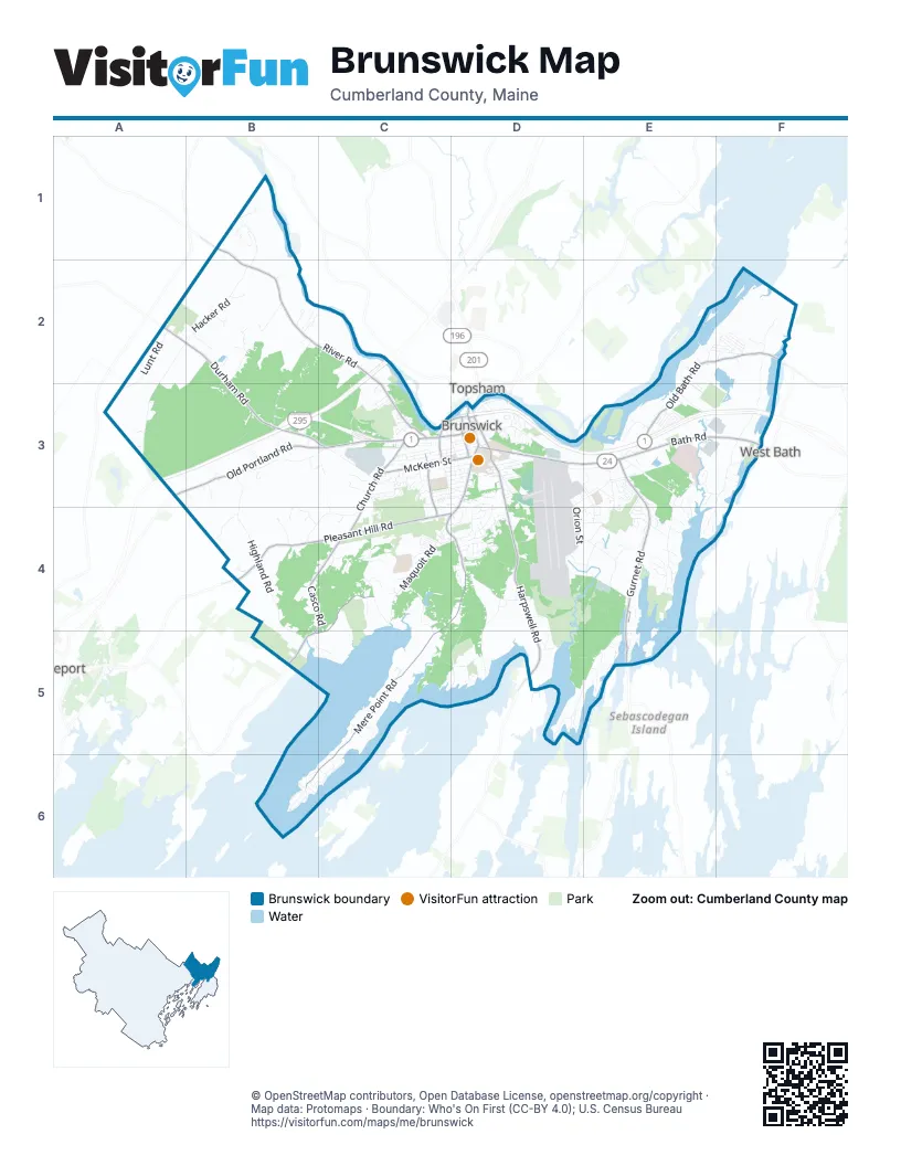
Street index of Brunswick
Each street on the sheet and the grid squares it crosses.
- Bath RoadD3, E3, F3
- Old Portland RoadA3, B3, C3
- Maine StreetD3, C4, D4
- Pleasant StreetC3, D3
- Mill StreetC3, D3
- Mason StreetD3
- Brunswick-Topsham BypassD3
- Gurnet RoadE3, E4, E5
- Harpswell RoadD3, D4, D5
- Sills DriveD3
- State Route 24E5
- State RoadF3
- Mere Point RoadC4, D4, C5, B6, C6
- River RoadB1, B2, C2, C3
- Pleasant Hill RoadB4, C4, D4
- Durham RoadA2, B2, B3, C3
- Old Bath RoadE2, F2, E3
- Bunganuc RoadC4, B5, C5
- Casco RoadB4, C4, B5
- Church RoadC3, C4
- McKeen StreetC3, D3
- Baribeau DriveC3, C4
- Union StreetD3
- Federal StreetD3
- Stanwood StreetC3
- Old Brunswick RoadF2
- Soper RoadB1
- Highland RoadB3, B4, B5
- Woodside RoadC3, C4
- Princes Point RoadD5, E5
- Collinsbrook RoadA2, A3
- Allagash DriveD3, E3
- Maquoit RoadC4
- Coombs RoadE4
- Lunt RoadA2, A3
- Hacker RoadA2, B2
- Pennellville RoadD4, D5
- Samuel Adams DriveD3, D4
- Simpsons Point RoadD4, C5, D5
- Hillside RoadB3, C3
- Columbia AvenueC3, D3
- Orion StreetD3, D4
- Jordan AvenueD3
- Adams RoadE3, F3
- Admiral Fitch AvenueD3, E3
- Merriconeag RoadD4
- Raymond RoadB4, C4
- Neptune DriveE3, D4, E4
- Middle Bay RoadD4
- Greenwood RoadC3
- Thomas Point RoadE3
- Rossmore RoadC4, C5
- Harding RoadF3
- Willow Grove RoadC3
- Lisbon RoadB1, B2
- Woodward Point RoadE4
- Old Pennellville RoadD4
- Ordinance RoadE4
- Peterson LaneF2, F3
- Madeline DriveB1
- Hemlock RoadD3, D4
- Brackett RoadB2
- Hennessey AvenueC3, D3
- Park RowD3
- Purinton RoadD4, E4
- Moody RoadB3
- Kimberley CircleE4
- Medical Center DriveE3
- Wildwood DriveE3, E4
- Dragon DriveC4
- Scarponi DriveC4
- Spring StreetC3, D3
- Bridge RoadF2
- Meadowbrook RoadD3
- Howards Point LaneF3, E4, F4
- Meadow RoadE3, E4
- Arrowhead DriveC3
- Pegasus StreetD3, E3, E4
- Bay Bridge RoadE2, F2
- Industrial ParkwayC3
- Beech DriveD3, D4
- Storer RoadE3
- Bostwick RoadB4
- Melden DriveD4
- Lombard StreetC3
- Crestview LaneC4
- North TrailB3, B4
- Range RoadC3
- Magean StreetC3, D3
- Dump RoadB4
- Parkview Circle DriveC4, D4
- Boody StreetC3, D3
- Bunganuc Landing RoadB5, C5
- Water StreetD3
- Central AvenueB6
- Weed WayB2
- Weymouth StreetC3, D3
- Carriage LaneB2
- Pennell WayD5
- Major Pope AvenueE4
- Farley RoadE3
- Botany PlaceC3, D3
- Ledge Brook CrossingB3
- Lindbergh CrossingE2, E3
- Deerfield DriveE3
- Thomas Point Beach RoadE3, E4
- Tufton StreetF2
- Thomas Point BeachE3, E4
- Merrymeeting RoadD3
- Theodore DriveF2
- Cushnoc LaneD4
- Cluf Bay RoadE4
- Cumberland StreetC3, D3
- Liberty CrossingD4, E4
- Toads LandingE5
- Breezy Point RoadE5
- Longfellow AvenueD3
- Garrison StreetD3
- Sumac DriveD4
- Tarratine DriveD4
- Long StreetE3
- Barrows StreetC3
- Bouchard DriveC3
- Point RoadE4, F4
- Tamarack DriveD4
- Jewell StreetD4
- MacMillan DriveC3, D3
- Wilson AvenueD3
- Glenwood HillB2
- Pine StreetD3
- Linnell CircleC4
- Amos WayC4
- Sparwell LaneD3
- Tree Farm RoadB3
- Country LaneC3
- Palmer StreetC3
- East Marginal RoadB6
- Antietam StreetE3
- Minott Shore RoadC5
- Rugosa WayC3
- Friendship StreetC3
- Belmont StreetC3, D3
- Wood Pond RoadB2
- Franklin ParkwayF2
- Gleed DriveC4
- Chamberlain AvenueD3
- November GolfE4
- Fox Run DriveC2, C3
- Signature DriveC3
- Quarry RoadB3, C3
- Tidal Run LaneC5, D5
- Sawyer RoadF3
- Bigelow Mountain RoadD4, E4
- Ocean DriveD5
- Board RoadE4
- Libby LaneD5
- Bagatelle LaneB3
- Woodland DriveB2, C2
- Four Wheel DriveE5
- McLellan StreetD3
- Beverly DriveF2
- James StreetE3
- Ward CircleE3, E4
- Thompson StreetC3, D3
- Burbank AvenueE3, D4, E4
- Watson DriveD3
- Gundalo Gap RoadC5
- Merriconeague RoadE4
- Christina DriveB3
- Hickory DriveE4
- Blackstone Club RoadC6
- Katahdin DriveD3, E3
- Resilient CircleE3, E4
- Graham RoadB1
- Rocky Hill DriveB2
- Larrabee Farm RoadC4
- Longreach RoadD5
- Larry LaneF2
- Kingfisher DriveB2
- College StreetD3
- Juniper RoadD4
- Katherine StreetD3
- Eastern Shore RoadC6
- Primrose LaneE2, F2
- Page StreetD3
- Guadalcanal DriveE3
- Leghorn LaneD4
- Damarin LaneC4
- Matthew DriveC3
- Meredith DriveC3
- Eagle Brook LaneF2
- White's Beach and CampgroundB2
- Hospital WayD3, D4
- Independence DriveE3
- Landing DriveE3
- Tanglewood DriveA3
- Varney LaneE3
- Peary DriveC3
- Rich RoadB3
- Tower LaneB3
- Goldenrod PlaceE2, E3
- Autumn View LaneB3
- Pinefields LaneE4
- Dionne CircleC3, C4
- Momo LaneB4, C4
- Cameron LaneB2, B3
- Hovey LaneD4
- Bowker StreetD3
- Otter TraceB4
- Intrepid StreetE3
- Seahawk AvenueD3, E3
- Laurel RoadD3, D4
- Richards DriveC3, D3
- Hawthorne StreetD3
- Wadsworth RoadD3
- Given Shipyard RoadE4
- West Marginal RoadB6
- Perryman DriveE3
- Emanual DriveC3
- Moore AvenueC3
- Rose Douglas LaneB2
- Forrestal DriveE3
- Cornerstone DriveB2
- Patriot DriveB3
- Oak Ridge RoadC4
- Enterprise DriveE3
- Pelican StreetD3, D4
- Riverview DriveD3
- Greystone LaneB3, C3
- Sandy Ridge RoadE3
- Granite Farm RoadC4
- Anchor DriveE3
- Heronwood DriveE4
- Buttermilk CoveE5
- Salt Marsh DriveC4
- Raspberry LaneB4
- South StreetD3
- Business ParkwayC3
- Gott LaneC4
- Bridle RoadE3, F3
- Pogy LaneE3
- Safari DriveA3
- Perreault WayB3, C3
- Turing RoadE4
- Hollis LaneE2
- Echo RoadB2
- Island View LaneE2
- Birch Island RoadB6
- Line DriveE3
- Cushing StreetD3
- Eagle DriveD4, E4
- Shobe AvenueC3
- Blueberry LaneD4
- Locust LaneD4
- Macomber WayD5
- Patricia RoadC3
- Pejepscot TerraceD3
- Young AvenueE3
- Cranberry DriveE3
- Running Brook LaneC4
- High StreetC3, D3
- Nancy DriveC3
- Chestnut RoadD4
- Bull Rock RoadF3
- School StreetD3
- Tibbetts DriveE3
- Karen LaneE3
- Sandhill DriveD4
- Pollard AvenueD3
- Shea StreetE3
- Candy LaneE2, F2
- Basswood RoadE3, E4
- Breckan RoadD3
- Zeitler Farm RoadC3, D3, D4
- Beacon DriveE3
- Osprey LaneD5
- Davis StreetD3
- Harry's DriveE2
- Bibber ParkwayC3
- Bluegrass DriveB3
- Cressey RoadD3
- Lynch StreetC4
- Hillcrest DriveB3
- Lamb Farm RoadC2, C3
- Nob Hill AvenueE5
- Windemere RoadC6
- Cheer Up LaneA3
- Capewoods DriveD4
- Pine Ledge LandingE4
- Cedar StreetD3
- Chloe Lyn LaneA3, B3
- Douglas StreetD3
- Coffin StreetD3
- Elaine DriveD3
- Owl DriveB2
- Whispering PinesE5
- Alexander RoadB4
- Shore RoadF3
- Snowberry LaneC4
- Youmans RoadC5
Things to do on the Brunswick map
Places on the map
- Bald Rock
- Blueberry Loop
- Bowdoin College
- Bowdoin Pines
- Brunswick Golf Club
- Brunswick High School
- Brunswick Upper Mall
- Chase Reserve
- Coffin Pond Recreation Area
- Cook's Corner Mall
- Cooks Corner Mall
- Cooks Corner Self Storage
- Coombs Property
- Cox Pinnacle
- Crimmins Field
- Crystal Spring Farm
- Edwards Field
- Great Island Chain
- Greater Commons
- Kate Furbish Preserve
- Lower Coombs Island
- Maine Army National Guard AFRC
- MaineHealth Parkview Campus
- Maquoit Bay Conservation Land
- Maquoit Bay Preserve
- McKeen Landing
- Mere Creek Golf Club
- Merrymeeting Park
- Merrymeeting Plaza
- Mid Coast Hospital
- Neptune Woods
- Pennellville Meadow
- Perryman Backwoods
- Pickard Field Athletic Complex
- Sawyer Park
- Shulman Park
- Thomas Point Beach & Campground
- Town Commons
- White's Beach & Campground
- Woodward Point Preserve
Next to Brunswick
- Freeport
- Topsham
- West Bath
© OpenStreetMap contributors, Open Database License, openstreetmap.org/copyright · Map data: Protomaps · Boundary: Who's On First (CC-BY 4.0); U.S. Census Bureau















