

Maine map
Portland map
About 69,568 people live here (Census Bureau, 2024 estimate). The sheet's index lists 300 streets; Maine Turnpike, Congress Street and Forest Avenue cross the most grid squares. Things to do inside the boundary: Children's Museum & Theatre of Maine, Maine Narrow Gauge Railroad Co. & Museum and Old Port.
Open the map (PDF, US Letter)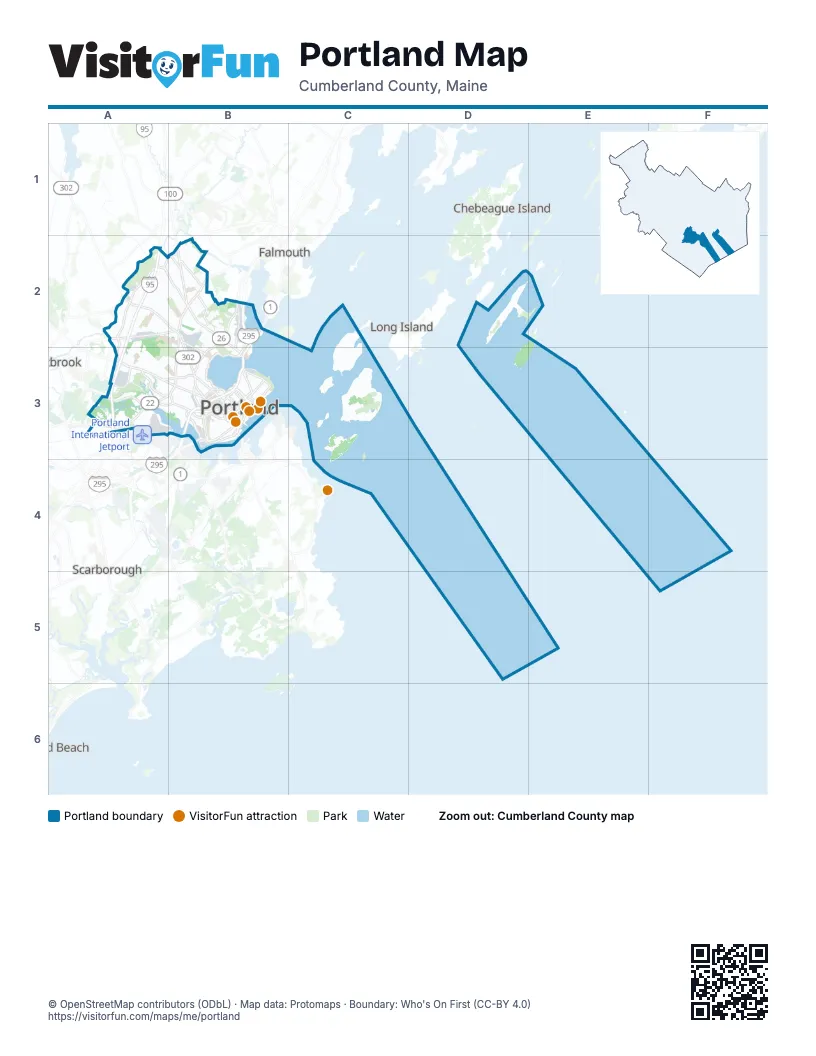
Street index of Portland
Each street on the sheet and the grid squares it crosses.
- Maine TurnpikeB2, A3, B3, A4, A5
- Falmouth SpurB2
- Tukey's BridgeC4
- Congress StreetA4, B4, C4, A5, B5
- Forest AvenueA3, B3, B4, C4
- Washington AvenueB2, B3, C4
- Riverside StreetB2, A3, B3, A4
- Fore River ParkwayB4, B5
- Warren AvenueA3, B3
- Auburn StreetB2, B3
- Allen AvenueB3
- Franklin StreetC4
- Saint John StreetB4, B5
- Commercial StreetC4, C5
- Park AvenueB4, D4
- West Commercial StreetB5, C5
- State StreetB4, B5, C5
- Veranda StreetC3, C4
- High StreetB4, C4, C5
- Veterans Memorial BridgeB5
- Johnson RoadA5
- Casco Bay BridgeC5
- Skyway DriveA5
- York StreetC4, C5
- Park StreetB4, C5
- Westbrook ArterialA4
- Bates StreetC4
- Larrabee RoadA4
- Martin Point BridgeC3
- Brighton AvenueA4, B4
- Ocean AvenueB3, C3, B4
- Stevens AvenueB3, B4
- Westbrook StreetA4, B4, A5, B5
- Cumberland AvenueB4, C4
- Deering AvenueB4
- Danforth StreetC4, B5, C5
- Marginal WayB4, C4
- Woodford StreetB4
- Rand RoadA4
- Valley StreetB4, B5
- Preble Street ExtensionB4
- Falmouth StreetB4
- Preble StreetB4, C4
- Elm StreetB4, C4
- Main StreetA4
- Revere StreetB4
- India StreetC4
- County RoadA5
- Stroudwater StreetA4
- Washington Avenue ExtensionB2
- Baxter BoulevardB4, C4
- Summit StreetB2, B3
- Presumpscot StreetC3, C4
- Capisic StreetA4, B4
- Eastern PromenadeC4
- Spring StreetC4, B5, C5
- Fore StreetC4
- Ray StreetB3
- Read StreetB3, B4
- Walton StreetB4
- Pearl StreetC4
- Oxford StreetC4
- Frost StreetB4
- Lambert StreetB2
- Middle StreetC4
- Somerset StreetC4
- Fox StreetC4
- Bedford StreetB4
- Portland StreetB4, C4
- Devonshire StreetB4
- Alder StreetC4
- Union StreetC4
- Temple StreetC4
- Allen Avenue ExtensionB3
- Adelaide StreetB3
- Blackstrap RoadB2
- Seashore AvenueD4, D5
- Perimeter RoadB4, A5, B5
- Island AvenueD4
- Pleasant AvenueB4, D4
- Riverside Industrial ParkwayB2, A3, B3
- Sunset RoadF3, D4
- Ludlow StreetA4, B4
- Sunset AvenueB4, D4
- Unum Park DriveA4, A5
- Shore RoadD5
- Brackett AvenueD4
- Yellowbird RoadB4, B5
- Canco RoadB3, B4
- Diamond AvenueD3, D4
- Brackett StreetB4, B5, C5
- Sherwood StreetB3, C3, C4
- Church RoadF3
- Lane AvenueA3
- Thompsons Point RoadB4, B5
- Central AvenueD4
- Holm AvenueA3, A4
- Clifton StreetB4
- Jackson BoulevardD5
- Maine AvenueB3
- Vaughan StreetB4, B5
- Woodlawn AvenueB3, B4
- Sewage Plant RoadC4
- Palmer AvenueB3
- Bradley StreetB4
- Anderson StreetC4
- Woodside DriveD3, D4
- Dartmouth StreetB4
- Western PromenadeB5
- Bancroft StreetB4
- Federal StreetC4
- Prospect StreetB4
- North StreetC4
- Pine StreetB5
- Taft AvenueA4
- TamarlaneB3
- Florida AvenueB3, D4
- Industrial WayA3
- Hicks StreetB3
- Beach RoadF3, D4
- Hussey RoadD4
- Coyle StreetB4
- Curtis RoadB2
- Neal StreetB4, B5
- West Shore DriveD3, D4
- Concord StreetB4
- Kennebec StreetB4, C4
- Pinecrest RoadA3, A4
- Douglass StreetB4
- Eben Hill DriveB3, C3
- Caleb StreetB4
- Massachusetts AvenueB4
- Bolton StreetB4
- Craigie StreetB4
- Whitney AvenueB4
- Frances StreetB4
- Edwards StreetB4
- Grant StreetB4
- Lancaster StreetB4, C4
- Virginia StreetB3
- Davis Farm RoadB2
- South RoadF3
- Warwick StreetA4
- Whitehead AvenueD5
- Ashmont StreetB4
- Crescent AvenueD4
- Murray StreetB3, B4
- Pheasant Hill DriveB3
- Brentwood StreetB4
- Ottawa AvenueD5
- Deepwood DriveB2, B3
- Hope AvenueB2
- Lester DriveB2
- Beacon StreetB4
- Delaware CourtB3
- Yale StreetB3
- Clinton StreetB4
- Southern AvenueB4
- Chestnut StreetC4
- Sheridan StreetC4
- Clark StreetB5, C5
- Glenwood AvenueB4
- Wayside RoadB4
- Regan LaneB3
- Lexington AvenueB3
- Dorothy StreetB3
- Saint James StreetB4
- Harris AvenueB3
- Auburn TerraceB3
- Plymouth StreetB3
- Leland StreetB4
- Payson Park DriveB3, B4
- Cassidy Point DriveB5
- International ParkwayA5
- Hutchins DriveA4, A5
- Rowe AvenueA4
- Hartley StreetB4
- BroadwayB3
- Alice StreetB2
- Rockledge AvenueD4
- Western AvenueB3, B4
- Belfort StreetA3, B3
- Cutter StreetC4
- Summit Park AvenueB3
- Christy RoadB3
- Ingalls RoadA3, D3, D4
- Chadwick StreetB5
- Wolcott StreetB4
- Free StreetC4
- McKinley CourtD3, D4
- Newbury StreetC4
- Washburn AvenueB4
- West StreetB5
- Owl's Nest RoadA4
- Noyes StreetB4
- Parsons Pond DriveB3
- Colonial RoadB4
- Hennessy DriveB3
- New Island AvenueD4
- Ridge RoadB3, C3
- Bishop StreetB3
- Greenwood LaneB3
- Riggs StreetA4
- Upper A StreetD4
- Cleeve StreetC4, D4
- Pineloch DriveB3
- Lyseth Moore DriveB3
- Newton StreetB3
- Princeton PinesB3
- Tucker AvenueA3
- William StreetB4
- Winding WayA4, D4
- Lawn AvenueB4
- Sherman StreetB4
- Vannah AvenueB4
- Rainbow Mall RoadB3
- Highland StreetB4
- Providence StreetB3, C3
- Roaring Brook RoadB2, B3
- Garden AvenueB4
- Hobart StreetB4
- Abby LaneB2
- Reed AvenueD4
- Hanover StreetB4, C4
- Chapel AvenueB4
- Pitt StreetB4
- Woodfield RoadA4, B4
- River's Edge DriveA4
- Morning StreetC4
- Pennell AvenueB3
- Bramblewood DriveB3
- Back Cove Estates RoadB4
- Huntington AvenueB3
- East Kidder StreetB3, C3
- Harvard StreetB3
- Oakdale StreetB4
- Jeanne StreetB4
- Shepherd LaneB3
- Maine State PierC4
- Carter StreetB2
- West Commonwealth DriveB3
- Gleckler RoadB4
- Ballfield RoadD4
- Pleasant StreetC4, C5
- Webb StreetA4
- Alder Brook RoadD4
- Hersey StreetB4
- Milton StreetB3
- Crestview DriveB2
- Dennett StreetA4
- Emery StreetB5
- Rockland AvenueB4
- Nancy LaneD4
- Wellington RoadB4
- Elipse AvenueB4
- Stroudwater RoadA4
- Elizabeth RoadB4
- Holiday DriveB3
- Northwood DriveB3
- Winter StreetB5, C5
- Arboretum RoadB4
- Garrison StreetA4
- Carlyle RoadB4
- Vermont AvenueB3, D4
- Market StreetC4
- Gilman StreetB4, B5
- Penn AvenueB3
- Center StreetC4
- Mabel StreetB4
- Racine AvenueB3
- Tolman RoadD4
- Alba StreetB4
- Alpine RoadB3
- Front StreetB4, C4
- Pine Tree Industrial ParkwayA4
- Montrose AvenueB4
- Portland Fish PierC4, C5
- Brook RoadB3
- County WayB4, B5
- Dole DriveB3
- Codman StreetB4
- Maggie LaneB3
- Walnut StreetC4
- Deering StreetB4, C4
- Euclid AvenueA3
- Parsons RoadB4
- Edgeworth AvenueB4
- Four Winds RoadA4, B4
- Longview DriveB2
- Granite StreetB4
- Seaward PointF3
- Fessenden StreetB4
- Bailey AvenueA3, B3
- Longwood DriveA4, B4
- Oak StreetC4
- Starbird RoadA4
- Bramhall StreetB4, B5
- Dorset StreetA4
- Westminster AvenueB4
- Mackworth StreetB4
Things to do on the Portland map
Places on the map
- ACE Ballfield
- Back Cove Trail North park
- Back Cove Trail South park
- Back Cove Trail West
- Ballfield Woods
- Beaver Ponds
- Brooklawn Memorial Cemetery
- Capisic Pond Park
- Casco Bay High School
- Catfish Rock
- Cliff Island
- Cranberry Swamp
- Cushing Island
- Cushings Island Conservation
- Deering Oaks Park
- Dougherty Field
- Eastern Promenade
- Evergreen Cemetery
- Evergreen Cemetery Woods
- Fore Points Marina
- Fore River Sanctuary
- Fort Levett
- Great Diamond Island
- House Island
- Hundred Acre Woods
- Jewell Island
- Kennedy Beach
- Landfill loop
- Little Diamond Island
- Lyman Moore Middle School
- Maine Medical Center
- Maine Yacht Center
- Mayor Baxter Woods
- Northern Light Mercy Hospital
- Ocean Avenue Recreation Area
- Peaks Island
- Peaks Island Land Preserve
- Portland International Jetport
- Presumpscot River Preserve
- Riverside Golf Course
Next to Portland
- Chebeague Island
- Falmouth
- Long Island
© OpenStreetMap contributors, Open Database License, openstreetmap.org/copyright · Map data: Protomaps · Boundary: Who's On First (CC-BY 4.0)