

Maine map
York map
About 14,179 people live here (Census Bureau, 2024 estimate). The sheet's index lists 300 streets; Maine Turnpike, US Route 1 and Cider Hill Road cross the most grid squares. Things to do inside the boundary: Nubble Lighthouse and York's Wild Kingdom.
Open the map (PDF, US Letter)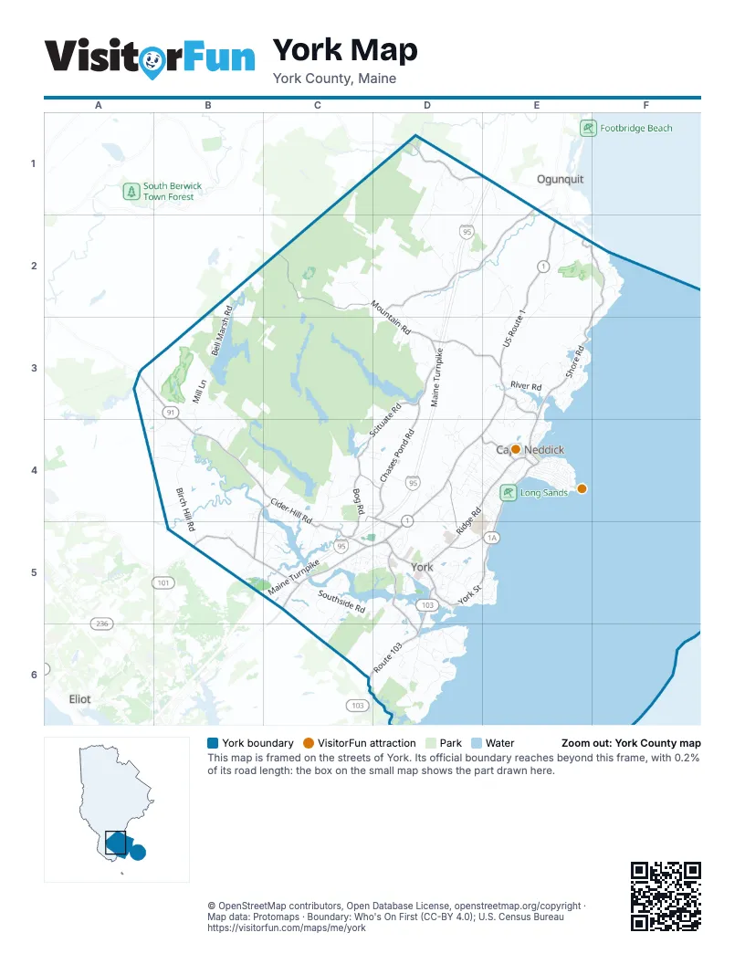
Street index of York
Each street on the sheet and the grid squares it crosses.
- Maine TurnpikeD1, E1, D2, D3, D4, C5
- US Route 1E2, E3, D4, E4, C5, D5
- York StreetD5, E5
- Long Beach AvenueE4, E5
- Spur RoadC4, D4, D5
- Cape Neddick RoadE3, E4
- Main StreetE4
- Ocean AvenueE4
- Church StreetE4
- Railroad AvenueE4
- Cider Hill RoadA3, B3, B4, C4, C5
- Route 103D5, C6, D6
- Lilac LaneD5
- Mountain RoadC2, D2, D3, E3
- Shore RoadE2, F2, E3, F3, E4
- Chases Pond RoadD3, D4
- Clay Hill RoadE1, D2, E2
- Scituate RoadD3, C4, D4
- Beech Ridge RoadB5, C5
- Ridge RoadD4, E4, D5
- Ogunquit RoadD1, E1
- Long Sands RoadD5, E5
- Bog RoadC4, C5
- Scotland Bridge RoadB4, C4, B5
- Old Post RoadD4, D5
- Organug RoadD5
- Short Sands RoadD4, E4
- Seabury RoadD5, D6
- Agamenticus RoadE1
- Josiah Norton RoadD1, D2
- Birch Hill RoadB4, B5
- Pine Hill RoadE2, E3
- North Village RoadD1, D2
- Southside RoadC5, D5
- Logging RoadD2, E2, E3
- Bell Marsh RoadB2, B3
- Nubble RoadE4
- Mill LaneB3, B4
- Raynes Neck RoadD6
- Bartlett RoadC5, D5, C6
- Fall Mill RoadC4, C5
- Greenleaf Parsons RoadD2, D3
- Western Point RoadD6
- Woodbridge RoadD5
- Animal Park RoadE4
- River RoadE3
- Turner DriveD2, E2
- Brave Boat Harbor RoadD6
- Woodside Meadow RoadC5, C6
- Lindsay RoadD5
- Carrie Lynn LaneC5, C6
- Caincrest RoadC5
- Old Mountain RoadC2
- Rogers RoadD4, E4
- Beacon StreetD4, E4
- Fieldstone Estates RoadD4
- Cycad AvenueE4
- Raydon RoadD5
- Meadowlark DriveD4
- Brixham RoadB3, A4, B4
- Airport DriveE4
- Pine Mountain RoadE3
- Argo Point LaneD6
- Norwood Farms RoadD5, E5
- Riverwood DriveB5, C5
- Marsh Brook LaneD2
- Godfrey Cove RoadD6
- Sewells Pasture RoadD3
- Sunrise TerraceC4, D4
- Linscott Road SouthB3, B4
- Saltwater DriveB5, C5
- Raydon Road ExtensionD5
- Perkins DriveC4, D4
- Henri WayE1
- Mt Agamenticus RoadC2
- BroadwayE4
- Agamenticus AvenueE3
- Bald Head Cliff RoadF2
- New Town RoadD4
- Linscott Road NorthB3
- Barrell's GroveC5
- Donica RoadD4, D5
- Payneton Hill RoadB4
- Clark RoadE3
- Leisure LaneC5
- Freeman StreetE4
- Hooper Shores RoadC4
- Groundnut Hill RoadD2, D3
- Robert Stevens DriveE4, D5, E5
- Mallard DriveC5, D5
- Fall Mill Road ExtensionC4
- David DriveB4
- Payne RoadC6
- Railroad Avenue ExtensionE4
- Witchtrot RoadB3
- Trafton StreetD4, E4
- Darcy RoadD5
- White Birch LaneB4
- Bluestone LaneD4
- Sentry Hill RoadD5
- Old Country RoadE3
- County RoadD3
- Vineyard LaneE3
- Pepperell WayD6
- High Rock RoadD6
- Betty Welch RoadB5
- Jeffrey DriveC5
- Rams Head LaneC5
- Eldredge RoadD5
- Hannaford DriveC5, D5
- Ocean Avenue ExtensionE4
- Abbey RoadE3, E4
- Emus WayB4
- Organug LaneC5, D5
- Hutchins LaneE3
- Wanaque RoadE3
- Country Club RoadD5
- Webber RoadD4, E4, E5
- Osprey LaneD3, D4
- Mitchell RoadE4
- Kings RoadD6
- Hemlock AvenueD4, E4
- Walt Kuhn RoadE3
- Mill Ridge Farm LaneD4
- Surf Point RoadD6
- Dewey RoadD4, E4
- Carwin DriveD5, D6
- Ferncroft RoadD5
- Frost Hill RoadB4
- Indian TrailD5
- Simpson Hill DriveE3
- Kingsbury LaneB4
- Circuit RoadF2
- Pine Hill Road SouthE2
- Riversedge DriveE3
- Field AvenueD5
- New Boston RoadC4
- Brickyard CourtC5
- Styles LaneD4, E4
- Sargents LaneC4
- Tall Pines WayD4
- Steam Mill RoadE3, E4
- Grand Manor DriveD5
- Nicole RoadE4
- Fernald AvenueD5
- Stage Neck RoadD5
- Dean RoadD4, E4
- Barrell LaneD5
- Pine Hill Road NorthE2
- Shelton AvenueE4
- Winterbrook DriveD5
- Harris Island RoadD5
- Orchard Farm RoadC5
- Seawatch PathF2, F3
- Gunnison RoadE4
- Pudding LaneC4, C5
- Algonquin DriveD2, D3
- Graystone LaneD4
- Lock LaneD6
- Ferry Lane SouthC5
- Leavitt Farm LaneA3, B3
- Hemlock Ridge LaneA3, A4
- Rumsey RoadB4, C4
- Loraine DriveE3
- Tide Meadow LaneC4, C5
- Ossipee RoadE3
- Boban StreetD5
- Garrison AvenueE4, E5
- Phillips Cove RoadE3
- Spring StreetE4
- Sparrow LaneD4
- Old East Scituate RoadD4
- Summit LaneD5
- Rob's WayB5
- Godfrey Pond RoadD6
- Paul StreetD4, E4
- Winn TrailD1
- Ledgewood DriveD6
- Ocean Circle DriveE3
- Plaisted RoadD5
- Perkins CourtC4, D4
- Sylvan CircuitE3
- Intervale RoadE3
- Bayberry LaneE3
- Jennifer LaneD4
- Lois LaneE3, E4
- Harry StreetD4
- Rocky Hill RoadD6
- Harbor Side DriveD6
- High Pine RoadB4
- Wolf Creek RoadD3
- Wavecrest DriveE5
- Eureka AvenueD5, E5
- Snowdin RidgeD3
- Bay Haven RoadE4
- Spruce StreetD4, E4
- Mainley York Trailer ParkD4
- Foxtail DriveC5
- Bristol LaneD5, D6
- Highland AvenueE4
- Flint Rock DriveC5
- Glenn LaneD5
- Stoney BrookE2
- Ledge View LaneE2
- Chickadee DriveD4
- York Shore RoadA3
- Garey Mill RoadB2, B3
- Kimball Farm LaneC5
- Deer RunC5
- Key WayE3, E4
- Scott AvenueD5
- Pine StreetE4
- Maple StreetE4
- Abenaqui DriveE3
- Oak StreetE4
- Sheru LaneD5
- Major McIntire RoadB4
- Great Pasture RoadD3
- Pinecrest DriveB5, C5
- Scituate TrailD3
- Anbewold CircuitE3
- Horn RoadE4
- Michael DriveD4
- Brooks Farm RoadC4
- Greenacre DriveC5
- Teepee LaneD3
- Eber DriveD3
- Gertrude LaneD3
- Moulton Farm LaneD2
- Fort Hill Avenue ExtensionE4
- Prebble LaneD4
- Harvest LaneC5
- Milbury LaneD5, E5
- Old Sewall FarmD5
- Hales RoadD2
- Lobster Cove RoadD5
- Gardner's CrossingD6
- Candlewood LaneD4, D5
- Loop RoadE3
- Rowe Falls LaneB3
- Axholme RoadD5
- Cat Mountain RoadD3
- Smith Field LaneD4
- Larson LaneC5
- Blue Heron Cove RoadE3
- Eastern Point RoadE5
- Turnpike Access RoadD4
- Harriets WayB4
- Ellis LaneD1
- Parlin RoadE4
- Ocean House WayE4
- Burnt Marsh RoadE3
- Tarton RoadB4, B5
- Bald Head Cliff Road SouthF2
- Moulton LaneD5
- Bass Cove LaneC4, C5
- Blueberry LaneE4
- Davidson LaneD5
- Silver Ridge DriveD3
- Snap Hook DriveC5
- Riverview DriveE3
- Arnold LaneD3, D4
- Bayview AvenueD5, E5
- Laila LaneD1
- Gorgeana WayD5
- Old Mast RoadC4
- Church Street ExtensionE4
- Coastal Ridge DriveD5
- Witham WayD4
- Raccoon RidgeE2
- Adams RoadE3
- Ferry Lane NorthC5
- Old Chase Pond RoadD4
- Seabury Cove RoadD5
- Windmill Acres RoadD6
- Tall Oaks DriveE5
- Boston RoadD1
- Seal Point LaneD6
- Woods RunD4
- Sohier Park RoadE4
- Weares TraceE3
- Whittier WayB4
- Barrell Lane ExtensionD5
- Heron DriveD4
- Tree Tops LaneE2
- Harbour Hill RoadD6
- Roaring Rock RoadE5
- Jungle RoadD6
- Nighthawk DriveD4
- Georgia StreetD5
- Dabney LaneD5
- Pebble Cove RoadF2
- Bank RoadE4
- Seabreeze LaneD6
- Tremont StreetD5
- Deacon DriveC6
- Garrison PointE3
- Norton AvenueE4
- Beach StreetE4
- Creation LaneC5
Things to do on the York map
Places on the map
- Barrells Millpond
- Bell Marsh
- Bell Marsh Reservoir
- Big A
- Boulter Pond
- Braceys Swamp
- Brave Boat Harbor
- Bridges Swamp
- Cape Neddick
- Cape Neddick Golf Club
- Chases Pond
- Cliff House Maine
- Cranberry Swamp
- Dixon's Campgrounds
- Dolly Gordon Basin
- Folly Pond
- Fuller Forest Preserve
- Goodrich Park
- Highland Farm Preserve
- Hooper Swamp
- Kittery Water District Lands
- Lafcadio's Woods Preserve
- Lake Carolyn
- Libby's Oceanside Camp
- Long Sands
- McFeely Preserve
- McIntire Highlands Preserve
- Middle Pond
- Mount Agamenticus Conservation Region
- Mount Agamenticus Summit Area
- Near Point Preserve
- Ring Trail
- Rush Swamp
- Scituate Pond
- Smelt Brook Preserve
- The Ledges Golf Club
- Whippoorwill Swamp
- York Golf and Tennis Club
- York Harbor
- York Water District Lands
Next to York
- Eliot
- Ogunquit map
© OpenStreetMap contributors, Open Database License, openstreetmap.org/copyright · Map data: Protomaps · Boundary: Who's On First (CC-BY 4.0); U.S. Census Bureau















