

Michigan map
Dearborn map
About 106,377 people live here (Census Bureau, 2024 estimate). The sheet's index lists 300 streets; Michigan Avenue, Ford Road and Rotunda Drive cross the most grid squares. Things to do inside the boundary: Arab American National Museum, Ford Rouge Factory Tour and Greenfield Village.
Open the map (PDF, US Letter)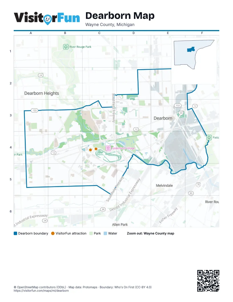
Street index of Dearborn
Each street on the sheet and the grid squares it crosses.
- Southfield FreewayC3, C4, D4, C5, D5
- Detroit Industrial ExpresswayE3, F3, D4, E4, D5
- Edsel Ford FreewayF3
- Michigan AvenueD3, E3, F3, A4, B4, C4, D4
- Ford RoadA3, B3, C3, D3, E3, F3, C4
- South Telegraph RoadA4, A5
- Wyoming StreetF2, F3, F4
- Evergreen RoadC3, C4
- West Warren AvenueD2, E2, F2
- North Telegraph RoadA3, A4
- Southfield Freeway Service DriveC3, C4, D4, D5
- North M 39 Service DriveC3
- South M 39 Service DriveC3, C4, C5
- Southfield DriveC4
- Ford Road - Evergreen Link Left Turn EastC3
- West Outer DriveB3, B4, B5, C5
- Greenfield RoadD2, D3, D4, E4, E5
- Miller RoadE2, E3, E4, F4, F5
- Rotunda DriveE3, C4, D4, E4, B5, C5
- Schaefer RoadE2, E3, E4
- Oakman BoulevardE2, E3
- Cherry Hill StreetA4, B4
- Oakwood BoulevardB4, C4, C5, D5
- Southfield Service DriveC4, D4, C5, D5
- Village RoadC4, D4, B5, C5
- Schaefer HighwayE2, E4, E5
- Golfview DriveB3
- Southfield RoadC2, C3
- Wyoming AvenueF3
- Cherry Hill RoadA4
- Hubbard DriveC3, D3, E3
- Carlysle StreetA5, B5, C5
- Mercury DriveC2, D2, D3
- South Gulley RoadA4, A5
- Monroe StreetB4, B5
- Chase RoadD2, E3
- South Military StreetB4, C4, C5
- Dix AvenueF4
- Tireman AvenueD2, E2, F2
- Ferney StreetF4, F5
- Beech StreetB4, C4
- North Gulley RoadA3, A4
- Southern StreetE3, F3
- North Military StreetB3, B4
- Pelham StreetC5
- Auto Club DriveC3
- Industrial StreetF4, F5
- Eagle StreetF3, F4
- South Brady StreetB4, C4
- Lonyo StreetF2
- Lone Oak DriveC3
- Eagle PassF4
- West Village RoadC4
- West Vernor HighwayF4
- Vernor HighwayF4
- Avondale AvenueA4
- Wren StreetF4
- Wilson DriveA3
- Industrial AvenueF5
- Beech AvenueB4
- McGraw StreetF3
- Dartmouth StreetA5, B5, C5
- Low Speed TrackC4, D4, C5
- High Speed TrackC4, D4
- Bingham StreetE2, E3
- Penn StreetA5, B5, C5
- Ternes StreetD2, D3
- Audette StreetB4, B5, C5
- Diversey AvenueD2, E2, F2
- Calhoun StreetE2, E3
- Orchard AvenueD2, D3
- Mead StreetD2, D3
- Maple StreetE2, E3
- Hartwell StreetE2, E3
- Notre Dame StreetA5, B5, C5
- Morross StreetD2, E2, F2
- Straight AwayC4, D4
- Reuter StreetE2, E3
- Manor StreetE2
- Doxtator StreetA3, B3
- Lawrence AvenueA3, B3
- Kendal AvenueE2, E3
- Steadman StreetD2, D3
- Prospect StreetD3, E3, D4
- Executive Plaza DriveC3, D3
- North Silvery LaneA3, A4
- Snow AvenueB4, C4, C5, D5
- Colson StreetD3, E3
- Town Center DriveC3, C4
- Steering and Handling CourseC4
- Blesser AvenueD2, E2
- Oxford StreetA5, B5
- Hemlock AvenueD2, E2
- Fairlane Woods DriveC3
- Payne AvenueD2, D3
- Park StreetB4
- Williamson StreetE2, E3
- Wilson AvenueA3, B3
- West Carroll Shelby WayB4, B5, C5
- Parker StreetB4, B5
- Horger StreetE2, E3
- Neckel AvenueE2, E3
- North Vernon StreetA3, A4
- Middlesex StreetE2, E3
- Princeton StreetA5, B5
- Grindley Park StreetB4, B5
- Marshall StreetA4, B4
- Gould AvenueD2, E2, F2
- Oak StreetA3, B3
- Madison StreetB5
- Walnut StreetC5, D5
- Barrie StreetD2, D3
- Linden StreetC5, D5
- Argyle AvenueE2, E3
- Coleman StreetD2, D3
- Pardee AvenueB4, B5
- Nowlin StreetB4, B5, C5
- Salina StreetF4
- Bailey StreetA4, A5
- Paul AvenueD2, E2
- Yinger AvenueD2, D3
- Lindenwood DriveD4
- Cornell StreetA4, A5, B5
- Kenilworth StreetE2, E3
- Academy StreetB4, B5
- North Martha StreetB3, B4
- Westwood StreetA4, A5
- Sheridan StreetA3, B3
- Banner StreetA4, A5
- Alber StreetD3, E3
- North Denwood StreetA3, A4
- Mildred StreetB3, B4
- North York StreetB3, B4
- Nona StreetB4
- Garrison StreetB4, C4
- Middlepointe StreetE2
- Lundy Parkway DriveD2, D3
- Cleveland StreetB4, B5
- Ruby AvenueD3, E3
- Snow CourtC5, D5
- Donald AvenueD3, E3
- North Lafayette StreetA3, A4
- Riverside DriveF4, F5
- Eagle LaneC4
- West Point StreetA5
- Rockford StreetA4, B4
- Pinehurst StreetE2
- Theisen StreetE2
- Henson AvenueE2
- Homestead DriveD3
- Appoline StreetE2
- Bennett StreetB5
- North Highland AvenueA3, A4
- Gertrude StreetB5
- Highview StreetA3, A4
- Olmstead StreetB4, B5
- Drexel StreetA3, A4
- Donaldson StreetB4, B5, C5
- Carroll Shelby Way EastC4, C5
- Reckinger RoadD4
- Beechmont StreetA4
- West RoadC3, D3, D4
- Vassar StreetB5
- Robindale AvenueA3, A4
- Hollywood StreetC5
- Culver AvenueC5
- Buckingham StreetA3, B3
- Geneva StreetB4, B5
- Mayburn StreetA3, A4
- Paul StreetD2, E2
- Claremont StreetA4
- Nightingale StreetA3, A4
- McKinley StreetB5
- North Elizabeth StreetB3, B4
- Kingsbury AvenueA3, A4
- North Franklin StreetA3, A4
- Melborn StreetB3, B4
- Palmer StreetD3
- Ash StreetC5
- Lincoln LaneC4
- Firestone StreetD3, D4
- Jonathan StreetE2, E3
- Curtis StreetD3
- Hollander StreetA3, B3
- Fair Lane DriveC3, C4
- Syracuse StreetB5
- Edgewood StreetC5
- Lodge LaneA3, B3
- Morley AvenueB4
- South Morrow CircleE2
- Littlefield BoulevardE2, F2
- Alice StreetB5
- Detroit StreetC5
- Park Lane BoulevardD3
- Haggerty AvenueE2
- Nicklaus DriveD4
- Newman StreetB4, C4
- AnthonyE2
- North Rosevere StreetA3, A4
- Jerome StreetD3
- North Waverly StreetA3, A4
- Merrick StreetB5
- Campbell StreetB5
- Venice StreetC5
- New York StreetA5
- Kean StreetA4, B4
- Richard DriveC3, C4
- South Commerce DriveE4
- East RoadD3, D4
- Columbia StreetB4, B5
- Golfcrest DriveB3, B4
- Stecker StreetF3
- Lincoln StreetB5
- Williams StreetB5
- Whitmore StreetB5
- Heather DriveD3
- Tenny StreetB4
- Hawthorne StreetB3
- South Highland StreetA4
- AppolineE2, E3
- The American RoadC4, D4
- Raymond AvenueC5
- Katherine StreetB5
- Schlaff StreetE3
- South Lafayette StreetA4
- Freda StreetE2
- Heritage ParkwayA5
- Robert StreetF3, F4
- Gregory StreetB4, B5
- Mohawk StreetA4
- Roosevelt StreetB5
- Hyatt Regency DriveC4
- Ross StreetA5
- Harding StreetB5
- Wisconsin StreetF2
- South Denwood StreetA4
- Beaver StreetB3
- Pine StreetC5
- Mason StreetB4
- Cass StreetB4, B5
- Coburn StreetA3
- Barclay StreetD3, E3
- Meridan StreetA4
- Woodside StreetC5
- McMillan StreetB3
- Henn AvenueD2, E2
- Edison StreetB4
- Chestnut StreetC5
- Woodcrest DriveB3, B4
- Rosalie StreetD3
- Lanson AvenueE3
- Woodworth StreetD3
- Kingsley StreetE2
- JonathanE2
- Edward StreetA3, B3
- Byrd StreetC5
- Chicago StreetA5
- Esper BoulevardE2
- Helen StreetD3
- Market DriveD3
- Polk StreetC5
- Whitcomb AvenueD2
- Willow StreetC5
- Indiana StreetF2
- Kentucky StreetF2
- Normile StreetF2
- Queen StreetB5
- Arthur AvenueD2
- Silvery Lane SouthA4
- Lauder StreetD2
- Francis StreetB4
- Lake Village BoulevardD4, E4
- Roulo StreetF4
- Bowles StreetE2, E3
- Shady Hollow DriveB3
- Knollwood DriveD4
- Elmwood StreetB4
- Sherwood CourtC5, D5
- Dudley StreetB5
- Fordson DriveA4, B4
- Korte StreetD3
- Mendota AvenueE2
- Hipp StreetC5
- Howard StreetB4
- Calvin StreetA5
- Lapeer StreetF4
- Boston StreetA5
- Mayfair StreetC5
- Union StreetA5
- Carlin StreetE2
- Westland StreetD3
- Commerce Drive NorthD4, E4
- Dacosta StreetB3
- Roselawn StreetF2
- Fairmount DriveA4
- Jonathon StreetE3
- Fairlane Meadow CourtD3
- North RoadD3
- Eastham RoadD4
- Osborn StreetE3
Things to do on the Dearborn map
Places on the map
- Advanced Technology Academy
- Arjay Miller Arboretum
- Beaumont Commons
- Bryant Junior High School
- Corewell Health Dearborn Hospital
- Corewell Health Dearborn Hospital Children's Pediatric Care Center
- Crowley Park
- CSX Rougemere Yard
- Dearborn Country Club
- Dearborn High Park
- Dearborn Hills
- Edison's Menlo Park
- Edsel Ford High School
- Fair Lane Lake
- Fairlane Commerce Park North
- Fairlane Commerce Park South
- Fairlane Meadows
- Fairlane North Shopping Center
- Fairlane Office Centre
- Fairlane Plaza
- Fairlane Town Center
- Ford Dearborn Development Center
- Ford Field
- Ford Research & Engineering Campus
- Ford Rotunda Center
- Ford World Headquarters Complex
- Ford-Wyoming Drive-In
- Greenfield Village
- HFE Fishway
- High Speed Track
- Homestead Drive
- Nowlin Field
- Parklane Towers
- River Rouge
- Schaefer Court
- Schaefer Yard
- Steering and Handling Course
- TPC Michigan
- Vehicle Dynamics Area
- Weiser Railroad
Next to Dearborn
- Allen Park
- Dearborn Heights map
- Melvindale
- River Rouge
© OpenStreetMap contributors, Open Database License, openstreetmap.org/copyright · Map data: Protomaps · Boundary: Who's On First (CC-BY 4.0)