

Michigan map
Wyoming map
About 78,559 people live here (Census Bureau, 2024 estimate). The sheet's index lists 300 streets; Clyde Park Avenue Southwest, Burlingame Avenue Southwest and Byron Center Avenue Southwest cross the most grid squares. Also on it: Battjes Lake, Battjes Park and Buck Creek Nature Preserve.
Open the map (PDF, US Letter)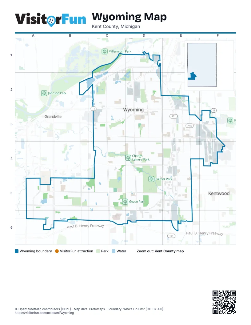
Street index of Wyoming
Each street on the sheet and the grid squares it crosses.
- Gerald R Ford FreewayC1, B2, C2, A5
- Byron Center Avenue SouthwestC2, C3, C4, C5, C6
- 44th Street SouthwestC4, D4, E4
- Division Avenue SouthE2, E3, E4, E5, E6
- 28th Street SouthwestC3, D3, E3
- 44th Street SoutheastE4, F4
- 28th Street SoutheastE3, F3
- Clyde Park Avenue SouthwestD1, D2, D3, E3, E4, E5, E6
- Wilson Avenue SouthwestB5, B6
- Chicago Drive SouthwestC1, D1, C2
- Gezon Parkway SouthwestC5, D5, E5, C6, D6
- Eastern Avenue SoutheastF3, F4
- 54th Street SouthwestE5
- Burton Street SouthwestC2, D2
- Godfrey Avenue SouthwestD1, D2
- Kellogg Woods Drive SoutheastE5
- Cesar E Chavez Avenue SouthwestD1
- Burlingame Avenue SouthwestD1, D2, D3, D4, D5, D6
- 56th Street SouthwestA5, B5, C5, D5, E5
- 52nd Street SouthwestA5, B5, C5, D5, E5
- 36th Street SouthwestC3, D3, E3
- Buchanan Avenue SouthwestE2, E3, E4, E5, E6
- Clay Avenue SouthwestE3, E4, E5, E6
- Roger B Chaffee Memorial Boulevard SoutheastF3, F4
- Lee Street SouthwestD1, C2, D2
- Prairie Parkway SouthwestC3, D3
- Michael Avenue SouthwestD2, D3, D4
- 32nd Street SouthwestC3, D3, E3
- Ivanrest Avenue SouthwestB5, B6
- 36th Street SoutheastE3, F3
- Jefferson Avenue SoutheastE3, E4
- Canal Avenue SouthwestA5, A6
- 40th Street SouthwestD4, E4
- 60th Street SouthwestA6, D6, E6
- Madison Avenue SoutheastF3, F4
- De Hoop Avenue SouthwestD2, D3
- Stafford Avenue SouthwestE3, E4, E5
- 50th Street SouthwestD5, E5
- 32nd Street SoutheastE3, F3
- Kenowa Avenue SouthwestA5
- Cleveland Avenue SouthwestD1, D2
- Linden Avenue SoutheastF3, F4
- Prairie Street SouthwestC3
- 40th Street SoutheastF4
- 64th Street SouthwestA6, B6
- 52nd Street SoutheastE5
- Wyoming Avenue SouthwestC2, C3, C4
- Havana Avenue SouthwestD1, D2, D3, D4, D5
- 34th Street SouthwestC3, D3, E3
- Porter Street SouthwestB2, C2, D2
- Taft Avenue SouthwestC2, C3, D3, C4
- Collingwood Avenue SouthwestC2, C3, C4
- Blanchard Street SouthwestC3, D3
- Den Hertog Street SouthwestD3, E3
- Pinnacle Drive SouthwestD4, C5, D5
- Floyd Street SouthwestC4, D4, E4
- Flamingo Avenue SouthwestD3, D4
- Indian Mounds Drive SouthwestC1
- 35th Street SouthwestD3, E3
- Boone Avenue SouthwestC3, C4
- Woodward Avenue SouthwestE2, E3
- Oriole Avenue SouthwestD3, D4
- Oakcrest Street SouthwestC3, D4, E4
- Perry Avenue SouthwestC3, C4
- Heron Avenue SouthwestD3, D4
- Haughey Avenue SouthwestE5, E6
- Cricklewood Street SouthwestD3, E3
- Ariebill Street SouthwestD4, E4
- Holliday Drive SouthwestC4, D4
- Buckingham Street SouthwestD3, E3
- Charlesgate Avenue SouthwestE2, E3
- Longstreet Avenue SouthwestE2, E3
- Milan Avenue SouthwestD3, D4
- Royal Oak Street SouthwestC3, D3
- Oak Valley Avenue SouthwestD3, D4
- McKee Avenue SouthwestE2, E3
- Palmer Park Drive SouthwestD4, D5
- 30th Street SouthwestC3, D3
- Colrain Street SouthwestD3, E3
- Hubal Avenue SouthwestD3, D4
- Martindale Avenue SouthwestD1, D2
- Raven Avenue SouthwestD3, D4
- Avon Avenue SouthwestC2, C3
- Palmdale Drive SouthwestC5
- 43rd Street SouthwestC4, D4, E4
- Colby Avenue SouthwestD3, D4
- Sharon Avenue SouthwestC2, C3
- Illinois Avenue SouthwestD3, D4
- Frontage Road SouthwestC1
- Metro Way SouthwestC6
- Highgate Avenue SouthwestE3
- Meyer Avenue SouthwestC2, C3
- Mulligan Drive SouthwestD5
- Wedgewood Drive SouthwestC3, C4
- 41st Street SouthwestD4, E4
- Village Drive SouthwestE5, C6
- 33rd Street SouthwestD3, E3
- Hillcroft Avenue SouthwestE3
- Quest Drive SouthwestA5, B5
- Walton Avenue SouthwestE4, E5
- Herman Avenue SouthwestD3, D4
- Rathbone Street SouthwestD1
- Federal Avenue SouthwestD1, D2
- 42nd Street SouthwestD4
- Bellevue Street SouthwestD4, E4
- Marcia Street SouthwestD4, E4
- Maplelawn Street SouthwestD4, E4
- Wrenwood Street SouthwestC2
- Wentworth Drive SouthwestC3, C4
- Whiting Street SouthwestD1
- Greenfield Avenue SouthwestC2
- Iowa Street SouthwestC4, D4, E4
- Barcroft Drive SouthwestC5, C6
- Union Avenue SoutheastF3
- Scenic River Drive SouthwestB5
- Birchwood Avenue SouthwestE3
- 26th Street SouthwestD2, E2
- Judd Avenue SouthwestD1
- Woodlake Road SouthwestC5
- Chateau Drive SouthwestC4, D4, C5, D5
- Averill Avenue SouthwestE5, E6
- Beverly Avenue SouthwestD2
- Roys Avenue SouthwestC2
- 38th Street SouthwestC4, D4
- Himes Street SoutheastE4, F4
- Del-Mar Drive SouthwestA5, B5, A6
- Hazelwood Avenue SouthwestC2, C3, C4
- Joosten Street SouthwestD2
- Beech Street SouthwestD4, E4
- 58th Street SouthwestD6, E6
- Copper River Avenue SouthwestB5
- Engle Street SouthwestD1
- Thornwood Street SouthwestC2
- Jacob Street SouthwestA5
- Del-Mar Village Drive SouthwestA5, A6, B6
- Nile Drive SouthwestB5, B6
- Bryant Street SouthwestD3, E3
- Kentfield Street SouthwestC3, D3
- Crippen Avenue SouthwestE5, E6
- Lamar Drive SouthwestC2
- Reserve Drive SouthwestB6
- Mallory Avenue SouthwestC3, C4
- Groveland Avenue SouthwestC3, C4
- Bayberry Farms SouthwestC5, C6
- Bend Street SouthwestB5
- Belden Avenue SouthwestD1, D2
- Boulevard Drive SouthwestC2, C3
- Blandford Avenue SouthwestD1, D2
- Central Avenue SouthwestC2, C3
- Ithaca Street SouthwestC2
- Marquette Street SouthwestD1
- Newstead Avenue SouthwestD2, D3
- Center Drive SouthwestC5, C6
- Health Drive SouthwestC6
- Hague Avenue SouthwestD2, D3
- Canterbury Street SouthwestD3, E3
- Beckie Drive SouthwestB5, C5
- Robin Avenue SouthwestD3
- Gladiola Avenue SouthwestC3
- Jean Street SouthwestE5
- Holly Street SouthwestE5
- Ancient Drive SouthwestC4
- Ayrshire Drive SouthwestA5, A6
- Antwerp Avenue SouthwestD2
- Bayberry Circle SouthwestC6
- Berkley Avenue SouthwestD1, D2
- Delwood Avenue SouthwestD1, D2
- Newport Street SouthwestC2
- Badger Avenue SouthwestE3, E4
- Lacrosse Street SouthwestC4
- Janet Avenue SoutheastE4, F4
- Wilbur Street SoutheastE4, F4
- Abbie Street SoutheastE4, F4
- Burt Avenue SoutheastE4, F4
- Farnham Street SouthwestE4
- Forest Grove Avenue SouthwestC2, C3
- Walter Avenue SoutheastE4, F4
- Tansy Trail SouthwestB6, C6
- Rogers Plaza SouthwestD3
- Thurston Street SouthwestE4
- Rogers Lane Avenue SouthwestD2, D3
- Noel Avenue SouthwestE2
- Minnie Avenue SouthwestD3, D4
- Golfbury Drive SouthwestC5
- Murray Street SouthwestE4
- Nagel Avenue SouthwestD1, D2
- Pickett Street SouthwestD5, E5
- Valleyridge Avenue SouthwestC4, C5
- Waldron Street SouthwestC2
- Plateau Drive SouthwestD5
- Plas Street SouthwestD3
- Kettle River Court SouthwestB5
- Melvin Street SouthwestC2
- Waterchase Way SouthwestC3
- Danton Drive SouthwestC5
- Burr Avenue SouthwestD3, D4
- Wendler Avenue SouthwestD1, D2
- Crooked Tree Road SouthwestC4
- R W Berends Drive SouthwestD4
- Galewood Avenue SouthwestD2
- Bluebird Avenue SouthwestC3
- Glenvale Drive SouthwestC5, D5
- Murray Street SoutheastE4, F4
- Bellevue Avenue SoutheastE4, F4
- Goodman Avenue SouthwestC3
- Timber Ridge Trail SouthwestC4, D4
- Belfield Street SouthwestD2
- Vicky Drive SouthwestB6, C6
- Lemyra Street SoutheastE3, F3
- Hickory Ridge Drive SouthwestB5, B6
- Pinehurst Avenue SouthwestE4, E5
- Lousma Drive SoutheastE3, F3
- Grenadier Drive SouthwestD4, D5
- Crossroads Commerce Parkway SouthwestD6
- 43rd Street SoutheastE4, F4
- Peckheath Drive SouthwestE3
- Charolais Drive SouthwestA5, A6
- Penny Lane SouthwestA6
- Cottondale Street SouthwestC5
- Parkcrest Drive SouthwestC5, D5, C6
- Elwell Street SouthwestE5
- Hillock Street SouthwestB5, B6
- Leroy Street SouthwestE4
- Lamar East Drive SouthwestC2
- Main Street SouthwestC6
- Danube Drive SouthwestB6
- Wesley Street SoutheastE3, F3
- Parkland Avenue SouthwestD3, D4
- Stonebridge Road SouthwestC4
- Crooked Pine Drive SouthwestC5
- Sentinal Street SouthwestD4, D5
- Berwyn Avenue SouthwestC2
- Dunbar Avenue SouthwestD3, D4
- Fieldstone Drive SouthwestC5
- Eagle Glen Avenue SouthwestD5
- 29th Street SouthwestC3
- Wilkshire Avenue SouthwestE4
- Lady Slipper Drive SouthwestB6, C6
- Blackburn Street SouthwestD2, E2
- Pine Dunes Drive SouthwestC5
- Mayflower Drive SouthwestD5
- Vancouver Avenue SouthwestC4, C5
- Rischow Drive SouthwestD5
- De Laat Avenue SouthwestD2
- Huizen Avenue SouthwestD2
- Golfcrest Drive SouthwestD5
- Clydon Avenue SouthwestC3
- Alger Street SouthwestD2, E2
- West Avenue SouthwestC3
- Thoroughbred Drive SouthwestB5
- 39th Street SouthwestC4, E4
- Celia Street SouthwestE3
- Barnum Street SouthwestD4, E4
- White Oak Street SouthwestA6
- Red River Avenue SouthwestB5
- Chableau Drive SouthwestD5
- Keegan Avenue SouthwestD5, D6
- Forest Park Drive SouthwestC4
- Quebec Avenue SouthwestC4, C5
- Pinecroft Lane SouthwestC5, D5
- Prairieville Drive SouthwestD4, E4
- Rivertown Circle SouthwestA5, B5
- Marble Avenue SouthwestC1, C2
- Greenview Drive SouthwestC4
- Prospect Avenue SoutheastE3, F3
- Abby Lane SouthwestA6
- Sheri Lynn Drive SouthwestC4, C5
- Knollview Street SouthwestC4
- Case Drive SouthwestA5
- Yorkton Avenue SouthwestC4, C5
- Madelyn Drive SouthwestD2, D3
- Easy Street SouthwestC5
- Opal Avenue SouthwestE3, E4
- Celia Street SoutheastE3
- Horton Avenue SoutheastE3, E4
- Mart Street SouthwestE2
- Yukon Drive SouthwestB5, B6
- Cannon Drive SouthwestC4
- Scarsdale Drive SouthwestC6
- Hudson Street SouthwestD2
- Bethanne Drive SouthwestC5, C6
- Rivertown Lane SouthwestA5, B5
- Magnolia Avenue SouthwestE4
- 31st Street SouthwestC3
- Simon Drive SouthwestC6
- Colrain Street SoutheastE3, F3
- Locksley Drive SouthwestD2
- Jenkins Avenue SouthwestD2, D3
- McCormick Drive SouthwestA5
- Crown Street SouthwestE4
- Palmaire Drive SouthwestC5
- Brookcrest Drive SouthwestA5
- Meadow Run Drive SouthwestD5
- Windcrest Avenue SouthwestA5
- Clarion Avenue SouthwestC2
- Plaster Creek Boulevard SouthwestE2
- Wadsworth Street SouthwestE4
- Crystal River Street SouthwestB5
- Nursrey Avenue SouthwestC3
- Sunvale Drive SouthwestD5
Places on the map
- Battjes Lake
- Battjes Park
- Buck Creek Nature Preserve
- Charles Lemery Park
- Gezon Park
- Godwin Heights High School
- Grand Rapids First
- Grand View Elementary School
- Hillcroft Park
- Hopewell Indian Mounds Park
- Ideal Park
- Jackson Park
- Kaufman Golf Course
- Kelloggsville High School
- Kelloggsville Park
- Lamar Lake
- Lamar Park
- Maple Hill Golf Course
- Marquette Park
- Meijer
- Menards
- Oriole Park
- Oriole Park Elementary School
- Palmer Park
- Pimple Lake
- Pine Grove Learning Center
- Pinery Park
- Plaster Creek
- Prairie Park
- Resurrection Cemetery
- Resurrection Life Church
- Rogers Plaza
- Rogers Plaza SW
- The Pines Golf Course
- The UPS Store
- University of Michigan Health - West
- Vanguard Charter Academy
- Walmart Supercenter
- West Elementary School
- West Godwin Elementary School
Next to Wyoming
- Grandville
- Kentwood
© OpenStreetMap contributors, Open Database License, openstreetmap.org/copyright · Map data: Protomaps · Boundary: Who's On First (CC-BY 4.0); U.S. Census Bureau