

Minnesota map
Bemidji map
About 15,733 people live here (Census Bureau, 2024 estimate). The sheet's index lists 300 streets; Paul Bunyan Expressway, Birchmont Drive Northeast and Bemidji Avenue North cross the most grid squares. Things to do inside the boundary: Paul Bunyan and Babe the Blue Ox.
Open the map (PDF, US Letter)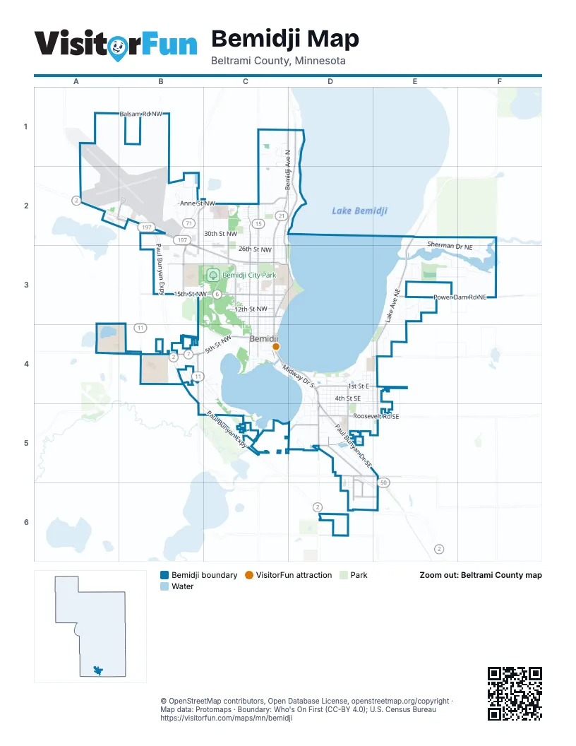
Street index of Bemidji
Each street on the sheet and the grid squares it crosses.
- Paul Bunyan ExpresswayA2, B2, B3, B4, B5, C5
- Bemidji Avenue NorthC1, C2, C3, C4
- Paul Bunyan Drive SoutheastD4, D5
- Paul Bunyan Drive NorthwestB2, B3, C3
- Midway Drive SouthC4, D4
- Washington Avenue SouthD5
- Paul Bunyan Drive SouthC4, D4
- State Highway 197B2, B3
- Voyageur HighwayB2
- Irvine Avenue NorthwestC2, C3, C4
- 15th Street NorthwestB3, C3
- 5th Street NorthwestB4, C4
- Middle School Avenue NorthwestB2, B3
- Division Street WestA4, B4
- Jefferson Avenue SouthwestB4
- Adams Avenue NorthwestA2, B2, B4
- Moberg Drive NorthwestA2, B2
- Birchmont Drive NortheastD1, C2, D2, C3, D3
- Lake Avenue NortheastE2, E3, E4
- Park Avenue NorthwestC2, C3, C4
- Power Dam Road NortheastE3, F3
- Roosevelt Road SoutheastD5, E5
- 23rd Street NorthwestB3, C3
- Anne Street NorthwestB2, C2
- 1st Street EastD4, E4
- Industrial Park Drive SoutheastD5
- Hannah Avenue NorthwestB2, C2, B3
- Grant Avenue SoutheastD4, D5
- 12th Street NorthwestC3
- Norton Avenue NorthwestC3
- Carr Lake Road SoutheastD5
- 10th Street NorthwestC3
- Ridgeway Avenue NorthwestC2, C3
- Lake Avenue SoutheastE4, E5
- Lakeview Drive SouthwestD5
- Mahnomen Drive SoutheastD5
- Mill Street NortheastD4, E4
- Cram Avenue SoutheastD5, D6
- 30th Street SoutheastD6, E6
- Rako Street SouthwestD5
- Oak Hills Road SoutheastD6
- Cardinal Road NorthwestA1, A2
- 23rd Street NortheastC3
- Herington Avenue SoutheastD6
- 15th Street NortheastC3
- Corrigan Avenue SoutheastD5, D6
- 10th Street NortheastC3
- Minnesota Avenue NorthwestC2, C3, C4
- Sherman Drive NortheastE2, F2, E3, F3
- Elliot Road NortheastE2, F2
- Balsam Road NorthwestA1, B1
- Beltrami Avenue NorthwestC2, C3, C4
- 30th Street NorthwestB2, C2
- South Lake Irving Drive SouthwestB4, C4, C5
- America Avenue NorthwestC3, C4
- 3rd Street SoutheastD4, E4
- Delton Avenue NorthwestC2, C3
- Brinkman Drive NortheastE3, F3
- 4th Street SoutheastD4, E4
- Lake Shore Drive NortheastD4
- Miles Avenue SoutheastD4, D5
- Gillett Drive NorthwestB2
- 2nd Street SoutheastD4, E4
- Wee Gwaus Drive SouthwestB4, B5, C5
- Event Center Drive NortheastD4
- Saint Onge Drive NortheastE3
- Pine Ridge Avenue NorthwestC2, C3
- Yellowhead Road SouthwestC5
- Naylor Drive SoutheastD5
- Calihan Avenue NortheastC2, C3
- Stoner Avenue SoutheastD4, D5
- Bardwell Drive NorthwestB2
- 14 Street NorthwestC3
- 6th Street SoutheastD5, E5
- Bixby Avenue NortheastC2, C3
- 26th Street NorthwestC3
- 11th Street NorthwestC3
- Mississippi Avenue NorthwestC3, C4
- 24th Street NorthwestB3, C3
- Juvenile Center DriveC3, C4
- 5th Street SoutheastD4, E4
- East Avenue NortheastE4
- 9th Street NorthwestC3
- Clausen Avenue SouthwestD4, D5
- South Railroad Street SoutheastD5
- Juniper Lane NorthwestC1
- Irving Beach DriveD4, D5
- 18th Street NorthwestC3
- Technology Drive NorthwestB2
- 29th Street NorthwestC2
- Cedar Lane NorthwestC2
- Lincoln Avenue SoutheastD4, D5
- Conifer Avenue NorthwestB3
- Scott Avenue SoutheastD4, D5
- 34th Street NorthwestB2, C2
- Pershing Avenue SoutheastD4, D5
- 28th Street NorthwestB2, C2
- Cherry Lane NortheastE3, F3
- Grotte Avenue NortheastE3, E4
- 4th Street NorthwestC4
- Railroad Street SoutheastD5
- 8th Street NorthwestC4
- 18th Street SouthwestC5
- Irving Access Loop SouthwestC4
- Central Avenue SoutheastD4, D5
- Amos Way NorthwestC1, C2
- Fern Street NorthwestB2
- Lake Boulevard NortheastC3, C4
- 7th Street SoutheastD5, E5
- Taft Avenue NortheastD4, E4
- Kay Avenue SoutheastD4, D5
- Laurel Drive NorthwestB2
- Jefferson Avenue NorthwestB4
- 3rd Street NorthwestC4
- Maurice Avenue NorthwestC3, C4
- Pioneer Street SoutheastD5
- Central Avenue NortheastD4
- 22nd Street NorthwestC3
- 20th Street NorthwestC3
- 21st Street NorthwestC3
- Tyler Avenue NortheastE3
- Shevlin Avenue SouthwestD4, D5
- Wood Avenue SoutheastD4, D5
- Valley View DriveE3
- Chippewa Drive NortheastE3
- 3rd Street NortheastD4
- Shedhorn Street SouthwestD5
- Roosevelt Road SouthwestD5
- Mc Kinley Avenue SoutheastD4, D5
- Gemmell Avenue SouthwestD4
- Richards Avenue SoutheastD4, D5
- 6th Street NorthwestC4
- Florence Lane NorthwestB2
- Grant Avenue NortheastD4
- Carol Drive NortheastE3
- Gould Avenue SoutheastD4, D5
- 16th Street NorthwestC3
- Deep Rock Loop SouthwestB4
- Arch Lane SouthwestC4
- Woodland Avenue SouthwestC4
- Net Way NorthwestB2
- Northern Cedar Avenue NorthwestC3
- Greenbriar Lane NortheastE3
- Dewey Avenue NortheastC3, C4
- Circle Pines Drive NorthwestC2
- Mag Seven Court SouthwestB4
- 13th Street NorthwestC3
- Apex Street NorthwestB2
- Country Lane NortheastE3
- Balsam Street NorthwestB3, C3
- 25th Street NorthwestC3
- 35th StreetC2
- Richards Avenue NortheastD4
- Stoner Avenue NortheastD4
- 5th Street NortheastD4, E4
- 19th Street NorthwestC3
- Gould Avenue NortheastD4
- Ivy Lane NortheastE3
- 2nd Street NortheastD4, E4
- Diamond Point Park NortheastD3
- Algoma Street NorthwestC2
- Power Drive NorthwestB2
- 19th Street NortheastC3
- Connelly Circle NortheastE3
- Gregg Court NorthwestB4
- Thorseon Boulevard NortheastD2
- 7th Street NorthwestC4
- Park Avenue SouthwestC4
- Highland Drive NortheastE3
- 2nd Street NorthwestC4
- 76th Street SouthwestE5
- 16th Street NortheastC3
- Railroad Street SouthwestC4
- Lambert Avenue SoutheastD5
- 17th Street NortheastC3
- Lakeside Drive NortheastE2, E3
- Hiway Avenue NorthwestB2
- Tamarack Avenue NorthwestC2
- 26th Street NortheastC3
- 24th Street NortheastC3
- Harrison Court SouthwestB4, C4
- Pine Crest Court NorthwestC2
- Whispering Meadows Court NorthwestB2
- Harding Court SouthwestC4
- Mississippi Avenue SouthwestC4
- Sherman DriveF3
- Fenske Avenue SoutheastD5, D6
- Irvingside Lane SouthwestC5
- Prairie Street NortheastE3
- Southview TerraceD5
- Riverside Drive NortheastE3
- Boring Court NorthwestB2
- Donald Avenue SoutheastD5
- 1st Street WestC4
- 29th Street NortheastC2
- Moonlight Lane SouthwestD5
- 12th Street NortheastC3
- Bunyan Avenue SoutheastD5
- Highway Maintenance DriveA2
- Robin LaneC4
- Roman Drive NorthwestC1
- 38th Street NorthwestC2
- Canoe Lane NortheastF3
- 36th Street NorthwestC2
- 39th Street NorthwestC2
- 37th Street NorthwestC2
- Shortcut Lane SouthwestD5
- 33rd Street NorthwestC2
- Carter Circle SoutheastD5
- Avion Lane NorthwestB2
- Robertson Drive NorthwestC2
- Wilson Avenue SoutheastD4, D5
- Ash Avenue NorthwestC3
- Inglewood Street NorthwestC2
- 15th Street SouthwestC5
- Linden Boulevard NorthwestC2
- 40th Street NorthwestC2
- Beartooth Avenue SouthwestD5
- 14th Street NortheastC3
- Oak Street SouthwestC4
- Itasca Loop NorthwestB3
- Neilson Avenue SoutheastD5
- Landscape Lane NorthwestC1
- 27th Street NorthwestC2
- 4th Street NortheastD4
- 7th Street SouthwestD5
- Birch Lane NortheastC3
- Jeanette Avenue NorthwestC3
- Norris Court NorthwestA2, B2
- Comfort Drive NorthwestB2
- Minnkota Avenue NorthwestC2
- Blue Spruce Lane NorthwestC2
- White Birch Avenue NortheastE2
- Larson Drive NortheastE3
- Waterfront Way SouthwestD5
- White Pine Street NortheastC1, D1
- Rice Avenue NorthwestC3
- Jacobs Way NortheastD4
- Betty Way NorthwestB4
- Gem Lane NortheastC2, D2
- Anne St.C2, D2
- Irvine Avenue SouthwestC4
- Norwood Drive NortheastC2
- 17th Street NorthwestC3
- 13th Street NortheastC3
- 9th Street NortheastC3
- Whispering Ridge NortheastE3
- Annebelle Street NortheastC2, D2
- Partnership DriveC3
- 31st Street NorthwestC2
- Convenience Lane SoutheastD6
- Vista Way NorthwestC2
- Walborg Avenue NortheastD4
- Ranch Circle SouthwestD5
- 32nd Street NorthwestC2
- Helen Street SoutheastD5
- Lyons Street SoutheastD6
- Fiber Way NorthwestB2
- Shoreacres Court SouthwestD5
- Waville Road NortheastE2
- Irving Oaks RoadC4
- Johanneson Avenue NorthwestB3
- Mikrantip Road SouthwestB4
- 8th Street NortheastC4
- Trustar Avenue NorthwestC3
- Scenic Shore Lane SouthwestD5
- Cross Street SouthwestD4
- Cloud Street NorthwestC2
- Connect Street SouthwestD4
- Silver Birch CourtC2
- Pleasant Court SouthwestC5
- Maple Leaf CourtC2
- America Avenue SouthwestC4
- Elm Street NortheastD1
- America Court NorthwestC3
- Old Rail Way SouthwestD5
- 18th Street NortheastC3, D3
- 27th Street NortheastC3
- Tracy Court NorthwestB2
- Saint Wright Drive NorthwestB3
- Taft Avenue SoutheastE5
- Hoover Court SouthwestC4
- Ross Lane NorthwestB4
- Molander Avenue SouthwestC4
- Juniper Circle NorthwestC1
- Kalee Court SothwestB4
- Doly Drive NorthwestB1
- Minnesota Avenue SouthwestC4
- Bush Court NorthwestB4
- 11th Street NortheastC3
- Alyce Court NorthwestB2
- Tod Court NorthwestB2
- Beltrami Court NorthwestC3
- Villa Court NorthwestC2
- Minnesota Court NorthwestC3
- 28th Street NortheastC2
- Mountain Ash Court NorthwestC2
- Appletree Court NorthwestC2
- Lassie Lane SouthwestC5
- Carved Woodduck Lane SouthwestC5
Things to do on the Bemidji map
Places on the map
- A L Restaurant Supply
- A.C. Clark Library
- Acme Tools
- Affinity Bank
- Airport Fire Station
- Aldi
- Algoma Park
- AmericInn
- Applebee's
- Bemidji City Park
- Bemidji High School
- Bemidji Middle School
- Bemidji Regional Airport
- Bemidji State University
- Brinkman Park
- Cameron Park
- Diamond Point Park
- FedEx Ship Center
- Gene Dillon Elementary
- Greenwood Cemetery
- J.W. Smith Elementary School
- Lake Irving
- Library Park
- Lincoln Elementary
- Menards
- North Central Door Company
- North Country Park
- Nymore Beach
- Nymore Park
- Paul Bunyan Center
- Paul Bunyan Mall
- Paul Bunyan Park
- Sanford Bemidji Medical Center
- Sanford Center
- Sanford Health Neilson Place
- Sanford Health, Behaviour Health Headwaters ACT
- Target
- The Home Depot
- The UPS Store
- Walmart Supercenter
© OpenStreetMap contributors, Open Database License, openstreetmap.org/copyright · Map data: Protomaps · Boundary: Who's On First (CC-BY 4.0); U.S. Census Bureau















