

Minnesota map
Beltrami County map
About 46,762 people live here (Census Bureau, 2024 estimate). The sheet's index lists 300 streets; Highway 89 Northwest, Highway 72 Northeast and State Highway 89 cross the most grid squares. Things to do inside the boundary: Big Bog State Recreation Area, Lake Bemidji State Park and Paul Bunyan and Babe the Blue Ox.
Open the map (PDF, US Letter)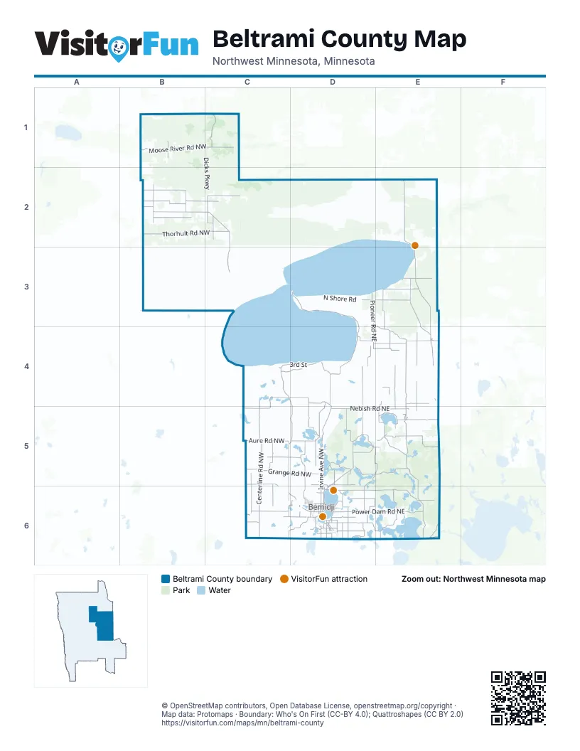
Maps inside Beltrami County
2 maps inside, from the street map of Beltrami County down.
City
Town
Street index of Beltrami County
Each street on the sheet and the grid squares it crosses.
- Paul Bunyan ExpresswayD6
- Highway 89 NorthwestB2, C2, C3, C4, D4, C5, D5, D6
- Irvine Avenue NorthwestD5, D6
- Bemidji Road NortheastD5, E5, D6
- Washington Avenue SouthD6
- Bemidji Avenue NorthD6
- Paul Bunyan Drive SoutheastD6
- Paul Bunyan Drive NorthwestD6
- 1st Street/US-2C6
- Midway Drive SouthD6
- Paul Bunyan Drive SouthD6
- State Highway 197D6
- Voyageur HighwayE4, D6
- Highway 72 NortheastE2, E3, E4, E5
- State Highway 89C4, C5, C6, D6
- 3rd StreetC4, D4
- Division Street WestC6, D6
- Walking Shield RoadC4, D4
- 15th Street NorthwestD6
- Carr Lake Road SouthwestD6
- Adams Avenue NorthwestD6
- Jefferson Avenue SouthwestD6
- County Road 15D5
- 5th Street NorthwestE4, D6
- Middle School Avenue NorthwestD6
- Clark Avenue NorthE4
- State Highway 72E5
- Glidden Road NortheastD6
- State Highway 72 / Clark Avenue SouthE4
- Moberg Drive NorthwestD6
- Reservation Highway 18D3, D4
- Birchmont Beach Road NortheastD6, E6
- Lumberjack Road NorthwestC4, D4, C5
- Moose River Road NorthwestB1, C1
- Scenic Highway NortheastE5, E6
- Power Dam Road NortheastD6, E6
- Thorhult Road NorthwestB2, C2
- Nebish Road NortheastD5, E5
- Centerline Road NorthwestC5, C6
- Hines Road NortheastE4, E5
- Cardinal Road NorthwestD5, D6
- Roosevelt Road SoutheastD6, E6
- Waldo Road NortheastE3, E4
- Fourtown Road NorthwestC1, C2
- Grange Road NorthwestC5, D5
- Turtle River Lake Road NortheastD5, E5
- Pioneer Road NortheastD3, D4
- Gull Lake Loop Road NortheastD5
- Shotley Road NortheastD3, E3
- Aure Road NorthwestC5
- Corlan Road NortheastE4, E5
- Pleasant Valley Road NorthwestD4, D5
- Benville Road NorthwestB2
- Debs Road NorthwestC4, C5
- Lookout Tower Road NortheastE5
- Sunflower Road NortheastE3, E4
- Sundown Road NorthwestC5, C6
- Battle River Road NortheastD3, E3, E4
- Hagali Road NortheastD5
- Trengove Road NorthwestC6
- Hamre Road NorthwestB2
- Island View Drive NortheastD5
- Polaris Road NorthwestD4, D5
- Everts Road NortheastD4, D5
- Becida Road SouthwestC6, D6
- Artesian Spring Road NortheastE3
- Spencer Road NorthwestC5, D5
- Buzzle Road NorthwestC5
- Todroff Road NorthwestB2, C2
- Flintlock Road NorthwestB2
- Thoren Drive NorthwestC5, C6
- Willow Creek Road NortheastE4
- Cormant Road NortheastD4, E4
- Great Divide Road NorthwestD5
- Malcolm Road NorthwestC2
- Alvwood Road NortheastE5
- Sunny Beach Road NortheastE3
- County Road 23D4, D5
- Hornet Road NortheastE4, E5
- Sumac Road NortheastD5, D6
- Mission Road NortheastE6
- Three Culverts Road NortheastD5, E5
- Dogwood Road NortheastD4, E4
- Puposky Road NorthwestD5
- Settler Road NorthwestB2
- County Highway 1B1
- Mission Road SoutheastE6
- 30th Street SoutheastD6
- Corral Road NortheastE4
- County Road 30E5
- Three Mile Road NortheastE4
- Tresselt Road NorthwestC2
- Lamon Road NortheastD6
- Wildwood Road NortheastD5
- Parkers Lake Road NortheastD6
- Centerline Road SouthwestC6
- Sunnyside Road SoutheastD6
- Northwood Road NorthwestC5, C6
- Birchmont Drive NortheastD6
- Ose Road NorthwestB2
- Kelliher Road NortheastE4
- Long Lake Drive NortheastD5, D6
- Marshall 54 NorthwestB1, B2
- Knappen Hill Road NortheastD5
- Lake Avenue NortheastD6
- Scenic Highway SoutheastE6
- North Plantagenet Road SouthwestD6
- Shiloh Drive NortheastE4
- Wolf Lake Drive SoutheastD6
- Battle Road NortheastD4
- Forest Route 2171E6
- Beltrami Line Road SouthwestC6, D6
- Morel Road NorthwestB1
- North Grace Lake Road SoutheastD6
- Irvine Avenue NortheastD4, D5
- Pinewood Road NorthwestC5
- Van Buren Avenue SoutheastD6
- Reservation Hwy 40D4
- Outpost Road NorthwestB2
- Big Bass Road NortheastD6
- Town Hall RoadE4, D5, D6
- Clearline Road NorthwestC6
- Coleman Lake Road NortheastE5
- Monroe Avenue SouthwestD6
- Fredenburg Road SouthwestC6
- Park Avenue NorthwestD6
- Mill Street NortheastD6
- Popplewood Road NortheastE5
- Mill Street EastD6
- Beltrami Line RoadD6
- Tyler Avenue SoutheastD6
- Arnson Creek Road NortheastD4
- Town Hall Road NorthwestD5
- Kile Road NortheastE5
- Wilton Hill Road NorthwestC6
- Anne Street NorthwestD6
- Sandpiper Road NortheastD5
- Swenson RoadD6
- Carr Lake Road SoutheastD6
- Pass Road NortheastE5
- 1st Street EastD6
- Arnson Road NortheastD4
- Sunnyside Road NortheastD6
- Oak Hills Road SouthwestD6
- Forest Rt 2167E6
- Main Street EastE4, E5
- County Road 48D6
- Big Lake Road NortheastD6
- Scribner Road NorthwestC6
- 23rd Street NorthwestD6
- Lakewood Drive NorthwestD6
- Archery Road NorthwestD6
- Gull Lake Loop Road NorthwestD5
- Lumberjack Road NortheastD4
- Blackduck Lake Road NortheastE5
- 4th Street NortheastE4, E5, D6
- Winter Sumac Road NortheastD5, D6
- New Bass Road NortheastD6
- Otter Road NortheastD6
- Centerline Road NorthC6
- Beaver Road NortheastD6
- Steenerson Lane NorthwestC2
- County Road 404D6
- Oak Hills Road SoutheastD6
- Polk Avenue SoutheastD6
- Ladyslipper Scenic Highway NortheastE6
- Industrial Park Drive SoutheastD6
- Island View Drive NorthwestD5
- Lakeview Drive SouthwestD6
- County Road 47E5
- Bass Lake Road NortheastD6
- Hannah Avenue NorthwestD6
- Grant Avenue SoutheastD6
- Main StreetD5, E5
- 12th Street NorthwestD6
- Norton Avenue NorthwestD6
- County Road 21 / Bemidji Road NorthwestD5
- Ladyslipper Scenic Highway SoutheastE6
- Dewey Avenue SouthwestC6, D6
- County Road 702B2
- Lakin Avenue NorthwestE4
- Scenic Highway Southeast / Scenic Highway NortheastE6
- 10th Street NorthwestD6
- County Highway 3C5
- Kelliher Road SouthwestE4
- Gate Lane NortheastE5
- County Road 36E4
- County Highway 14D6
- Ridgeway Avenue NorthwestD6
- Lake Avenue SoutheastD6
- Three Culverts Road SoutheastE5
- Bittern Road NortheastD5
- East Grace Lake Road SoutheastD6
- Gould Avenue NortheastE4, D6
- Summit Avenue WestE5
- Mahnomen Drive SoutheastD6
- 3rd Avenue NorthD5
- 2nd Street NortheastC6, D6
- Center Street EastB3
- Cram Avenue SoutheastD6
- County Road 24 / Aure Road NorthwestC5
- Byes Avenue NorthwestC6
- Reservation Hwy 17D4
- Main Street SouthwestD6
- 1st Street NortheastE5
- Rako Street SouthwestD6
- Forest Rt 2171 RoadE6
- 3rd Street SouthwestD6
- 3rd Avenue SouthwestD5
- Summit AvenueE5
- County 36D6
- Main St / Main Street NorthE5
- Spirit Avenue NorthwestD6
- 69th Avenue NorthwestE6
- 3rd Avenue SouthD5
- 23rd Street NortheastD6
- Herington Avenue SoutheastD6
- Buena Vista Acsess RoadD5
- 15th Street NortheastD6
- Corrigan Avenue SoutheastD6
- County Road 45D6
- County Road 700B2
- Winter Sumac Road NorthwestD5
- Dudrey StreetD5
- 10th Street NortheastD6
- Lakin Avenue SouthwestE4
- County Road 149E6
- 2nd Avenue NortheastD5
- Sunset Avenue SouthwestD6
- Dudrey Street NortheastD5
- Clearwater Lake RoadC5
- Whippoorwill RoadD6
- Forest Rd 2171E6
- County Highway 6B1
- Dike Trail NorthwestB1, B2
- Reservation Hwy 27C3
- North Shore RoadD3
- Dicks ParkwayC1, C2
- Reservation Highway 15D4
- Reservation Hwy 39C4, D4
- Morehouse Road NorthwestB1, C1
- Jelle Road NorthwestB2
- Rapid River Road NorthwestC2
- Dylan Road NorthwestB2
- Shoreline Drive NortheastD2, E2
- Balsam Road NorthwestC6, D6
- Birch Bark Road NortheastE5, E6
- Blanchard Trail NortheastD2
- Roughrider Road NorthwestC5
- Rabideau Lake Road NortheastE5
- Obrien Creek Road NortheastD4, D5
- Black Lake Road NortheastD5
- Nature Road NorthwestD5, D6
- Forest Rt 2206E5, E6
- Reservation Rd 24B3
- Reservation Hwy 14D4
- Forest Rt 2415E5
- Trails End Road NortheastD3, E3
- Rice Pond Road NortheastE5
- Jackpine Road NorthwestC5, D5
- South Boundary RoadC4
- Old Long Lake Road NorthwestC5, D5
- Eckles Road NorthwestD5, D6
- 23rd Street SoutheastD6
- Harvest Road NortheastD4
- Buckeye Road NortheastE4
- Radar Road NorthwestC5, D5
- Damon Lake Road NortheastE5, E6
- Shell Lake RoadC4
- Reservation Hwy 12D4
- Nelson Dam Road NorthwestC5
- Gunpowder Road NorthwestB2
- Werner Road NorthwestD5
- Perry Creek Road NortheastE4
- Teddy Road NorthwestC5
- Little Bass Lake Road NortheastD6
- Coyote Road NorthwestC5
- Big Dip Road NortheastE5
- North Shore TrailD3
- Great Valley RoadC5
- Wildlife Road NorthwestB1, B2
- Hillcrest Drive NortheastD5
- Konig Road NortheastE2
- Van Pelt Road NorthwestC2
- Blueberry Hill Road NorthwestB2
- Reservation Hwy 9C4
- Reservation Highway 10C4
- Neumann Road NortheastE4
- Two Town Road NorthwestC2
- Lanet Road NortheastE4
- Hales Road NortheastE5, E6
- Roen Road NorthwestC2
- Jones Townhall Road NorthwestC6
- Webster Lake Road NortheastE5
- Higgins Road NortheastD4
- Old Jefferson Drive NorthwestC6
- Hay Creek Road NortheastD5
- Sharp Rock Road NortheastD5, E5
- Wakish Road NortheastE2, E3
- Grant Creek Road NorthwestC5, C6
Things to do on the Beltrami County map
Places on the map
- Alaska Lake
- Alice Lake
- Anderson Lake
- Andrusia Lake
- Balm Lake
- Bass Lake
- Beltrami County Fairgrounds
- Beltrami Lake
- Bemidji
- Bemidji City Park
- Bemidji Town & Country Club
- Benjamin Lake
- Big Bass Lake
- Big Bog State Recreation Area
- Big Lake
- Big Rice Lake
- Black Lake
- Blackduck
- Blackduck Lake
- Bog Lake
- Bootleg Lake
- Boston Lake
- Buck Lake
- Buena Vista State Forest
- Bullhead Lake
- Burns Lake
- Burt Lake
- Buzzle Lake
- Carmelee Wildlife Management Area
- Carter Lake
- Castle Highlands Golf Course
- Chinaman Lake
- Hamre Wildlife Management Area
- Lake Bemidji State Park
- Lee Wildlife Management Area
- Mississippi Headwaters State Forest
- Red Lake State Forest
- Red Lake Wildlife Management Area, Supplement Unit
- Wapiti Wildlife Management Area
- Wolf Trail Wildlife Management Area
© OpenStreetMap contributors, Open Database License, openstreetmap.org/copyright · Map data: Protomaps · Boundary: Who's On First (CC-BY 4.0); Quattroshapes (CC BY 2.0)















