

Minnesota map
Clay County map
About 66,848 people live here (Census Bureau, 2024 estimate). The sheet's index lists 300 streets; 15th Avenue North, 90th Avenue North and 140th Avenue North cross the most grid squares. Things to do inside the boundary: Rourke Art Museum.
Open the map (PDF, US Letter)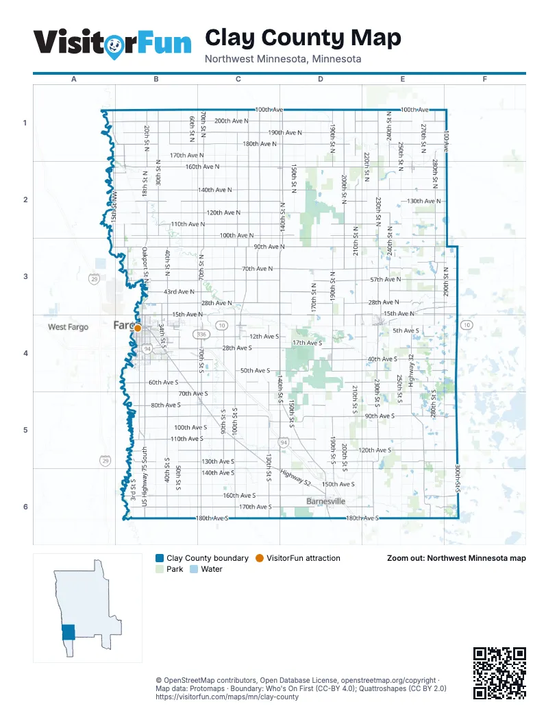
Street index of Clay County
Each street on the sheet and the grid squares it crosses.
- 140th Street SouthD4, D5, D6
- 70th Street SouthC4, C5, C6
- 140th Street NorthD1, D2, D3, D4
- US Highway 75 SouthB4, B5, B6
- 8th Street SouthB4, B5
- 34th Street SouthB4
- Main Avenue SoutheastB4
- 24th Avenue SouthB4
- 11th Street SouthB4
- Center AvenueB4
- Southeast Main AvenueB4
- State Street SouthwestC4
- Main AvenueB4
- State Street NortheastC4
- Main Avenue WestD6
- Center Avenue EastB4
- Front Street NorthD6
- Center Avenue WestB4
- Holiday Center Texas TurnB4
- 90th Avenue NorthA3, B3, C3, D3, E3, F3
- 28th Avenue NorthB3, C3, D3, E3, F3
- 60th Avenue SouthB4, C4, D4, E4, F4
- 160th Avenue SouthB6, C6, D6, E6, F6
- 15th Avenue NorthB3, C3, D3, E3, F3, B4, D4
- 70th Street NorthC1, C2, C3, C4
- Highway 32E4, E5, E6
- Highway 52B5, C5, C6, D6
- County Highway 52B4, D6
- 1st Avenue NorthB4
- 34 Street NorthB3, B4
- Wall Street Avenue NorthB3
- 90th Avenue NorthwestA3, B3
- 20th StreetB4
- 1st Street NorthwestE1, E2, B3, B4
- 21st Street SouthB4
- South Highway 52B4, B5
- 1st Street WestE2
- Wall Street Avenue NorthwestB3
- 7th Street NorthB4
- Halloway Avenue NorthC5
- Holloway Avenue SouthC5
- Holloway Ave NoC5
- 76th Avenue NorthA3
- 90th Avenue SouthB5, C5, D5, E5, F5
- 190th Avenue NorthB1, C1, D1, E1, F1
- 140th Avenue NorthA2, B2, C2, D2, E2, F2
- 160th Avenue NorthB2, C2, D2, E2, F2
- 70th Avenue NorthB3, C3, D3, E3, F3
- 180th Avenue NorthB1, C1, D1, E1, F1
- 120th Avenue SouthB5, C5, D5, E5, F5
- 57th Avenue NorthB3, C3, D3, E3, F3
- 200th Avenue NorthB1, C1, D1, E1, F1
- 110th Avenue SouthB5, C5, D5, E5
- 100th Avenue NorthB2, C2, D2, E2, F2
- 180th Avenue SouthB6, C6, D6, E6, F6
- 170th Avenue SouthB6, C6, D6, E6, F6
- 40th Avenue SouthB4, C4, D4, E4, F4
- 120th Avenue NorthB2, C2, D2, E2, F2
- 50th Avenue SouthB4, C4, D4, E4, F4
- 110th Street NorthC1, C2, C3, C4
- 28th Avenue SouthB4, C4, D4, E4
- 230th Street NorthE1, E2, E3
- 130th Avenue NorthB2, C2, D2, E2, F2
- 110th Avenue NorthB2, C2, D2, E2
- 80th Avenue SouthB5, C5, D5, E5, F5
- 130th Avenue SouthB5, C5, D5, E5
- 230th Street SouthE4, E5, E6
- 100th Street NorthC1, C2, C3, C4
- 100th Street SouthC4, C5, C6
- 200th Street NorthD1, D2, D3, D4
- 43rd Avenue NorthB3, C3, D3, E3, F3
- 210th Street NorthD1, D2, D3, D4
- 40th Street SouthB4, B5, B6
- 280th Street NorthE1, E2, E3, E4
- 240th Street NorthE1, E2, E3, E4
- 12th Avenue SouthB4, C4, D4, E4
- 130th Street SouthC4, C5, C6
- 90th Street SouthC4, C5, C6
- 190th Street NorthD1, D2, D3, D4
- 30th Street NorthB1, B2, B4
- 15th Street NorthwestA1, B1, A2, B2, A3, B4
- 40th Street NorthB1, B2, B3, B4
- 190th Street SouthD4, D5, D6
- 120 Street NorthC2, C3
- 14th Street SouthB4, B5
- 20th Street NorthB1, B2, B3, B4
- 120th Street NorthC1, C2
- Oakport Street NorthB2, B3
- Junction Avenue NorthE3, F3
- 10th Street NorthwestB1, B2, B3
- Broadway Street NorthwestB3
- 270th Street SouthE4, E5, E6
- Village Green BoulevardB4
- 75th Avenue NorthE3, F3
- 30th Avenue SouthB4, D4
- 20th Street SouthB4
- 4th Street SouthB4
- 5th Street SouthB4
- 4th Avenue SouthB4, D4
- 210th Avenue NorthwestA1, B1
- 5th StreetC2, D2, E3, E4
- 11th Street NorthB3, B4
- 200th Avenue NorthwestA1, B1
- County Road 78B4
- Rivershore DriveB4
- Main StreetB2, E4, C5
- 275th Street SouthE4, E6
- 7th StreetC2, D2, E4
- 2nd Avenue SoutheastB4, D6
- Parke Avenue SouthC4
- 14th Street NorthB3, B4
- Front StreetE3, E4
- Front Street SouthD6
- 155th Avenue NorthwestA2, B2
- Hobart StreetE4
- 282nd Street NorthE3
- 3rd Street SoutheastE2, C4, D6
- 1st Street SouthB4, C5
- Oakport StreetB3
- North 70th StreetC2
- 165th Street SouthD4
- 170th Avenue NorthwestA1, B1
- 160th Avenue NorthwestA2, B2
- 155th Street SouthD4
- 27th Avenue SouthB4
- County Highway 14F3
- 7th Street SoutheastB4, C4, D6
- 7th Street NortheastB4, D6
- 5th Avenue SoutheastD6
- 70th Avenue NorthwestB3
- Osborn Avenue NorthC5
- Main Avenue EastD6
- 4 Avenue SouthB4
- County Highway 12F3
- Bridge StreetB2
- Partridge Avenue NorthC4
- 8th Street NorthB4
- County Highway 16F2
- County Highway 18F1
- 12th StreetC4
- 8th Avenue NorthwestB4
- Northern Pacific Avenue WestE2
- South 275th StreetE6
- Main Street SouthB4
- Probsfield StreetB2
- East Front StreetE3
- County Road 9B4
- Northern Pacific Avenue EastE2
- South 160th AvenueB6
- South 160 AvenueB6
- King Trail Road NorthC5
- King Trail Road SouthC5
- Parke Avenue NorthC4
- County Road 19C4
- County Highway 8F4
- County Road 26D1
- County Highway 36B1
- Northern Pacific AvenueB4
- County Highway 19E6
- 22nd Street SoutheastA1
- 160th Avenue SouthwestB6
- County Highway 3C6
- 70th Avenue SouthB5, C5, D5, E5
- 80th Avenue NorthB3, C3, D3, E3, F3
- 100th Avenue SouthB5, C5, D5, E5, F5
- 150th Avenue SouthB6, C6, D6, E6
- 90th Street NorthC1, C2, C3, C4
- 170th Avenue NorthB1, C1, D1, E1, F1
- 250th Street SouthE4, E5, E6
- 140th Avenue SouthB6, C6, D6, E6
- 280th Street SouthE4, E5, E6
- 120th Street SouthC4, C5, C6
- 110th Street SouthC4, C5, C6
- 28th Street SouthB4, B5, B6
- 50th Street NorthB1, B2, B3, B4
- 50th Street SouthB4, B5, B6
- 80th Street NorthC1, C2, C3
- 60th Street NorthB1, B2, B3, B4
- 250th Street NorthE1, E2, E3, E4
- 3rd Street SouthB4, B5, C5, B6
- 80th Street SouthC4, C5, C6
- 210th Street SouthD4, D5, D6
- 200th Street SouthD4, D5, D6
- 150th Avenue NorthB2, C2, E2, F2
- 130th Street NorthC1, C2, C3
- 220th Street SouthE4, E5, E6
- 150th Street SouthD4, D5, D6
- 100th AvenueB1, C1, D1, E1
- 220th Street NorthE1, E2, E3
- 240th Street SouthE4, E5, E6
- 270th Street NorthE1, E2, E3, E4
- 170th Street NorthD1, D2, D3, D4
- 17th Avenue SouthB4, D4, E4, F4
- 150th Street NorthD1, D2, D3, D4
- 5th Street NorthB1, B2, B3, B4
- 170th Street SouthD5, D6
- 180th Street SouthD4, D5, D6
- 28th Street NorthB3, B4
- 260th Street SouthE5, E6
- 160th Street NorthD1, D2, D4
- 160th Street SouthD5, D6
- 60th Street SouthB4, B5, B6
- 290th Street NorthF3
- 5th Avenue SouthB4, E4
- 100 AvenueF1, F2
- 300th Street SouthF5, F6
- 180th Street NorthD1, D3
- 18th Street NorthB2, B3, B4
- 290th Street SouthF5, F6
- 110 AvenueF3, F5
- 147th Avenue SouthE6, F6
- 297th Street SouthF4
- 115th Avenue NorthE2
- 2nd Street NorthB3, C5
- 18th Street SouthB4, B5
- 60 Avenue SouthC4, D4
- 17th Street SouthB4
- 225th Street NorthE3, E4
- 110th Avenue NorthwestA2, B2
- 16th Street SouthB4, E4
- 6th Street SouthB4
- County Road 75B4
- 14th Avenue SouthB4, D4
- 82nd Avenue SouthB5, E5
- 19th Street SouthB4, B5
- 4th Avenue NortheastB4, D6
- 102nd Avenue SouthE5, F5
- 13th Street SouthB4
- North 130th StreetC1, C2
- 22nd Avenue SouthB4
- 130 Avenue SouthB5
- 20th Avenue SouthB4
- 16th Avenue SouthB4
- 100th Avenue NorthwestA2, B2
- 41st Avenue SouthB4
- 85th Avenue SouthC5, D5
- 33rd Avenue NorthD3, F3
- 10th Street SouthB4
- 130th Avenue NorthwestA2, B2
- 12th Street SouthB4
- 255th Street SouthE4, E6
- 8th Avenue NorthB4
- 9th Avenue SoutheastD6
- 15th Street SouthB4
- 2nd Avenue NorthB4
- 6th Avenue NorthB4, E4
- 73rd Avenue NorthB3, E3
- 173rd Avenue SouthE6
- 45th Street SouthB4
- 37th Avenue SouthB4
- 7th Street SouthB4
- 4th Avenue NorthB4
- 2nd Street NorthwestE2, B3, B4, D6
- 29th Avenue SouthB4
- 34th Avenue SouthB4
- 7th Street SouthwestB4, C4, B5, D6
- 7th Avenue SouthB4, D4
- 32nd Street SouthB4
- 26th Street SouthB4, E4
- 9th Street SouthB4
- Hartford StreetE4
- 36th Street SouthB4
- 143rd Avenue SouthE6, F6
- 3rd Avenue SouthB4
- 9th Avenue SouthB4
- 2nd Avenue SouthB4
- 46th Avenue SouthB4
- 70 Avenue SouthE5, F5
- 175th Street SouthD6
- Village Green DriveB4
- 2nd Street SoutheastE2, B4, C4, D6
- 7th Avenue NorthB4
- County Road 12C4
- 13th Avenue NorthB4
- 255th Street NorthE3, E4
- 9th Street NorthB3, B4
- 3rd Street NorthB3, B4, B5, C5
- 12th Street NorthB3, B4
- 2nd Street SouthB4, C5
- 4th Avenue NorthwestB4, D6
- 11th Avenue SouthB4
- Ridgewood BoulevardB4
- 33rd Street SouthB4
- 32nd Avenue SouthB4
- 18th Avenue SouthB4
- 10th Avenue SouthB4
- 44th Avenue SouthB4
- 5th Street NorthwestE2, B4, D6
- 190th Avenue NorthwestA1, B1
- 1st Avenue SouthB4, C4
- Joseph StreetE4
- 78th Avenue SouthE5, F5
- 5th Avenue NorthB4
- 168th Avenue SouthE6
- 5th Street SoutheastB4, C4, D6
- South Rivershore DriveB4
- 5th Avenue NortheastB4, D6
- 10th Street NorthB3, B4
- 97th Avenue NorthE2, B3, E3
- 13th Street NorthB3, B4
Things to do on the Clay County map
Places on the map
- Anderson WPA
- Barnesville
- Barnesville Wildlife Management Area
- Big Slough
- Blanket Flower Prairie SNA
- Bluestem Prairie SNA
- Buffalo River
- Buffalo River State Park
- Carlson WPA
- Christ Olson Lake
- Christianson WPA
- Clay WIA 408
- Comstock
- Dilworth
- Doran
- Doran Lake WPA
- Downer Prairie WPA
- Erickson Lake
- Felton
- Felton Pit & Wash Plant
- Felton Prairie SNA
- Flickertail Prairie WPA
- Flora Lake
- Flora Lake WPA
- Flowing Prairie Wildlife Management Area
- Flowing WPA
- Fuglie WPA
- Georgetown
- Glyndon
- Gruhl Wildlife Management Area
- Haugtvedt WPA
- Hawley
- Hawley Golf and Country Club
- Hawley WPA
- Hitterdal
- Hitterdal WPA
- Hoe Lake WPA
- Holte WPA
- Hoykens WPA
- Moorhead Municipal Airport
Next to Clay County
- Fargo
- West Fargo
© OpenStreetMap contributors, Open Database License, openstreetmap.org/copyright · Map data: Protomaps · Boundary: Who's On First (CC-BY 4.0); Quattroshapes (CC BY 2.0)