

Minnesota road map
I-35W in Minnesota map
I-35W is about 24 miles in Minnesota. TIGER/Line 2026 carries this number on only the northern part of the route; the Route Log gives 42 miles. It has 53 exits, from Exit 4B at mile 0 to Exit 31A at mile 24. It meets 12 highways, among them I-35, I-94 and I-494.
Open the map (PDF, US Letter)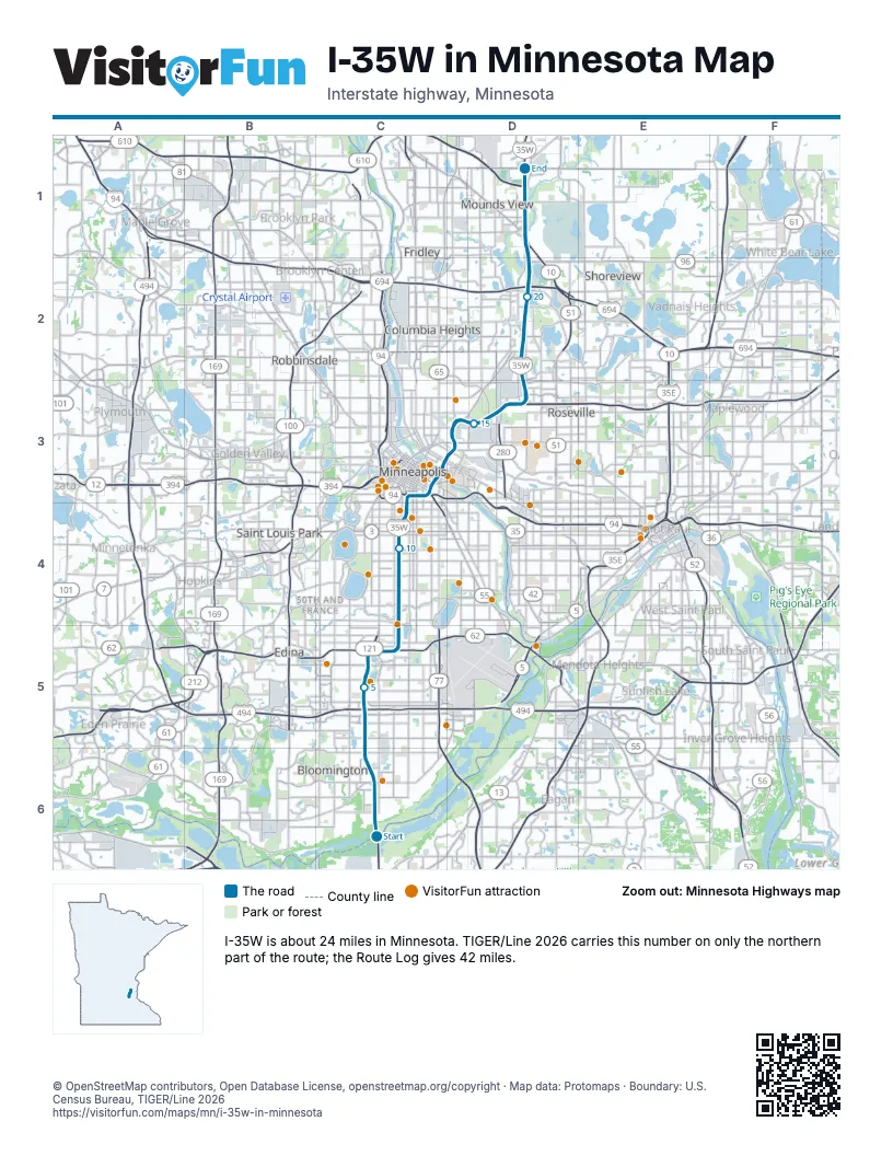
Exits on I-35W in Minnesota
Each exit in mile order, with its grid square.
- Exit 4Bmile 0, C6
- Exit 5mile 1, C6
- Exit 6mile 2, C6
- Exit 7Amile 2, C6
- Exit 7Bmile 3, C5
- Exit 8mile 4, C5
- Exit 8B-Cmile 4, C5
- Exit 9Bmile 4, C5
- Exit 9Amile 4, C5
- Exit 5Amile 4, C5
- Exit 5Cmile 4, C5
- Exit 5Bmile 4, C5
- Exit 8Cmile 4, C5
- Exit 9Cmile 5, C5
- Exit 10mile 6, C5
- Exit 112Amile 6, C5
- Exit 111Amile 6, C5
- Exit 12mile 7, C5
- Exit 11mile 7, C5
- Exit 13mile 8, C4
- Exit 14mile 10, C4
- Exit 15Amile 10, C4
- Exit 15Bmile 11, C4
- Exit 16Amile 11, C4
- Exit 233Amile 12, C3
- Exit 16Bmile 12, C3
- Exit 234Amile 12, C3
- Exit 233Bmile 12, C3
- Exit 17Cmile 12, C3
- Exit 17Amile 12, C3
- Exit 17Bmile 13, C3
- Exit 18mile 14, D3
- Exit 19mile 14, D3
- Exit 20mile 14, D3
- Exit 21mile 16, D3
- Exit 22Bmile 16, D3
- Exit 22Amile 16, D3
- Exit 23mile 17, D3
- Exit 24Amile 18, D2
- Exit 24Bmile 19, D2
- Exit 26Amile 19, D2
- Exit 26Bmile 20, D2
- Exit 41Bmile 20, D2
- Exit 41Amile 20, D2
- Exit 26Cmile 20, D2
- Exit 27mile 21, D2
- Exit 28Bmile 22, D1
- Exit 28Cmile 22, D1
- Exit 28Amile 22, D1
- Exit 28C-Bmile 23, D1
- Exit 29mile 23, D1
- Exit 30mile 24, D1
- Exit 31Amile 24, D1
Highways I-35W meets
Each highway it meets and the grid squares where they meet.
- I-35C6
- MN 65C6
- I-494C5
- MN 5C5
- MN 62C5
- I-94C3
- US 52C3
- US 12C3
- MN 55C3
- MN 280D3
- I-694D2
- US 10D1
Towns along I-35W in Minnesota
In mile order, with the grid square of each.
- Bloomingtonmile 0, C6
- Burnsvillemile 0, C6
- Richfieldmile 4, C5
- Edinamile 4, C5
- Minneapolismile 6, C5
- St. Anthonymile 15, D3
- Lauderdalemile 16, D3
- Falcon Heightsmile 16, D3
- Rosevillemile 16, D3
- New Brightonmile 18, D2
- Arden Hillsmile 18, D2
- Mounds Viewmile 22, D1
- Shoreviewmile 23, D1
- Blainemile 24, D1
Things to do on the I-35W in Minnesota map
© OpenStreetMap contributors, Open Database License, openstreetmap.org/copyright · Map data: Protomaps · Boundary: U.S. Census Bureau, TIGER/Line 2026