

Minnesota map
Waconia map
About 13,831 people live here (Census Bureau, 2024 estimate). The sheet's index lists 267 streets; State Highway 5, Sparrow Road and Sugarbush Lane cross the most grid squares. Also on it: Interlaken Woods, Interlaken Park and Ridgeview Medical Center.
Open the map (PDF, US Letter)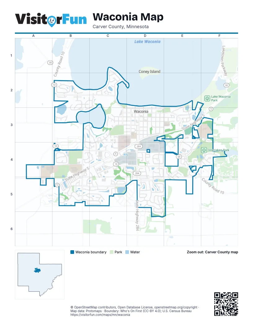
Street index of Waconia
Each street on the sheet and the grid squares it crosses.
- Lakeview Terrace BoulevardC1, C2
- Beachcomber BoulevardB2
- Braunwarth CircleB2
- Butternut LaneB2
- County Road 10B2, E4
- Courtland EastB2
- Courtland WestB2
- Dunsmore DriveB2, B3
- Honeysuckle LaneB2
- Lakeridge WayB2
- Sandbar CircleB2
- Seashell LaneB2
- Sugarbush LaneB2, C2, B3, C3
- Waconia Parkway NorthB2, C2, C3
- Whitecap LaneB2
- Willowbrooke LaneB2
- Woodlawn CircleB2, B3
- Alfred BoulevardC2
- Anita AvenueC2
- Barbary CircleC2
- Brent DriveC2
- Dana CircleC2
- Point DriveC2, D2
- Scott CircleC2
- Scott LaneC2
- Stacy CircleC2
- Tamarack LaneC2
- Wagners Bay CourtC2
- North Cedar StreetD2, D3
- North Elm StreetD2, D3
- North Oak StreetD2, D3
- North Orange StreetD2, D3
- North Spruce StreetD2, D3
- North Vine StreetD2, D3
- Beach RoadE2, E3
- Old Beach LaneE2, E3
- Paradise LaneF2
- Burandt BoulevardB3, C3, B4, C4
- Dunbury RoadB3
- Hickory CircleB3
- Kinder DriveB3, B4, C4
- Lester PointeB3
- Lockridge CourtB3
- Park Point RoadB3
- Sterling RoadB3
- WaterburyB3
- William Lake Shore DriveB3, C3, C4
- Cherry Street SouthC3, C4
- Cherrywood CircleC3
- Cherrywood LaneC3
- Cross Point RoadC3, C4
- Fair CircleC3
- Main Street WestC3, D3
- Mallard RoadC3
- Meadowlark CircleC3, C4
- North Walnut StreetC3
- Partridge CircleC3
- Pintail CircleC3
- Quail RunC3
- Ridgewood CourtC3
- South Cherry StreetC3
- South Redwood StreetC3
- South Walnut StreetC3
- Stein CircleC3, C4
- Sunset BoulevardC3
- Tanager RoadC3
- West 1st StreetC3, D3
- West 2nd StreetC3, D3
- West 3 1/2 StreetC3, D3
- West 3rd StreetC3, D3
- West 4th StreetC3, D3
- West 5th StreetC3, D3
- West Lake StreetC3, D3
- 3rd Street EastD3
- 4th Street EastD3
- 5th Street EastD3
- 8th Street EastD3, D4
- East 1st StreetD3, E3
- East 2nd StreetD3, E3
- East 3rd StreetD3, E3
- East Frontage RoadD3
- East Lake StreetD3, E3
- Hartmann DriveD3, E4
- Main Street EastD3, E3
- North Maple StreetD3
- North Olive StreetD3
- North Pine StreetD3
- Pine Street SouthD3, D4
- South Cedar StreetD3
- South Elm StreetD3
- South Maple StreetD3, D4
- South Oak StreetD3
- South Olive StreetD3
- South Orange StreetD3
- South Pine StreetD3
- South Spruce StreetD3
- South Vine StreetD3
- South Willow PlaceD3
- Spruce StreetD3
- Spruce Street SouthD3
- State Highway 284D3, D4, D5
- State Highway 5D3, E3, B4, C4, D4, B5
- Willow Place SouthD3
- Airport RoadE3, F3, E4
- Birch Street NorthE3
- Comorant CourtE3
- Egret LaneE3
- Interlaken CrossingE3
- Main StreetE3, E4
- Old Orchard RoadE3
- Regent LaneE3
- South Birch StreetE3
- South Hazel StreetE3
- Village WayE3, E4
- Vista BoulevardE3
- Vista WayE3
- Yellowstone TrailE3
- Firesteed CourtF3
- Firesteed RidgeF3
- Community DriveA4, B4
- Orchard RoadA4, A5
- Creekside CourtB4
- Creekside DriveB4, C4
- Eagle DriveB4
- Oak AvenueB4, B5
- Oak CourtB4
- Oak PlazzaB4, B5
- Oriole DriveB4
- Parkside LaneB4
- Pond CircleB4
- Pond CurveB4
- Pond LaneB4
- Waconia Parkway SouthB4, C4
- Wildcat WayB4
- Wildflower WayB4
- 10th Street WestC4, D4
- Cherry DriveC4
- Countryside RoadC4
- Creekside CircleC4
- Farm Line RoadC4
- Fischer WayC4
- Heather LaneC4
- Industrial BoulevardC4, D4
- Industrial Boulevard WestC4
- Larkspur LaneC4
- Lilac CourtC4
- Marketplace DriveC4
- Marketplace RoadC4
- Meadow Lake PlaceC4
- Mill LaneC4, C5
- Mockingbird DriveC4, C5
- Primrose LaneC4
- Provence LaneC4
- Stein DriveC4
- Strong DriveC4
- West 13th StreetC4, D4
- Wildhurst RoadC4, D4
- 10th StreetD4, E4
- 13th Street EastD4, E4
- 8th StreetD4
- Amber PointD4
- Brenda RoadD4
- Carver SquareD4
- Crosswinds CourtD4
- Crosswinds WayD4, D5
- Deerfield RoadD4, D5
- Depot DriveD4
- East 10th StreetD4
- East 13th StreetD4
- Farmhouse DriveD4, E4
- Fieldgate RoadD4
- Fox Run RoadD4
- Greenfield CircleD4
- Hunter SquareD4
- Linden CircleD4
- Mallard PlaceD4
- Night TrailD4
- Pine SquareD4
- Pinehill BoulevardD4
- Ravenwood CircleD4
- Ravenwood DriveD4, D5
- Skybrooke AvenueD4, D5
- Somerset DriveD4
- Spring Hill CircleD4
- Spring Hill RoadD4
- West 10th StreetD4
- Acorn WayE4
- Basswood CourtE4
- Copper CourtE4
- Cottonwood CourtE4, E5
- Eugenia WayE4, F4
- Hackberry CourtE4
- Hickory WayE4, E5
- Highland CourtE4
- Interlaken CourtE4, E5
- Interlaken ParkwayE4, F4
- Oakmont LaneE4
- Raymond DriveE4
- Roanoke CourtE4
- Shadywood LaneE4, E5
- Somerwood DriveE4
- Somerwood LaneE4
- Somerwood WayE4
- Sparrow RoadE4, B5, C5, D5, E5
- Stonegate CircleE4
- Interlaken Parkway NorthF4
- Lakewood CircleF4
- Meadow LaneF4
- Prairie View LaneF4
- 94th StreetA5, B5
- Victor CourtA5
- Bluebird DriveB5, C5
- Charleston LaneB5
- Fireside RoadB5
- Freedom LaneB5
- Goldfinch DriveB5, C5
- Greenleaf LaneB5
- Gusty DriveB5, C5
- Idlewild LaneB5
- Landsdown LaneB5
- Liberty LaneB5
- Manchester PlaceB5
- Nuthatch DriveB5, C5
- Oakpointe CourtB5
- Oakpointe DriveB5
- Patriot LaneB5
- Peitz AvenueB5
- Pembrooke LaneB5
- Prosperity LaneB5
- Raintree LaneB5
- Serenity LaneB5
- Spinnaker RoadB5
- Windmill Creek NorthB5, C5
- Windmill Creek SouthB5, C5
- Windy LaneB5, C5
- Barton StreetC5
- Breezy CourtC5
- Gale LaneC5
- Lenox DriveC5
- Longmeadow LaneC5
- Ravencroft RoadC5
- Redwing DriveC5
- Saint George StreetC5
- Tiffany LaneC5
- Wood Duck RoadC5
- 15th StreetD5
- Alva CourtD5
- Alva StreetD5
- Amblard WayD5, E5
- Campfire Drive EastD5
- Clearwater RoadD5
- Coney LaneD5
- Feather CircleD5
- Fischer DriveD5
- Fischer PointD5
- Fountain LaneD5
- Hilltop LaneD5
- Island CourtD5
- Island PassD5
- Mill RoadD5
- Moccasin DriveD5, E5
- Niagara StreetD5
- Sierra ParkwayD5
- Silver StreetD5, D6
- Starlight DriveD5
- Klein DriveF5
- Diamond PointD6
Places on the map
- ALDI
- AmeriVu Inn and Suites - Waconia
- AutoZone
- Bent Creek Park
- Carver County Fairgrounds
- Cedar Point Park
- City Square Park
- Clearwater Mills Park
- Culver's
- Dairy Queen
- Dollar Tree
- Fox Run Park
- Good Day
- Interlaken Park
- Interlaken Woods
- Interlaken Woods Park
- Kwik Trip
- Laketown Elementary School
- Lakeview Clinic
- Mackenthun's
- McDonald's
- Qdoba
- Reitz Lake Park
- Ridgeview Medical Center
- Starbucks
- Subway
- Taco Bell
- Target
- The Church of Jesus Christ of Latter-day Saints
- The UPS Store
- Tractor Supply Company
- Valvoline
- Vista Point Park
- Waconia 1 Collision & Auto Repair
- Waconia City Hall
- Waconia City Park
- Waconia Dodge Chrysler Jeep
- Waconia Library
- Waterford Park
- Wildhurst Park
Next to Waconia
- Coney Island
© OpenStreetMap contributors, Open Database License, openstreetmap.org/copyright · Map data: Protomaps · Boundary: Who's On First (CC-BY 4.0); U.S. Census Bureau















