

Minnesota map
Minneapolis-St. Paul map
The sheet's index lists 38 highways; US 169, I-94 and I-35 cross the most grid squares. Things to do inside the boundary: Afton State Park, American Swedish Institute and ArtReach St. Croix. Also on it: Andover, Apple Valley and Belle Plaine.
Open the map (PDF, US Letter)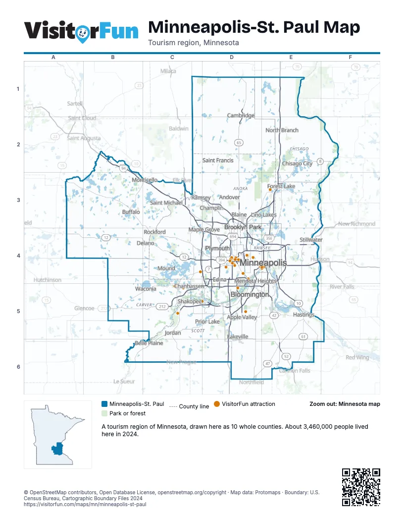
Highway index of Minneapolis-St. Paul
Each highway on the sheet and the grid squares it crosses.
- I-35D5, D6, E1, E2, E3
- I-35ED4, D5, E3, E4
- I-35WD3, D4, D5, E3
- I-94B2, B3, C3, C4, D4, E4
- I-394C4, D4
- I-494C4, D4, D5, E4, E5
- I-694D4, E4
- US 8E2, E3, F2
- US 10C3, D3, D4, E4, E5
- US 12A4, B4, C4, E4
- US 52E4, E5, E6
- US 61E4, E5, E6
- US 169B6, C3, C5, C6, D3, D4, D5
- US 212B5, C5, D4, D5
- MN 3D6
- MN 5B5, C5, D4, D5
- MN 7D4
- MN 13D5
- CH 15E4
- MN 25B4, B5
- CH 36E4
- MN 36D4, E4
- CH 37D4, E4
- CH 47D6, E6
- MN 47D3
- MN 51D4
- MN 55C4, D4, D5, E5
- MN 62D4, E4
- MN 65D1, D2, D3, D4
- MN 77D4, D5
- MN 95E4, F2
- MN 100D4, D5
- MN 101C3
- MN 121D4
- MN 149D5
- MN 252D3, D4
- MN 280D4
- MN 610C3, D3
Things to do on the Minneapolis-St. Paul map
- Afton State Park
- American Swedish Institute
- ArtReach St. Croix
- Bell Museum
- Bohemian Flats Park
- Bruentrup Heritage Farm
- Cathedral of Saint Paul
- Como Park Zoo & Conservatory
- Coon Rapids Dam Regional Park
- First Avenue
- Fish Lake Regional Park
- Franconia Sculpture Park
- General Store of Minnetonka
- Goldstein Museum of Design
- Guthrie Theater
- Historic Fort Snelling
- James J. Hill House
- Lake Hiawatha Park
- Lebanon Hills Regional Park
- Loring Park
- Lyndale Park
- Mall of America
- Maplewood Mall
- Midtown Global Market
- Mill City Museum
- Mill Ruins Park
- Minneapolis Chain of Lakes Regional Park
- Minneapolis Institute of Art
- Minnehaha Regional Park
- Minnesota Children's Museum
- Minnesota History Center
- Minnesota Landscape Arboretum
- Minnesota Museum of American Art
- Minnesota Renaissance Festival
- Minnesota State Capitol
- Minnesota Zoo
- Mystic Lake Casino Hotel
- Nickelodeon Universe
- Noerenberg Memorial Gardens
- Padelford Riverboats
- Paisley Park
- Powderhorn Park
- Rice Park
- Running Aces Casino, Hotel & Racetrack
- Schubert Club
- Science Museum of Minnesota
- Southdale Center
- Spoonbridge and Cherry
- Stone Arch Bridge
- Target Field
- The Basilica of Saint Mary
- The Museum of Russian Art (TMORA)
- The Works Museum
- Tower Hill Park
- Twin City Model Railroad Museum
- U.S. Bank Stadium
- Valleyfair
- Walker Art Center & Minneapolis Sculpture Garden
- Washington County Historical Society
- Weisman Art Museum
- Wicaḣapi (Indian Mounds Regional Park)
- Wood Lake Nature Center
Places on the map
- Andover
- Apple Valley
- Belle Plaine
- Blaine
- Bloomington
- Brooklyn Park
- Buffalo
- Cambridge
- Champlin
- Chanhassen
- Chisago City
- Delano
- Edina
- Forest Lake
- Hastings
- Jordan
- Lakeville
- Lino Lakes
- Maple Grove
- Mendota Heights
- Minneapolis
- Monticello
- Mound
- North Branch
- Plymouth
- Prior Lake
- Ramsey
- Rockford
- Saint Francis
- Saint Michael
- Shakopee
- Stillwater
- Waconia
Next to Minneapolis-St. Paul
- Central Minnesota map
- Northeast Minnesota map
- Southern Minnesota map
- Northwest Wisconsin
© OpenStreetMap contributors, Open Database License, openstreetmap.org/copyright · Map data: Protomaps · Boundary: U.S. Census Bureau, Cartographic Boundary Files 2024