

Missouri map
Branson map
About 12,869 people live here (Census Bureau, 2024 estimate). The sheet's index lists 300 streets; Shepherd of the Hills Expressway, American Legion Memorial Highway and West 76 Country Boulevard cross the most grid squares. Things to do inside the boundary: Bigfoot Fun Park, Branson Landing and Fritz's Adventure.
Open the map (PDF, US Letter)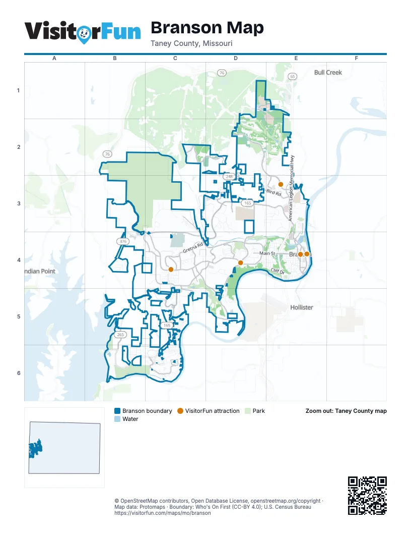
Street index of Branson
Each street on the sheet and the grid squares it crosses.
- American Legion Memorial HighwayE2, E3, E4
- West 76 Country BoulevardB4, C4, D4
- West Main StreetD4, E4
- South Business 65E4
- Taneycomo BridgeE4
- Shepherd of the Hills ExpresswayC3, D3, E3, C4
- Gretna RoadD3, C4, D4
- Branson Hills ParkwayD2, E2, E3
- Fall Creek RoadD4, C5, D5
- Roark Valley RoadC4, D4
- Branson Landing BoulevardE3, E4
- James F Epps RoadD3, D4
- State Highway 265B5, B6
- Veterans BoulevardE4
- Bee Creek RoadE3
- East Main StreetE4
- Green Mountain DriveB4, C4, D4
- Bird RoadD2, D3, E3
- Pointe Royale DriveC6
- Falls ParkwayC5
- Buchanan RoadD1, E1
- Branson Commerce ParkwayC2, D2
- Wintergreen RoadE2, E3
- Wildwood Drive SouthC4, D4, D5
- Park BoulevardC2
- Roark Valley DriveC3, C4
- Sycamore Church RoadC2
- Forsythe StreetD4
- Expressway LaneC3, D3
- Parnell DriveE3, E4
- Truman DriveD4
- South Falls AvenueC5
- Spring Creek RoadC5
- North Wildwood DriveC4
- Town Center DriveE3
- Francis StreetC4
- Keeter StreetC4
- Glory DriveC4
- Rosalee StreetC4
- Wildwood Drive NorthC4
- Branson Meadows DriveD3
- Buena Vista RoadD2
- Ledbetter DriveD3
- Dakota RoadC5
- SummitC4, C5
- East Long StreetE4
- North Commercial StreetE4
- South Commercial StreetE4
- Commercial StreetE4
- Animal Safari RoadB5, C5
- Quebec DriveC6
- Commerce WayD2
- Flynn RoadD2
- LedbetterD3
- Pinehurst DriveD2, E2
- Fall Creek DriveC5, C6
- Cliff DriveD4, E4
- Royal Dornoch DriveD2, E2
- Pat Nash DriveC4
- Promised Land Drive-Through Safari RoadC4
- Promised Land Zoo Drive-Through Safari RoadC4
- Vineyards ParkwayB4
- Treasure Lake DriveC3
- Champagne BoulevardC6
- Cedar Ridge DriveD3
- Pebble Beach DriveD1, D2
- Town & Country DriveD3
- Cahill RoadE3, E4
- Frank Rea BoulevardD4
- Sight and Sound DriveC3, D3
- Golf View DriveC5, D5
- Westwood DriveD3, D4
- Skyview DriveB5, B6
- Factory Merchants OutletsC4
- Little Pete RoadC4
- Caudill WayD4, D5
- Blue Meadows RoadC5
- Neihardt AvenueD4
- Fall Creek TrailC6
- Palmer DriveD2
- Schaefer DriveB4, C4
- Shady DriveC5
- Country Ridge WayC2
- Oak Ridge RoadC4
- Country Bluff DriveD5
- Waterfall RoadC3
- Summerwood DriveD3, D4
- Avondale DriveB6, C6
- Belladonna TrailB6
- Hatchery RoadB6
- South 3rd StreetE4
- Van Buren RoadC5, C6
- South DriveE3
- West Atlantic StreetE4
- Buccaneer BoulevardE3
- Sunset RoadE4
- Bass Pro DriveE4
- Branson Commerce LoopC2, D2
- Oak Creek DriveC4, D4
- Stockstill LaneD4, E4
- West Pacific StreetE4
- Ridge RoadC3
- Macbeth AvenueD4, D5
- Lake DriveE4
- Mulligan CourtD2, E2
- Kirkland DriveB4
- Oakmont CircleE2
- Stone Ridge DriveD3, E3
- South 5th StreetE4
- Berry DriveD4
- West College StreetE4
- Siena BoulevardE2
- Eiserman AvenueE3, E4
- South 2nd StreetE4
- South Sycamore StreetE4
- Sapling DriveD3
- Ozark Scenic DriveE2, E3
- Baylor LaneB6
- Lakefront DriveB5
- South 6th StreetE4
- Surrey BoulevardC4
- River DriveD5
- Miller DriveD4
- Winged Foot DriveD1
- Judy StreetC4
- Loggers RunC3
- West Maddux StreetE4
- Prairie Dunes DriveD2, E2
- Abby LaneC5, C6
- Hunter AvenueC5
- Elizabeth DriveB6
- Dalton DriveC5
- Pinkley DriveD3
- Wilshire DriveE4
- South Old Country RoadD4
- Plaza DriveB6
- Grand AvenueB6
- River LaneD5
- Tanger BoulevardC4
- Lopez LoopC2
- Meadow RidgeC6
- Sherry LaneB6
- East End RoadE3
- Shinnecock Hill DriveD2
- Valley View DriveE4
- Walnut LaneE4
- West Oklahoma StreetE4
- Spyglass DriveD2
- West Hensley StreetE4
- Payne Stewart DriveD2, E2
- Wimbledon DriveC6
- Lee AvenueD4, E4
- Fagan DriveE3
- Dandy WayD5
- Cooper Creek RoadD5
- The GreensC4
- Pavilion RoadC3
- Aaron WayC4
- Cottonwood CircleD3
- Dawn RoadD3
- Welk Resort CircleB6, C6
- Terrace RoadC6
- Treasure Lake RoadC3, C4
- Golfshores DriveC6
- West Highland StreetD4, E4
- Stillwood DriveD2, D3
- Yellow Ribbon AvenueC5
- Roark AvenueE4
- Timberlane DriveD2
- Doctor Good DriveD4
- Deauville CircleD3
- Pine StreetC4
- Ivy LaneD3
- Lakefront RoadD5
- Grand Summit PointE3
- Sherwood DriveC6
- Grand Country SquareD4
- North Sunshine StreetE4
- Luster DriveB6
- Scott BoulevardD4
- Michel LaneE4
- Roark Hills DriveD3, D4
- Willow BendC6
- Briarcliff RoadD3, E3
- Vixen CircleD3, E3
- Royal Oak DriveC3
- Bayhill CourtD2
- Bramble LaneC5
- Jury LaneC2
- Loganberry RoadD5
- Mockingbird LaneE4
- South 4th StreetE4
- ParkB4, C4
- Gateway DriveE3
- Rue de Villas CircleD3, E3
- West Long StreetE4
- Woodleigh RoadE3
- Hamlet RoadE3
- Harmony LaneC5
- Arlene StreetC4
- South Sunshine StreetE4
- Riverstone DriveE3
- Tyler StreetD4, E4
- Rose O'Neill DriveD4
- Springcreek CourtC5
- Chateau Cove DriveB5
- Upper Z LoopC3
- West Adams StreetE4
- Troon CircleE2
- Commerce DriveD3, E3
- Compton DriveE3
- Sunshine CircleC6
- Buckingham DriveC6
- Lakewood DriveE3
- Rockridge RoadD2
- Redwine CircleC2
- Preserve DriveC4
- Cardinal WayD3
- Lancashire DriveC6
- Boswell AvenueD4
- Turnberry DriveC6
- Beth Page CourtE2
- Blue Bird LaneC6
- Meadow AvenueC5
- Olympic DriveD2
- Anglers Pointe DriveC5
- Hero DriveD4
- Parunglo DriveC5
- Lakehills DriveE2, D3, E3
- Garner DriveD5
- Ellison StreetE4
- Enterprise LaneB6
- West Cedar StreetC4
- Anne LaneB4
- Deer Valley DriveD4
- Watermill LaneC5, C6
- Log Cabin CircleC4
- Eden WayB6
- Hideaway StreetD4, E4
- Saint Andrews StreetD2
- Spurlock DriveC6
- Royalty LaneC6
- Branson City ParkE4
- Shawnee AvenueD4, E4
- Harvey LaneC4
- Brown StreetE4
- Old State Highway 76B2
- Pirate DriveD3
- South SunshineE4
- Herschend LaneD4
- Cummings DriveD4
- Vaughn RoadE4
- Roark RoadE4
- Pocahontas StreetE4
- Colonial DriveD4
- Hummingbird LaneD3
- Monarch DriveC6
- Clubhouse DriveC6
- Norwood DriveC6
- Oxford DriveC5
- Jess-Jo ParkwayC4
- Noland RoadB2
- Rock Candy LaneC4
- Austin AvenueB6
- Rose O'Neill StreetD4
- Illinois StreetC5
- Whispering Oaks LaneD3
- Turtle Creek DriveD2
- Aberdeen LaneD5
- Skaggs RoadE4
- Trout BoulevardD5
- Memory LaneC6
- Harbour Town DriveD2
- Oak LaneE4
- Oak CourtE3
- Crosby StreetD4
- River Bend RoadD5
- Scenic CourtC6
- State Highway 165 Large LoopC5
- Fairfield DriveC6
- Corbin WayD5
- Lower Z LoopC3
- Woodland Acres RoadC4
- Summit ParkwayE3
- Eagle Pointe DriveC6
- Water MillB6, C6
- Woodridge DriveD3, E3
- Blacker StreetD4
- Violyn DriveD3
- Lagoon DriveE3
- Middletown RoadC4
- Nature TrailC3
- New Barry RoadB6
- Blue Sky DriveC2
- Estate CircleC6
- Stanley AvenueD4
- Celtic DriveD5
- Keystone RoadD3
- Ashbrooke DriveD3
- Outer RoadE3
Things to do on the Branson map
Places on the map
- 417 Vintage Market
- 76 Express
- Aldi
- Alexander Park
- Almost Home Lodge
- Aloha River
- Americas Best Value Inn
- Amish Country Store
- Andy Williams' Moon River Theatre
- Apple Tree Plaza
- Branson Hills Golf Club
- Branson Lakeside RV Park
- Branson Landing
- Branson Mall
- Branson Musicland Kampground
- Branson RecPlex
- Branson's Promised Land Zoo
- Cox Medical Center Branson
- Eiserman Street Park
- Go Karts
- Lakeside Forest Wilderness Area
- Library Center of the Ozarks
- Moonshine Beach Park
- Murphy Park
- Roark Vacation Resort
- Ruth and Paul Henning Conservation Area
- Shepherd of the Hills Fish Hatchery
- Silver Dollar City's WhiteWater
- Stockstill Park
- Sunset Park
- Sunset Park Trail
- Tanger Factory Outlet Center
- The Grand Village Shops
- The Shoppes at Branson Hills
- The Shoppes at Branson Meadows
- The Track Family Fun Parks
- Thousand Hills Golf Resort
- Treasure Lake RV Resort
- Walmart Supercenter
- White River Balds Natural Area
Next to Branson
- Bull Creek
- Hollister
- Indian Point
© OpenStreetMap contributors, Open Database License, openstreetmap.org/copyright · Map data: Protomaps · Boundary: Who's On First (CC-BY 4.0); U.S. Census Bureau















