

Missouri map
Southwest Missouri map
The sheet's index lists 20 highways; I-49, US 71 and US 60 cross the most grid squares. Things to do inside the boundary: Bass Pro Shops Outdoor World, Big Cedar Lodge and Big Sugar Creek State Park. Also on it: Ash Grove, Aurora and Ava.
Open the map (PDF, US Letter)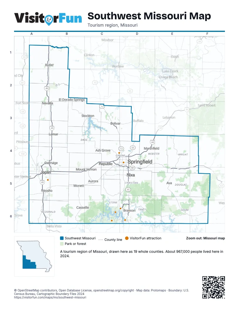
Highway index of Southwest Missouri
Each highway on the sheet and the grid squares it crosses.
- I-44A5, B5, C4, C5, D4, E4
- I-49A1, A2, A3, A4, A5, A6, B3, B4, B5
- US 60C4, D4, D5, E4, E5, F4, F5
- US 65D4, D5, D6
- US 71A1, A2, A3, A4, A5, A6, B3, B4, B5
- US 160C4, D4
- US 166A5
- US 400A5
- MO 5E5
- MO 13C3, C4, D4
- MO 43A5
- MO 52A1
- MO 59B5
- MO 76D6
- MO 96A4
- MO 171A4
- MO 176D5
- MO 215C4
- MO 249A4, A5
- MO 360C4
Things to do on the Southwest Missouri map
- Bass Pro Shops Outdoor World
- Big Cedar Lodge
- Big Sugar Creek State Park
- Bigfoot Fun Park
- Branson Landing
- Dogwood Canyon Nature Park
- Fantastic Caverns
- Fritz's Adventure
- George Washington Carver National Monument
- Roaring River State Park
- Silver Dollar City
- Table Rock Lake
- Table Rock State Park
- Titanic Museum Attraction (Branson)
- Wilson's Creek National Battlefield
- Wonders of Wildlife National Museum & Aquarium
Places on the map
- Ash Grove
- Aurora
- Ava
- Bolivar
- Branson
- Butler
- Carthage
- Cassville
- El Dorado Springs
- Joplin
- Lamar
- Marshfield
- Monett
- Mount Vernon
- Neosho
- Nevada
- Nixa
- Republic
- Springfield
- Stockton
Next to Southwest Missouri
- Arkansas Ozarks
- Northeast Kansas
- Southeast Kansas
- Central Missouri map
- Northwest Missouri map
- Southeast Missouri map
- Green Country
© OpenStreetMap contributors, Open Database License, openstreetmap.org/copyright · Map data: Protomaps · Boundary: U.S. Census Bureau, Cartographic Boundary Files 2024