

Missouri map
Farmington map
About 19,165 people live here (Census Bureau, 2024 estimate). The sheet's index lists 300 streets; West Columbia Street, Maple Street and New Perrine Road cross the most grid squares. Also on it: Farmington Regional Airport, Crown Pointe Golf Club and Engler Park.
Open the map (PDF, US Letter)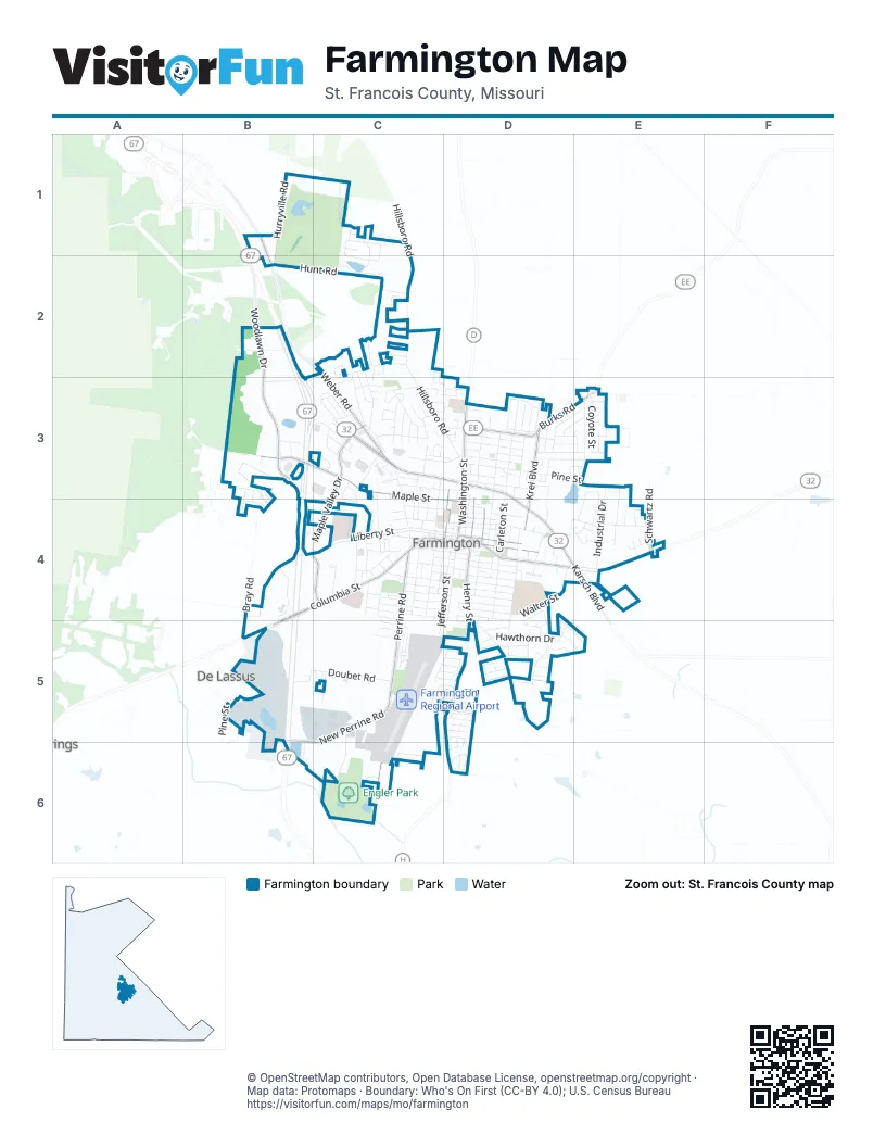
Street index of Farmington
Each street on the sheet and the grid squares it crosses.
- West Liberty StreetB4, C4, D4
- West Karsch BoulevardC3, D3
- East Karsch BoulevardD3, D4, E4
- West Columbia StreetB4, C4, D4, B5
- Maple Valley DriveC3, C4
- Sainte Genevieve AvenueD4, E4
- East Columbia StreetD4
- East Liberty StreetD4
- North Franklin StreetD3, D4
- Westmount DriveB4, C4
- North Main StreetD4
- Maple StreetB3, C3, C4, D4
- Perrine RoadC4, C5, C6
- Woodlawn DriveB2, B3
- North Washington StreetD3, D4
- Burks RoadD3, E3
- New Perrine RoadB5, C5, B6, C6
- Weber RoadC2, C3
- Krei BoulevardD3, D4
- South Henry StreetD4, D5
- Flat River RoadB1, B2
- North Henry StreetD3, D4
- Karsch BoulevardE4
- Hillsboro RoadC1, C2, C3, D3
- Pine StreetC3, D3, E3, B5
- Hunt RoadB2, C2
- Doubet RoadB5, C5
- Spring Brook Park DriveD4, D5
- Walter StreetD4
- North Middle StreetD3, D4
- North Carleton StreetD3, D4
- South Fleming StreetD4, D5
- Oak StreetD3, E3
- Bray RoadB3, B4, B5
- Progress DriveB5
- South Jefferson StreetC4, D4, C5
- Hurryville RoadB1, B2
- Forster StreetD4
- Potosi StreetC2, C3
- Air Park DriveB5, C5, C6
- East College StreetD4
- Industrial DriveE3, E4
- Aldergate StreetC4, D4
- South Washington StreetD4
- Wallace RoadC2, C3
- South A StreetC4
- Overall RoadB5
- Lakeview DriveE3, E4
- Valley Brook DriveD5, E5
- Boyce StreetC4, D4
- South Carleton StreetD4
- Stonegate StreetE3
- West College StreetC4, D4
- Hawthorn DriveD5
- Taylor AvenueC4
- Old Fredericktown RoadD5
- North StreetC3, D3
- John David DriveD3, E3
- Walker DriveB4, B5
- Market StreetC3
- Morris StreetD3
- North Potosi StreetC3, C4
- Treeline DriveD5
- Old Jackson RoadE4
- Carter StreetD4
- Park StreetD4
- West 6th StreetC4, D4
- North A StreetC3, C4
- Stono Mountain DriveC5, D5
- Hickory StreetD3
- Timberline DriveE3, E4
- Trimfoot TerraceD3
- Green Briar DriveC1, C2
- Michigan StreetD3
- Ann StreetD3, E3
- Hyler DriveC4
- West 2nd StreetC4, D4
- Burkstone DriveD3, E3
- South Franklin StreetC4, D4
- Butterfield DriveC2, C3, D3
- Coyote StreetE3
- Sun Valley DriveC3
- Grand Canyon DriveC3
- Hilltop Place DriveD5
- Lake Forest DriveC1, C2
- Roper LoopC5, D5
- Black Knight DriveC4
- Eastland DriveE4
- Vargo RoadB6, C6
- Overton StreetD4
- 7th StreetC4, D4
- Cherry Creek LaneD6
- Smith StreetD4
- North Jackson StreetD3, D4
- Center StreetC3, C4
- Pimville RoadB4
- South Main StreetD4
- Yellowstone DriveC3
- Airline DriveD4
- Edward StreetD4
- Doss StreetC4, D4
- West 1st StreetC4, D4
- Kinley DriveC4
- East Spring StreetD4
- Warren StreetD4
- Westmeyer RoadD5
- Black Oak DriveB3, B4
- Holly Tree RoadB2
- Fredericktown AvenueD4, D5
- Spruce StreetD3
- North Alexander StreetC3, C4
- Schwartz RoadE4
- Walton DriveC3
- Dewey AvenueC4
- North Jefferson StreetD3, D4
- Cayce StreetC4
- Veterans DriveD4
- Murphys WayC2, C3
- Louise StreetD4, D5
- South Long AvenueD4
- Ashbrook DriveC2, C3
- East 1st StreetD4
- Moore AvenueD3
- Saint Andrews DriveC1
- Hawk Hollow RoadB3
- Walmart DriveC3
- 3rd StreetC4, D4
- Saint Francois AvenueD4, E4
- Quarry StreetD4
- Cimarron CircleC3
- Green Trail DriveC1
- Yale AvenueC4
- Bell Mountain DriveC5, D5
- Patterson StreetD4
- Shenandoah DriveC3
- East Hillside DriveD3
- Maple Ridge RoadC3, C4
- Meadowbrook DriveD3
- Wabash AvenueD4, E4
- West Harrison StreetC4, D4
- Valley Creek DriveC3
- Pullan RoadC5
- Glenda DriveD5
- Vernon AvenueC4
- Hollyhock LaneC3
- Janey StreetC3
- C StreetC3, C4
- Parkland DriveC4
- Shade Tree LaneB3, B4
- Colorado StreetD3
- South Westmount DriveB5, C5, C6
- Hector DriveC5
- Redwood DriveC3
- Black RockD5, D6
- Camillia StreetD3
- Vandergriff StreetC3
- Woodgate StreetD3, E3
- Gendale StreetD3
- Keisha LaneE3
- Lisa DriveD5
- Laura StreetC4
- Pell StreetC4, D4
- 4th StreetC4, D4, B5
- Mileva CourtD4, D5
- Copenhagen RoadD6
- Roseland CourtC3
- Valley DriveD3
- Janey DriveC3
- Dawn StreetD5
- Vierse DriveD4
- Meramec DriveD4, E4
- Kingsway DriveD3
- Wellington PlaceC3
- Bayberry LaneC3, D3
- Log Cabin LaneC3
- Windsor LaneD3
- Heritage Meadows DriveD3
- Kenwood StreetD3
- Korber RoadC6
- Lakeshore DriveD3
- San Jewell DriveC2, B3, C3
- Ava CourtD4
- Hazel LaneB4, C4
- Icon WayD5
- Judy DriveC3
- Moore StreetD3
- Lee DriveC3
- Summit DriveD3
- Delassus RoadB5
- Lorraine StreetD5
- Willow Creek DriveC3, C4
- Haw StreetC4
- Autumn ChaseD5, D6
- Barclay DriveD5
- Oak Knoll DriveB4
- Mary RoadC2
- East Harrison StreetD4
- Dogwood LaneD3, E3
- Dorothy StreetD3, E3
- Sunset DriveC3
- Boulder Ridge DriveD5
- Branning DriveD5
- Blair StreetC5
- FoxgloveE3
- Joyce DriveC3
- Sumter DriveD5
- Wesley DriveC4
- Kimberly CourtC4
- Chestnut CourtD5
- Ozark DriveC3, B5, B6
- Arrowhead LaneE3
- Robby LaneD3
- Chadwick CourtD4
- West StreetC3, C4
- Electric StreetC3
- Squaw Valley DriveC3
- Hillside DriveD3
- Moss LaneB3, B4
- Doubet LaneC5
- Fox Glen DriveE3
- Valley View CourtE4
- Kansas AvenueD3, D4
- Loretta CourtD3
- Denman RoadC4
- Memorial PlaceC3
- Bucking Horse DriveD5
- McCormick DriveD3
- Edna DriveC3
- North Westwood DriveC3, D3
- Willow Brook DriveD5, E5
- East Lark CircleC5
- Sequoia CourtC3
- Dismuke DriveB5
- West Pine StreetC3
- Chadwell DriveC2
- Landrum DriveB5
- West Lark CircleC5
- North Fleming AvenueD4
- Huntleigh CourtC5
- Unid Road Farmington WestC3
- Addie DriveD5
- Callahan WayC5, D5
- Isabella CourtE3
- South Alexander StreetC4
- Yosemite CourtC3
- Detring LaneC5, D5
- Mc Cormick StreetC4
- Doris DriveC3
- Bent CreekC2
- Everglades DriveC3
- Vandiver CourtC3
- Cherry Hills DriveD5
- Rosebud LaneD3, E3
- Abbey LaneD5
- Robin CircleC5
- Showplace DriveB2
- Red Bud DriveE4
- Walnut Ridge RoadC3, D3
- Shepherd Mountain RoadC5, D5
- Maple Heights DriveB3
- Evergreen LaneE4
- North Long AvenueD4
- Harvey CourtC3
- Woodchase AvenueD3
- Harlan StreetD4
- Buford Mountain RoadC5, D5
- Nelson StreetD4
- Helber DriveD4
- Buck Mountain DriveD5
- Greenbrair LaneC1
- South Westwood DriveC3, D3
- Bell DriveD3
- Westmoor DriveC4
- Summerlin DriveC2, C3
- Tower AvenueD3
- Dale DriveD3
- Wrigley DriveC5, D5
- Norsewood PlaceC3, D3
- Sunshine LaneC5
- Holiday Park DriveC3
- Walnut StreetC4
- Sapling CourtB3
- Deerfield LaneE3
- Healy StreetD3
- Virginia StreetC4
- Blossom Hill LaneD6
- East Green Tree LaneC3
- Saint Albans DriveC1
- Grey FoxE3
- Ralph Pingel LaneC5
- Colony Church RoadE3
- Westgate DriveC4
- Mc Ilvane StreetD4
- Bailey StreetD4
- West Green Tree LaneC3
- Tanglewood CourtC4
- Butterfield Village LaneC3
- Stam StreetC4
- Woodland TrailB3
- West Spring StreetD4
Places on the map
- AMC Classic Farmington 4
- Applebee's
- Asher Lake
- Baymont Inn and Suites by Wyndham
- Burger King
- Crown Pointe Golf Club
- Crown Pointe Lodge BW Signature Collection
- Culver's
- Dean Danieley Park
- DQ Grill & Chill
- Elks Ballfield
- Engler Park
- Farmington City Hall
- Farmington Civic Center
- Farmington Dog Park
- Farmington Post Office
- Farmington Public Library
- Farmington Regional Airport
- Hager Lake
- Hampton Inn Farmington
- Harlan Park
- Holiday Inn Express & Suites Farmington
- Jefferson Elementary School
- KFC
- KREI Field
- Long Memorial Park
- Maple Valley Plaza
- McDonald's
- O-SAKI Express
- Panera Bread
- Parkland Health Center - Farmington
- Parkland Health Center Heliport
- Qdoba
- Quality Inn Farmington
- Richardson Field
- Roosevelt Elementary School
- Saint Francois County Court House
- Saint Francois County Sheriff's Department
- Walmart Supercenter
- Wilson Rozier Park
Next to Farmington
- De Lassus
© OpenStreetMap contributors, Open Database License, openstreetmap.org/copyright · Map data: Protomaps · Boundary: Who's On First (CC-BY 4.0); U.S. Census Bureau















