

Missouri map
Gasconade County map
About 14,655 people live here (Census Bureau, 2024 estimate). The sheet's index lists 300 streets; Oak Street, Little Bay Road and Brinkman Road cross the most grid squares. Things to do inside the boundary: Adam Puchta Winery, Hermann Visitor Information Center and Hermann Wine Trail.
Open the map (PDF, US Letter)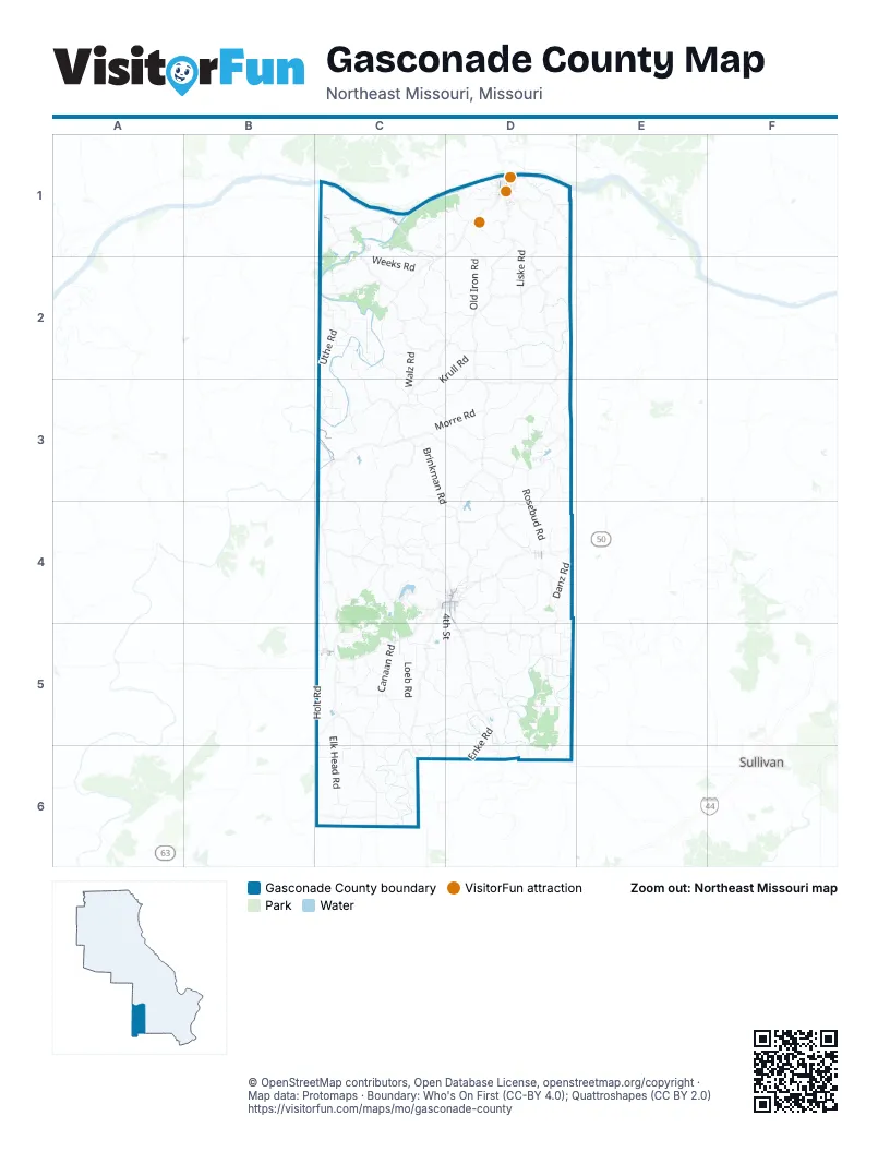
Street index of Gasconade County
Each street on the sheet and the grid squares it crosses.
- River RoadC2, C3
- Market StreetD1
- East 1st StreetD1
- East Lincoln AvenueD4
- South Olive StreetD4
- West Lincoln AvenueC4, D4
- South Cuba StreetD4, D5
- Oak StreetC1, D4, C5
- Springfield RoadD4
- Goethe StreetD1
- Marvin AvenueD4, C5
- Colorado AvenueC5
- Lyford StreetC5
- 14th StreetD1
- 3rd StreetC1, D4
- South 7th StreetC4
- Elk Head RoadC5, C6
- Old Ferry RoadC2
- First Creek RoadC2, D2
- Rosebud RoadD3, D4
- Hog Trough RoadD5, D6
- Drake School RoadD3
- Old Iron RoadD1, D2
- Coles Creek RoadC1, D1
- Little Bay RoadD2, C3, D3
- Loeb RoadC5
- Brinkman RoadC3, C4, D4
- Krull RoadC2, D2, C3
- Mount Sterling RoadC3, C4
- Clifty RoadD2
- Holt RoadC5
- Lahmeyer RoadC4, C5
- Pump Station RoadD4, D5
- Weeks RoadC2
- Stony Hill RoadD2, D3
- Horstman RoadD2
- Klott RoadC2, D2
- Hecker RoadC5, D5
- Lone Grove School RoadD3
- Brick Church RoadC4
- Old State RoadD3
- Rehmert RoadC4, C5
- Glaser Hollow RoadC5, C6
- Krausetown RoadD4
- Boettcher RoadC4
- Danz RoadD4
- Bickmeyer RoadC2
- Koenig RoadC5, D5, D6
- Kings HighwayC3
- Liske RoadD1, D2
- Durbin RoadC5, C6
- Enke RoadD5, D6
- Old Woolam RoadC4, D4
- Kattlemann RoadD2, D3
- Tschappler RoadC4, D4
- Morre RoadC3, D3
- Canaan RoadC5
- Bem Church RoadC5, D5
- Gorrel RoadC6
- Steinbeck RoadD3
- Mud Creek RoadC3
- Helds Island RoadC2, C3
- Republican RoadC5
- Piezuch RoadD4
- Bohl RoadC2, D2
- Peterson RoadC5, C6
- Brown Shanty RoadC2, C3
- Niewald RoadD4
- Licklider RoadD5, D6
- Sand Plant RoadD1
- Rohlfing RoadD1
- Estes RoadD4
- Kohrman RoadC4
- Mount Pleasant RoadC6
- Uthe RoadC2
- Bohemian HighwayD5
- Block Branch RoadD5
- Kuhne RoadC4
- Pigg Hollow RoadC3, D3, C4
- Walz RoadC2, C3
- Frene Creek RoadD1
- Kramme RoadD5
- Stolpe RoadC1, C2
- County Line RoadD3, D4
- Juedeman RoadD5
- Cedar Branch RoadC4
- Cross Road Church RoadC5
- Holzschuh RoadC4, C5
- Roethemeyer RoadD4
- 4th StreetC1, D4, D5
- Fowler RoadC3
- Cleavesville RoadC5
- Diebal RoadD2
- Homeyer RoadD5
- Wurtz RoadD2
- Krause RoadC5
- Brandhorst RoadD3
- Barren Fork RoadD3
- Brakemeyer RoadD3
- Strassner RoadD2
- Pfeiffer RoadD3, D4
- Price RoadC5, D5
- Swiss Lake RoadD2, D3
- Tea RoadD5
- Farris RoadC5
- Tappmeyer RoadD4, D5
- Boy Scout RoadD1
- Ocean Wave RoadD3
- Wild Cat RoadC5
- Doll RoadD2
- Stronghoener RoadD3
- Lip-A-Tal RoadC1, D1
- Morrison Bottom RoadC1
- Helmig Ferry RoadC3
- Benson RoadC2
- Bomback RoadD5
- Michel RoadC4, D4
- Souders RoadD5, D6
- St Paul Ch RoadC3, D3
- Red Bird RoadC6
- Schneider RoadC6
- Pleasant Hill School RoadD3
- Bareis RoadD1
- Blocks Branch RoadD5
- Miller DriveC5, D5
- Lake Shore DriveC4
- Catholic Church RoadD2
- Ruegge RoadD4
- Wehmeyer RoadD4
- Pershing RoadC2
- Blue House RoadD5
- Meyer RoadC4, C5
- Thenhaus RoadD5
- Hamilton RoadD5
- Fischer RoadD5
- Van Deven RoadD5, D6
- Lake RoadC4
- Lake Timber Ridge RoadC3
- Idel RoadD4
- Good Hope RoadD2
- Epple RoadD1, D2
- Bohrenpohl RoadC4
- South 4th StreetD4, D5
- Huebner RoadD5
- Shoemaker RoadD5, D6
- Baxter RoadC6
- Jett RoadC5
- Scheel RoadC4
- Mint Spring RoadC6
- Stolpe Bottom RoadC2
- Wandersee RoadD5
- Grannemann RoadD3
- Shockley RoadC4
- Gaddy RoadD5
- Zastrow RoadC2
- Hollandsworth RoadD4
- Shady LaneD2
- Epple-Fricke DriveD1
- Erv Hans DriveC2
- Cave Hill RoadC3
- Sawmill RoadD1
- Main StreetC1, C5
- 2nd StreetC1, C2, D4
- Schaefferkoetter RoadD5
- Norton RoadD1
- Zumsteg RoadC1
- Ellis Farm LaneC3
- Jost RoadD5
- Patterson RoadC4
- Dittman RoadC5
- Winter RoadD3
- Peaceful Valley RoadC4
- Hempelmann RoadD4, D5
- Simpson RoadD6
- Kleagler RoadD5
- Oak Forest RoadC6
- River Bend LaneC6
- Schlottog RoadC4
- Eikermann RoadC2
- Crows Holler RoadC3
- Herbert RoadD5
- Stollmeyer RoadC2
- Lovers LaneD1
- Widemann School RoadC2, C3
- Dead End RoadD4
- Charlotte Church RoadD3
- Branch RoadD1, C5, D5
- Old Highway 19D4
- Schwegler RoadC3
- Peth RoadC4
- Bowen Cemetery RoadC6
- Zero RoadD1
- Rutz RoadD5
- Church RoadC5, D5
- Brandenburger RoadD6
- Spurgeon RoadC5
- Berkemeyer RoadD2
- Fritsch LaneD4
- Tall Oaks DriveC5
- Cedar LaneD1
- Van Horn RoadC6
- Woodson DriveC4
- Apache TrailC1, D3
- Ruskaup RoadC3
- 1st StreetC1, D4
- Villa Vista DriveC4
- Washington StreetD1
- Teckmeier RoadC1
- South 2nd StreetD4
- Gutenberg StreetD1
- Bottom RoadC2
- Tower Grove RoadD5
- Stockpile RoadD4
- Jefferson StreetD1
- Wink RoadC1
- Moccasin TrailC1
- Hickory Lake RoadD5
- Beul Store RoadC2
- Trainer RoadC6
- Baker RoadD4
- Red Oak RoadD4
- Aufderheide RoadD3
- Old Farm RoadD5
- Mozart StreetD1
- Luhring LaneD5
- Broadtrick RoadD5
- Haines RoadC5
- West 4th StreetD1
- Piocyfk RoadD5
- Nursing Home RoadD4
- Carrol LaneC4
- West 6th StreetD1
- Garner RoadD2
- Pine StreetC1, D4
- Cleavesville Cem RoadC5
- Gerloff RoadC3
- Virgil Nicks RoadD4
- Koebel RoadC5
- Freckman RoadC1, C2
- Hafertafe RoadD4
- Bock RoadC4
- Fox TrailD3
- Little Berger RoadD2
- Lakeview DriveC5
- Schiller StreetD1
- Cedar StreetD4, C5
- West Jackson AvenueC4, D4
- Hoppe School RoadC2
- Koch RoadC4
- Ferd LaneC6
- Nowack RoadD4
- Presp Church RoadC3
- Hartshorn RoadC2
- Boston RoadD4
- North 2nd StreetD4
- Bucholz HollowC4, D4
- County Road 426C6
- Rosebud AvenueD4
- Smith RoadD4, D6
- Swain RoadC5
- County Road 427C6
- Woemmel RoadC5
- South Hickory StreetD4
- Lake Northwoods RoadD4
- West 8th StreetD1
- East Springfield RoadD4
- Nicks RoadD4
- Gellert StreetD1
- Industrial DriveD1, D4
- Belaire PlaceC2
- East Franklin AvenueD4
- Commercial DriveD4
- East Jefferson AvenueD4
- June DriveC5
- Parshell RoadD6
- East Madison AvenueD4
- River Valley LaneC3
- Circle DriveC4, D4
- Johns LaneC3
- Toad Hop RoadD1
- West 9th StreetD1
- Wildebrandt RoadD4
- Park DriveD4
- South Walnut StreetD4
- Hill Crest DriveD4
- East 12th StreetD1
- Debbie LaneC4, D4
- Liesemeyer RoadD3
- Old Zero RoadD1
- Sulpher Spring RoadC4
- Scego LaneD5
- Wein StreetD1
- East 6th StreetD1
- Rocky LaneC6
- Deer DriveD3
- Uncle Sam RoadC5
- Reserve StreetD1, D4
- South 1st StreetD4
- Bank StreetC1
- Fort Wilderness LoopD3
Things to do on the Gasconade County map
Places on the map
- Arthur Jasper Lake
- Bland
- Canaan Conservation Area
- Carawood Lake
- Cave Hill
- Cedar Hill
- Countryside Memorial Gardens
- Daizy Vally Reservoir
- Duck Luck Lake
- Eu-Wish Airport
- Fredericksburg Ferry Access
- Fritz Pueschel Lake
- Gasconade
- Gasconade Harbor Facility
- Godefroid Lake
- Hedenkamp Lake
- Hermann
- Hermann Area District Hospital
- Hermann Branch Library
- Hermann City Park
- Hermann Lumber Do-It Best
- Hickory Lake
- Homer Hensley Lake
- Lake Northwoods
- Lake Timber Ridge
- Memory Lake
- Miller Farm Airport
- Morrison
- Number 72 Reservoir
- Number 74 Lake
- Owensville
- Peaceful Valley Lake
- Pilot Knobs
- Rosebud
- Scenic Regional Library--Owensville Branch
- See Tal Lake
- Smith Hill
- Triple Lakes
- USP Office
- Walkenbach Lake North
Next to Gasconade County
- Sullivan
© OpenStreetMap contributors, Open Database License, openstreetmap.org/copyright · Map data: Protomaps · Boundary: Who's On First (CC-BY 4.0); Quattroshapes (CC BY 2.0)















