

Missouri map
Grain Valley map
About 16,859 people live here (Census Bureau, 2024 estimate). The sheet's index lists 300 streets; Southwest Eagles Parkway, North Main Street and East Duncan Road cross the most grid squares. Also on it: Cross Creek Park, East Kansas City Airport and Football Field Complex.
Open the map (PDF, US Letter)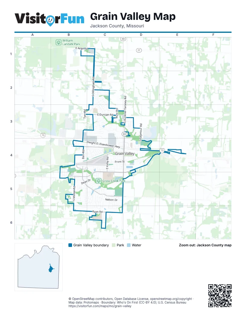
Street index of Grain Valley
Each street on the sheet and the grid squares it crosses.
- Dwight D. Eisenhower HighwayC4, D4
- North Main StreetD3, D4, D5
- Southwest Eagles ParkwayC4, B5, C5, D5
- East Duncan RoadB3, C3, D3
- Southwest Sni-A-Bar BoulevardB5, C5
- South Buckner Tarsney RoadD3, C5, D5
- East Old US Highway 40D4, E4, D5
- East R.D. Mize RoadB4, C4, C5
- South Minter RoadB5, B6
- Northwest Sni-A-Bar BoulevardB4, C4
- East Kirby RoadC4, C5
- West Ryan RoadC6
- Northwest Sni-A-Bar ParkwayB4, B5
- East Pink Hill RoadC2
- R.D. Mize RoadC4
- R D Mize RoadB4
- East Ryan RoadC6
- South Dillingham RoadC1, C2, C3
- Northwest Jefferson StreetB4, C4
- Northwest Hedgewood DriveC2, C3
- Foxtail DriveC5, B6, C6
- Valley SpeedwayD4
- Northeast McQuerry RoadC4, D4
- Nelson DriveC5
- Northwest Rosewood DriveC2, C3
- Grain Valley MXD4
- Cross Creek DriveC4, C5, C6
- Broadway StreetC4, D4
- Northwest Woodbury DriveC3
- Willow DriveB4, C4
- Lakeview DriveB5, C5
- East McQuerry RoadD4, E4
- Shorthorn DriveC5, C6
- Golfview DriveB4, C4
- Northwest Willow DriveB4, C4
- Northwest East Kansas City Industrial BoulevardB3, C3, C4
- South Outer Belt RoadD4
- Northwest Nicholas DriveC3
- South Rust RoadC3
- East Argo RoadB1, C1
- Woodbury DriveC3, D3
- Montana Ridge DriveB5
- Creek Ridge DriveC5, C6
- Northwest Sycamore DriveC2
- South Seymour RoadD3, D4
- Graystone DriveB5, C5
- Northwest Hilltop LaneB3, C3
- Northwest Long DriveB4, C4
- Northwest Burr Oak LaneC3
- West Front StreetC4, D4
- West Walnut StreetC4, D4
- Yennie AvenueC4, D4
- North Rust RoadC3
- Northwest Persimmon DriveC2, C3
- Barr RoadB4
- Northwest Lindenwood DriveC2
- Southwest Tisha LaneC5
- Northwest Pecan DriveC3
- Northwest Meadow RoadC4
- Whitestone DriveC5
- Northwest Scenic DriveB4, C4
- Brome DriveC5
- Valley Ridge DriveC3, C4
- Dean DriveB5, C5
- Blue Branch DriveB5, C5
- Cross CreekC6
- Sandy LaneC5
- Stonebrook LaneC5
- East Harris StreetD4
- James D Rollo DriveD4
- East Broadway StreetD4
- Northwest Cedar DriveC3
- Meadowood DriveC5
- Pond AvenueC3
- Northwest Eagle Ridge BoulevardB3, B4, C4
- Northeast Tyer RoadB3, B4
- Southwest Laura LaneC5
- Hillsboro DriveB5, C5
- Northwest Highway DriveC3
- Thieme StreetC4
- Cypress StreetD4
- Northeast Jaclyn DriveD3
- Southwest Gateway CourtC5
- Northwest Elmwood DriveC3
- Northwest JackieB4, B5
- Southwest Rock Creek LaneC5, D5
- Northwest Baytree DriveB4, C4
- GatewayC5
- Elizabeth StreetC4
- Northwest Broadway StreetB5
- Gregg StreetC4
- Kirby RoadC4
- Hereford DriveC5, C6
- Southwest Joseph CircleB5
- Southwest Lee Ann DriveC5, C6
- Ridgeview DriveC5, C6
- West Rust RoadC3, D3
- Northwest Sawgrass DriveB4, C4
- Ginger Hill DriveC5
- Valley Woods DriveC4
- Northeast Greystone BoulevardD3
- Northwest Hickorywood CourtC2
- Northwest Cedar LaneC3
- Southwest Graystone DriveC5
- Christie LaneC5
- Northwest Dogwood DriveC3
- Northwest Bailey DriveC3
- Ephraim DriveB5, C5
- Northwest Highview DriveB3, C3
- Northwest Par DriveC4
- Royer LaneC4, C5
- Charlotte StreetC4
- HarvestC5, C6
- Northwest Crestwood DriveC2
- Northwest Albatross DriveC4
- Northwest Chrisman Farm RoadC3, C4
- Addie LaneB5
- Northwest Whitny DriveC3
- Northwest Pamela BoulevardC3, C4
- Northwest WoodburyD3, D4
- North Garden StreetC4, C5
- Northwest MichaelB4, B5
- Northwest Eagle DriveC4
- Northwest LindseyB4, B5
- South Meadow LaneC3
- CrosscreekC5
- Northwest Scenic LaneB4
- Highland AvenueC5, C6
- Cross Creek LaneC5
- Northwest Nolad DriveC3
- Clover DriveC5
- Capelle StreetC4
- Foot Hills DriveB5
- Northeast Amanda Jean WayD3
- Blue RoadB5
- Northwest Green DriveC4
- Southwest Crestview DriveC5
- South StreetC4
- Northwest Eagle Ridge DriveB3, C3
- Rock Creek DriveC5
- Southwest Minter WayB5
- Country Hill DriveC5
- Joseph LaneB5
- Concord CircleC4
- Northwest Magnolia LaneC3
- South Tyer RoadB3
- Young StreetC4
- Hamilton LaneB5
- Northwest Redbud DriveC3
- Northwest BroadwayB5
- Northwest Cottonwood DriveC3
- Valley Woods CourtB4
- Northwest Minos DriveC3
- Muriel DC6
- Northwest Aspen CourtC3
- North Hannah CourtD3
- Northwest Megan DriveC2
- Valley Ridge CourtC4
- Stoneybrooke DriveB5
- Northwest Olympic DriveC4
- Tyer RoadB4
- Greystone DriveC5
- Sunny Lane DriveD4
- Barbara DriveC4
- Woodland DriveC5
- Stockman CourtB5, C5
- Parker DriveC4
- Westview DriveC5
- SunsetC5
- Garden StreetC5
- Northwest Whitney CourtC3
- Northwest Red Oak CourtC3
- Stoney Point DriveC6
- Northwest Cottonwood CircleC3
- Northwest Cottonwood CourtC3
- Valley DriveC4
- Cannon StreetC4, D4
- Northwest Phelps DriveC3, C4
- Northwest Rust CourtC3
- Abar DriveC5, C6
- Stonebrook DriveC5
- Harris StreetC4, D4
- Northwest Orion RoadC3
- Northwest Rymeg DriveC2
- Northwest Ashley LaneB4
- Northwest Hickorywood DriveC2
- Northeast Mary CourtD3
- Northwest Granite DriveC3, C4
- Smith StreetC4
- Southwest Country Hill DriveC5, C6
- Rockhill DriveC6
- Blue Branch CourtB5
- Nelson CourtC5
- Centurion CourtC5
- Northeast Coldwater DriveD4
- Northwest Ashley DriveB4
- Northwest Brentwood DriveC2
- East Front StreetD4
- Southwest AugustC5
- East Walnut StreetD4
- Pavilion DriveB4
- Northeast Erin CourtD3
- Northwest JeffersonC4
- Oak StreetC4, C5
- Northwest Hawthorn CourtC2
- North Cross Creek DriveC4
- Northeast Clear Creek DriveD4
- South Lefholz RoadE4
- Northwest Boxelder CourtC3
- Graystone CircleB5
- Northeast San Kar DriveD4
- Amanda LaneC4
- Mountain View CourtC5
- Northeast Deer Creek DriveD4
- Aaron LaneC4
- Oak Wood LaneB5
- Ooida DriveC4
- Stockman DriveC5
- Indian Creek DriveB5, C5
- Pebble Brook LaneC5
- Blue Ranch DriveB5
- Northwest Bush DriveC4
- NW Meadow RoadC4
- Rock Creek LaneC5
- Crestview CourtC5
- Valley Ridge CircleC3
- Northwest Birch CourtC3
- Northwest Hickory CourtC2, C3
- Northwest Maplewood CourtC3
- Northwest Poplar CourtC2, C3
- Northwest Walnut CourtC3
- Northeast Wolf Creek DriveD4
- PebblebrookC5
- Northwest Minter roadB5
- Minter AvenueC4
- Northeast Greystone WayD3
- Casey BoulevardC4
- Northwest Sycamore CourtC2
- Northwest Tayler CourtC3
- Squire CourtD4
- James D Rollo CourtD4
- Southwest Hill Top CourtC6
- Southwest Meadow GlenC6
- Phelps DriveC3, C4
- Southewest Apple Grove CourtC6
- Hampton CourtB5
- South Mill Creek CourtC6
- Northwest Mya CourtC3
- Woodland CircleC5
- Harvest CircleC5
- Southwest Orchard CourtC6
- Armstrong DriveD4
- Southwest Ridgeview DriveC5
- Lee Ann CircleC5
- Northwest Honeylocust CourtC3
- Northwest Sweetgum CourtC2
- Lois LaneC5
- Northwest Whispering CourtC3
- Meadow RoadC4
- Southwest Logan DriveC5
- Meadow LaneC4
- Northwest Creekland DriveB5
- 3rd StreetD4
- Northeast Katie CourtD3
- Northwest BasswoodC2
- Northwest Cedar CourtC3
- Dakota Star CourtB5
- Lonestar CourtB5
- Northeast Kim CourtD3
- Hillside CourtC5
- Northwest Short StreetC3
- Northwest Silverstone CircleC4
- Northwest Aspen DriveC3
- Northwest Pecan PlaceC3
- Northwest Meadow CourtC4
- Northwest HedgewoodC3
- Baytree CircleC4
- Northwest Mulberry CourtC3
- Northwest Madison CourtC3
- Northwest Cherry CourtC2
- CapelleC4
- Northwest Asbury CourtC3
- Indian Creek CourtB5
- Northwest Pin Oak CourtC3
- Southwest Addy LaneB5
- Northwest Catalpa CourtC2, C3
- Willow courtB4
- Front StreetC4
- Northwest Woodbury LaneC3
- Oak Wood CourtB5
- Ambush CourtC5
- Southwest Montana Ridge DriveB5
- Aaron CourtC4
- Clover CourtC5
- Golfview CourtB4
- Southwest Primrose CourtC5
- Washeam CourtC3
- Northwest Hackberry CourtC3
- Greystone CourtC5
- Northwest Azalea CircleC4
Places on the map
- Advance Auto Parts
- Americas Best Value Inn
- Amoco
- Armstrong Park
- B&B Grain Valley Marketplace 8 & GS
- Brass Armadillo Antique Mall
- Butterfly Park
- Captain's Sports Lounge
- Casey's General Store
- Club Car Wash
- Country Oak Village
- Cross Creek Park
- Crossroads Church
- Culver's
- Dental Care of Eagle Valley
- Dollar General
- Duncan Academy
- East Kansas City Airport
- Faith United Methodist
- Farmington Meadow Park
- Fire Station 6
- First Baptist Grain Valley
- Football Field Complex
- Grain Valley City Hall
- Grain Valley Community Center
- Grain Valley Community Garden
- Grain Valley Family Dental
- Grain Valley High School
- Grain Valley HS Football Field
- Grain Valley MX
- Grain Valley Police Department
- Matthews Elementary School
- McDonald's
- Mid Continent Public Library - Grain Valley
- Mid-Continent Public Library
- Mid-Continent Public Library - Grain Valley Branch
- MO Country
- O'Reilly Auto Parts
- Trailside RV Park & Propane
© OpenStreetMap contributors, Open Database License, openstreetmap.org/copyright · Map data: Protomaps · Boundary: Who's On First (CC-BY 4.0); U.S. Census Bureau















