

Missouri map
Northwest Missouri map
The sheet's index lists 38 highways; US 71, I-29 and I-35 cross the most grid squares. Things to do inside the boundary: Adam-ondi-Ahman, American Inn North Kansas City and American Jazz Museum. Also on it: Albany, Belton and Bethany.
Open the map (PDF, US Letter)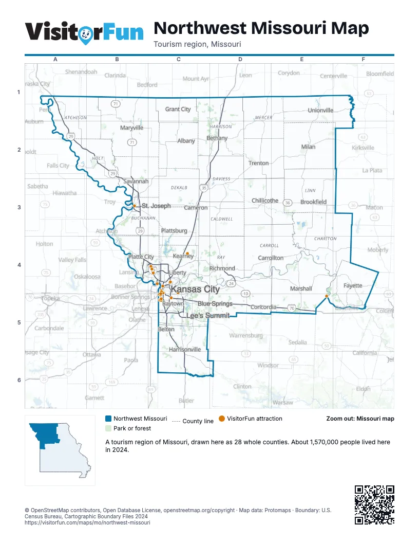
Highway index of Northwest Missouri
Each highway on the sheet and the grid squares it crosses.
- I-29A1, A2, B2, B3, B4, C4
- I-35C3, C4, C5, D1, D2
- I-49C5, C6
- I-70C4, C5, D5, E5
- I-229B3
- I-435B4, C4, C5
- I-470C5
- I-635C4
- I-670C4
- US 24C4, C5, D4
- US 36B3, C3, D3, E3, F3
- US 40C4, C5, D5, E5
- US 50C5
- US 56C5
- US 59B2, B3
- US 65D4, E4, E5
- US 69C4
- US 71B1, B2, B3, B4, C4, C5, C6
- US 136B1, B2
- US 169C4
- MO 2C5, C6
- MO 5E3
- MO 7C5, C6, D6
- MO 9C4
- MO 10C4, D4
- MO 13D4, D5
- MO 31C3
- MO 33C3
- MO 58C5
- MO 110C3, C4, D3, E3, F3
- MO 129E3, F3
- MO 139E3
- MO 150C5
- MO 152B4, C4
- MO 210C4
- MO 273B3
- MO 291C4, C5
- MO 350C5
Things to do on the Northwest Missouri map
- Adam-ondi-Ahman
- American Inn North Kansas City
- American Jazz Museum
- Ameristar Casino Hotel Kansas City
- Annie and Abel Van Meter State Park
- Arabia Steamboat Museum
- Argosy Casino Hotel & Spa
- Arrow Rock State Historic Site
- Arrowhead Stadium
- Arthur Bryant's Barbeque
- Best Western Plus Kansas City Airport-KCI East
- Boulevard Brewing Co. Tours & Rec Deck
- City Market
- College Basketball Experience
- Comfort Inn & Suites Kansas City - Northeast
- Country Club Plaza
- Crowder State Park
- Crown Center
- Drury Inn & Suites Kansas City Airport
- Glore Psychiatric Museum
- Harry S. Truman National Historic Site
- Harry S. Truman Presidential Library and Museum
- Jesse James Birthplace
- Jesse James Home Museum
- Just One Day Travel Tours
- Kansas City Helicopter Tours
- Kansas City Power & Light District
- Kansas City Zoo & Aquarium
- Kauffman Center for the Performing Arts
- Kauffman Stadium
- KC Streetcar
- KC Visitor Center
- Kemper Museum of Contemporary Art
- Kessler Park
- La Quinta Inn & Suites by Wyndham Kansas City Airport
- Legoland Discovery Center Kansas City
- Liberty Jail
- Loose Park
- Midwest Genealogy Center
- National Museum of Toys and Miniatures
- National WWI Museum and Memorial
- Negro Leagues Baseball Museum
- Nelson-Atkins Museum of Art
- Royals Hall of Fame
- Starlight Theatre
- TerraVox Winery
- The Money Museum at the Federal Reserve Bank of Kansas City
- Union Station Kansas City
- Wallace State Park
- Weston Bend State Park
- Worlds of Fun
Places on the map
- Albany
- Belton
- Bethany
- Blue Springs
- Brookfield
- Cameron
- Carrollton
- Chillicothe
- Concordia
- Fayette
- Grant City
- Harrisonville
- Kansas City
- Kearney
- Lee's Summit
- Liberty
- Marshall
- Maryville
- Milan
- Platte City
- Plattsburg
- Raytown
- Richmond
- Savannah
- St. Joseph
- Trenton
- Unionville
Next to Northwest Missouri
- Loess Hills and Beyond
- Storied and Scenic
- Northeast Kansas
- Central Missouri map
- Northeast Missouri map
- Southwest Missouri map
- Southeast Nebraska
© OpenStreetMap contributors, Open Database License, openstreetmap.org/copyright · Map data: Protomaps · Boundary: U.S. Census Bureau, Cartographic Boundary Files 2024