

Missouri map
Jefferson City map
About 42,564 people live here (Census Bureau, 2024 estimate). The sheet's index lists 300 streets; West Edgewood Drive, Rex M Whitton Expressway and Algoa Road cross the most grid squares. Things to do inside the boundary: Missouri Division of Tourism.
Open the map (PDF, US Letter)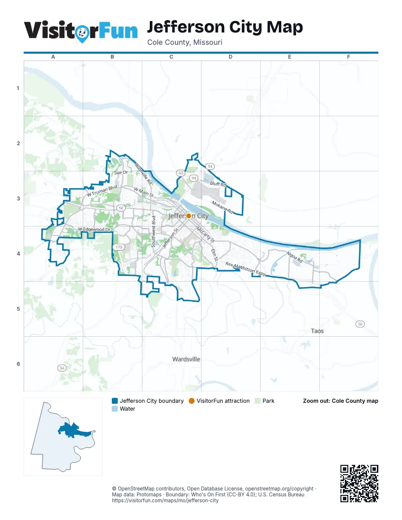
Street index of Jefferson City
Each street on the sheet and the grid squares it crosses.
- Rex M Whitton ExpresswayC3, C4, D4, E4
- C. F. “Red” Whaley ExpresswayC3, B4, C4
- Rock Hill RoadB2, B3
- Commerce DriveB3
- Hartsfield BoulevardB3, B4
- West Edgewood DriveA3, B3, A4, B4, C4
- Missouri BoulevardA3, B3, C3
- East McCarty StreetC3, C4, D4
- Algoa RoadD4, E4, F4, F5
- West Main StreetB3, C3
- Country Club DriveA3, B3
- Jefferson StreetC3, C4
- Industrial DriveB3, C3
- Stadium BoulevardB4, C4
- Tanner Bridge RoadC4, C5
- West Truman BoulevardA3, B3
- South Country Club DriveA3, A4
- Southwest BoulevardC3, C4
- West McCarty StreetC3
- Bluff RoadC3, D3
- Ellis BoulevardC4
- East High StreetC3, D4
- Eastland DriveD4
- Militia DriveE4, E5
- East Dunklin StreetC3, C4, D4
- Lafayette StreetC3, D3, C4
- Lorenzo Green DriveC4, C5
- West High StreetC3
- Madison StreetC3, C4
- Green Berry RoadC4
- Seven Hills RoadC4, D4
- West Stadium BoulevardB3, B4
- Broadway StreetC3
- Moreau DriveC4
- Leandra LaneA4
- Dix RoadC3
- Old Lohman RoadA3, A4
- Tomahawk RoadD4, E4
- Clark AvenueC4, D4
- West Dunklin StreetC3
- Christy DriveC4, C5
- Boonville RoadB2, C2, C3
- Southridge DriveB4, C4
- East Elm StreetC4, D4
- Bald Hill RoadC4, D4
- Wildwood DriveB3, B4
- East Capitol AvenueC3, D4
- Fairgrounds RoadA3, A4
- North Shamrock RoadE4
- Horner RoadA3
- Rock Ridge RoadA4, B4
- Stoneridge ParkwayB3
- Vieth DriveB4, C4
- Frog Hollow RoadB4
- Idlewood RoadB4
- Myrtle AvenueC3, C4
- Liberty RoadE4, E5
- Cedar City DriveC3
- Mission DriveB4
- Leslie BoulevardC4
- Bolivar StreetC3
- Linden DriveC3, C4
- Hard Rock DriveB3
- Satinwood DriveB4, C4
- Cavalier DriveB4
- Hyde Park RoadB3, C3
- Edgewood DriveC4
- West Capitol AvenueC3
- Scruggs Station RoadA4
- Scott Station RoadB3
- Heisinger RoadC3
- Kansas StreetC3
- Vetter LaneD4
- Airport RoadC3
- Creek Trail DriveB4
- County Park RoadA4
- Peyton DriveC4
- Rainbow DriveA3
- Wardsville RoadC4
- Schott RoadD4
- BroadwayC3
- Shamrock RoadE4
- Mokane RoadC3, D3
- East Miller StreetC3, C4, D4
- Chestnut StreetD3, C4
- Saint Marys BoulevardB3, C3
- Saint Louis RoadD4
- Monroe StreetC3, C4
- Green Meadow DriveC4, C5
- Oilwell RoadC2, C3
- Jackson StreetC3, C4
- Fence Line RoadE4, F4
- Adams StreetC3, C4
- Swifts HighwayC4
- East Wall WayC3, C4, D4
- South Ten Mile DriveB3
- Belair DriveB2, B3
- Turnberry DriveA3
- London WayA4
- Duane Swift ParkwayC4
- Sue DriveB3
- Riverside DriveD4
- Range RoadE4, F4
- Scenic DriveD4
- North Ten Mile DriveB3
- Stertzer RoadE4
- East Atchison StreetC4
- Hayselton DriveC3
- Gettysburg PlaceA3, B3
- MshpD4
- Hibernia RoadC3
- Bennet LaneC5
- Constitution DriveB3
- Buckingham ParkA4
- Clayton DriveC4
- Rolling Hills DriveB4
- Scarborough WayA4
- Norris DriveB3, C3
- Oxford RoadA4
- Veterans LaneC4
- Portabello Place DriveB4
- Hutton LaneD4
- Tower DriveC3, B4
- Washington StreetC3, C4
- Shawn DriveB2, B3
- Commercial AvenueC3, C4
- Landwenr Hills RoadD4
- West Miller StreetC3
- Aviarion DriveC3, D3
- Sandstone RoadC3
- Marshall StreetC3, C4
- Jennifer DriveD4
- Diamond RidgeB3, B4
- Nelson DriveD4
- Schumate Chapel RoadB3
- Morris DriveB2, B3
- Moreau River AccessE4
- Katy RoadC2, C3
- Robinson RoadD4, E4
- Military CircleE4
- Emerald LaneB4
- Cedar Hill RoadB4, C4
- Virginia TrailB3
- Whitney Woods DriveC4, C5
- Mohawk DriveD4, E4
- Sardonyx DriveB3
- Lewis and Clark DriveD4
- Cooper DriveD3
- Weatherhill RoadB3
- Eastwood DriveD4
- Terra Bella DriveA3
- Expressview DriveD4
- 4th StreetC3
- Glenwood DriveC3
- Hoffman DriveC5
- Fairmount BoulevardC4
- Livingston StreetB3, C3
- Maywood DriveB3, C3, C4
- Winston DriveC4
- Mulberry StreetC3
- Honeysuckle LaneC3
- Carol StreetC4
- Mesa AvenueC4
- Brookdale DriveD4
- Deer TrailD4
- Lisa DriveC4
- Edmonds StreetC3
- Independence DriveB4
- Sherwood DriveA3
- Modot DriveC3
- Fredricks LaneD4
- Locust StreetC4, D4
- Sun Meadow LaneC4
- Country Ridge DriveA3
- Buehrle DriveB4, C4
- East State StreetC3, D3
- Belmont DriveB2, B3
- East Ashley StreetC3, C4
- WestwoodC3, C4
- Ridgeway WayB3
- Windriver DriveD4
- Hough StreetD4
- Troy DriveB2
- Crest DriveC3
- Harvest DriveA3
- Major DriveC4
- Hastings RoadA4
- Meier DriveB3, C3
- Saratoga BoulevardB4
- Tree Valley LaneB3, B4
- El Dorado DriveD4
- Carl LaneD4
- Nob Hill RoadA3
- Ihler RoadB2, B3
- Bunker Hill RoadB4
- Edwards StreetD4
- Knipp DriveB3
- North Boundary DriveE4
- Cherry StreetD3, C4
- Hobbs RoadA3, B3
- Binder DriveB3
- Weathered Rock RoadC4
- Wehmeyer DriveC3, D3
- Sunset Lake RoadC4
- Dover StreetB3
- Hough Park RoadC4
- Dogwood DriveC3, C4
- Plymouth Rock DriveB4
- Hillsdale DriveB3, C3
- Oakview DriveB3, C3
- Amador AvenueA3, B3
- Indian Meadow DriveD4
- Sara LaneC4
- Cari Ann DriveB3, B4
- Oak Creek CourtC4
- Allen DriveC3
- Union StreetC4
- East Franklin StreetC4
- Lasbrisa DriveD4
- Riviera StreetD3, D4
- Twin Hills RoadB3
- Knight Valley DriveC4, C5
- Tanya Lynn DriveB3, C3, C4
- Moreau View DriveE4
- Ridgewood DriveC3
- Shermans HollowB3
- Madelines Park CircleB3
- Brookside BoulevardC4
- Holiday DriveC4
- Moreland AvenueC4
- Geneva StreetB2, B3
- Catalina DriveA3
- One Color WayE4, F4
- Castle DriveB3, C3
- Yorktown DriveB4
- Hobbs CourtA3, B3
- Elizabeth StreetC3, C4
- Timber RoadD4
- East Circle DriveC3
- Hogan DriveB3
- Huntleigh PlaceB3
- East Schellridge RoadB3
- West Ashley StreetC3
- Mississippi StreetC4
- South Boundary DriveE4
- Hobbs LaneB3
- Englewood DriveC4
- Hillview DriveD4
- William StreetC3
- Sunrise LaneC4
- Patriot DriveA3, A4
- Schellridge RoadB3
- Mall Ridge StreetB3
- Fairland RoadA3, A4
- Hart StreetC3
- Marilyn DriveB3, C3
- Cambridge CircleA3
- Rosevalley DriveC4
- Roseridge CircleC4
- Ventura AvenueA3, B3
- Tanman CourtA3
- Lexington DriveB4
- Stonehill RoadC4
- Sylvan Hills RoadC3
- Del Cerro DriveD4
- Colonial Hills RoadB4
- Riverview DriveD4
- Theresa StreetD4
- Riley CourtA4
- Amazonas DriveB3
- Primrose LaneC3
- Schotthill Woods DriveD4
- South Lincoln StreetD4
- Camzie DriveC4, C5
- Cedar Ridge RoadC4
- Valley View TerraceB3
- Jaycee DriveB3
- Orchard LaneB2
- Rosewood DriveC4
- Kenwood DriveB4
- Forest Hill AvenueC3
- Notting Hill DriveB4
- Merlin DriveC4
- Joe LaneD4
- Woodridge DriveD4
- Monterey DriveA3
- Dawson DriveC4
- Brooks StreetC3
- West Elm StreetC3
- Northwood DriveB4
- Flora DriveC4
- Schellridge DriveB3
- West Hess WayC3
- West Atchison StreetC3, C4
- East Tanner WayC3, C4
- Houchin StreetD4
- Michigan AvenueC3
- Ohio StreetC3
- Northeast DriveC3
- Cathedral Rock DriveB4
Things to do on the Jefferson City map
Places on the map
- Adkins Stadium
- Aldi
- Algoa Correctional Center
- Antiquarium Books & Collectibles
- Baymont Inn & Suites
- Belair Elementary School
- Capital Mall
- Capital Region Medical Center
- Deborah Cooper Park on Adrian's Island
- East Miller Park
- Ellis Porter Park
- FedEx Ship Center
- Hawthorn Memorial Gardens
- Heisinger Bluffs
- Helias Catholic High School
- Hough Park Lake
- Jefferson City Correctional Center
- Jefferson City Country Club
- Jefferson City High School
- Jefferson City Landfilll
- Lincoln University
- McClung Park
- McKay Park
- Memorial Park
- Menards
- Missouri State Capitol
- Moreau 50 Access
- North Jefferson City Recreation Area
- Oak Hills Golf Center
- Riverview Cemetery
- Runge Conservation Nature Center
- Simonsen Junior High School
- South Elementary School
- St. Mary's Hospital
- Sunset Lake
- Walmart Supercenter
- Washington Park
- Wears Creek
Next to Jefferson City
- Taos
- Wardsville
© OpenStreetMap contributors, Open Database License, openstreetmap.org/copyright · Map data: Protomaps · Boundary: Who's On First (CC-BY 4.0); U.S. Census Bureau















